Filters: Types: Citation (X) > Types: OGC WFS Layer (X) > partyWithName: U.S. Geological Survey (X)
536 results (26ms)|
Filters
Date Range
Extensions (Less)
Types (Less)
Contacts (Less)
Categories (Less) Tag Types
|
This dataset contains images obtained from unmanned aerial systems (UAS) flown in the Cape Cod National Seashore. The objective of the field work was to evaluate the quality and cost of mapping from UAS images. Low-altitude (approximately 120 meters above ground level) digital images were obtained from cameras in a fixed-wing unmanned aerial vehicle (UAV) flown from the lawn adjacent to the Coast Guard Beach parking lot on 1 March, 2016. The UAV was a Skywalker X8 flying wing operated by Raptor Maps, Inc., contractors to the U.S. Geological Survey. U.S. Geological Survey technicians deployed and mapped 28 targets that appear in some of the images for use as ground control points. All activities were conducted according...
This dataset consists of 102 magnetotelluric (MT) stations collected in 2012-2014 in the Rio Grande Rift and southern Rocky Mountains. The U.S. Geological Survey acquired these data to improve regional conductivity models of the western United States. This work is in support of studies of the effect of lithospheric modification on electrical resistivity structure and tectonic evolution of the western United States.
Categories: Data;
Types: Citation,
Map Service,
OGC WFS Layer,
OGC WMS Layer,
OGC WMS Service;
Tags: Carson National Forest,
Colfax County,
Colorado,
Colorado Plateau,
Dona Ana County,
The basis for these features is U.S. Geological Survey Scientific Investigations Report 2017-5024 Flood Inundation Mapping Data for Johnson Creek near Sycamore, Oregon. The domain of the HEC-RAS hydraulic model is a 12.9-mile reach of Johnson Creek from just upstream of SE 174th Avenue in Portland, Oregon, to its confluence with the Willamette River. Some of the hydraulics used in the model were taken from Federal Emergency Management Agency, 2010, Flood Insurance Study, City of Portland, Oregon, Multnomah, Clackamas, and Washington Counties, Volume 1 of 3, November 26, 2010. The Digital Elevation Model (DEM) utilized for the project was developed from lidar data flown in 2015 and provided by the Oregon Department...
Categories: Data;
Types: Citation,
Downloadable,
Map Service,
OGC WFS Layer,
OGC WMS Layer,
Shapefile;
Tags: Johnson Creek,
Portland, Oregon,
Willamette Valley,
digital elevation models,
floods,
Surveys of the bathymetry and backscatter intensity of the sea floor south of Long Island, New York, were carried out in November 1998 using a Simrad EM1000 multibeam echosounder mounted on the Canadian Coast Guard ship Frederick G. Creed. The purpose of the multibeam echosounder surveys was to explore the bathymetry and backscatter intensity of the sea floor in several areas off the southern coast of Long Island along the 20-meter isobath. Survey areas offshore of Fire Island Inlet, Moriches Inlet, Shinnecock Inlet, and southwest of Montauk Point were about 1 kilometer (km) wide and 10 km long. The area was mapped by the U.S. Geological Survey with support from the Canadian Hydrographic Service and the University...
Parameter values for the Precipitation Runoff Modeling System (PRMS) using the National Hydrologic Modeling (NHM) infrastructure. The contents of the attached zip folder are a direct download from the USGS bitbucket repository titled National Hydrologic Model Parameter Database (NhmParamDb) (https://my.usgs.gov/bitbucket/projects/MOWS/repos/nhmparamdb/browse). The NhmParamDb is stored using a Git version control system, which tracks modifications to the master dataset through 'commits'. Each commit has a unique code to allow for retroactive identification of any given component of the repository. The specific attributes of the download contained in this release are: Date: May 8, 2017 Commit: 6ccc41d5688 Filename:...

Categories: Publication;
Types: Citation,
Map Service,
OGC WFS Layer,
OGC WMS Layer,
OGC WMS Service;
Tags: Scientific Investigations Report
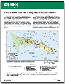
Categories: Publication;
Types: Citation,
Map Service,
OGC WFS Layer,
OGC WMS Layer,
OGC WMS Service;
Tags: Fact Sheet
Brackish groundwater (BGW), defined for this assessment as having a dissolved-solids concentration between 1,000 and 10,000 milligrams per liter is an unconventional source of water that may offer a partial solution to current (2016) and future water challenges. In support of the National Water Census, the U.S. Geological Survey has completed a BGW assessment to gain a better understanding of the occurrence and character of BGW resources of the United States as an alternative source of water. Analyses completed as part of this assessment relied on previously collected data from multiple sources, and no new data were collected. One of the most important contributions of this assessment was the creation of a database...
Categories: Data;
Types: Citation,
Downloadable,
Map Service,
OGC WFS Layer,
OGC WMS Layer,
OGC WMS Service;
Tags: Alaska,
American Samoa,
Guam,
Hawaii,
Puerto Rico,
This data shows select streamgage locations throughout the Red River of the North Basin upstream of Emerson, Manitoba, and basin outlines for eight subbasins..
Categories: Data;
Types: Citation,
Downloadable,
Map Service,
OGC WFS Layer,
OGC WMS Layer,
Shapefile;
Tags: Crookston,
Emerson,
Fargo,
Halstad,
Kindred,
The travel time map was generated using the Pedestrian Evacuation Analyst model from the USGS. The travel time analysis uses ESRI's Path Distance tool to find the shortest distance across a cost surface from any point in the hazard zone to a safe zone. This cost analysis considers the direction of movement and assigns a higher cost to steeper slopes, based on a table contained within the model. The analysis also adds in the energy costs of crossing different types of land cover, assuming that less energy is expended walking along a road than walking across a sandy beach. To produce the time map, the evacuation surface output from the model is grouped into 1-minute increments for easier visualization. The times in...
Categories: Data;
Types: Citation,
Downloadable,
Map Service,
OGC WFS Layer,
OGC WMS Layer,
Shapefile;
Tags: Del Norte County,
evacuation,
hazard preparedness,
hazards,
tsunamis,
Region(s) of distribution of Arctic Lamprey (Lethenteron camtschaticum) (Tilesius, 1811) in the Arctic as digitized for U.S. Geological Survey Scientific Investigations Report 2016-5038. For details on the project and purpose, see the report at https://doi.org/10.3133/sir20165038. Complete metadata for the collection of species datasets is in the metadata document "Dataset_for_Alaska_Marine_Fish_Ecology_Catalog.xml" at https://doi.org/10.5066/F7M61HD7. Source(s) for this digitized data layer are listed in the metadata Process Steps section. Note that the original source may show an extended area; some datasets were limited to the published map boundary. Distributions of marine fishes are shown in adjacent Arctic...
Categories: Data;
Types: Citation,
Downloadable,
Map Service,
OGC WFS Layer,
OGC WMS Layer,
Shapefile;
Tags: (Tilesius, 1811),
Alaska,
Arctic,
Arctic,
Arctic Lamprey,
Region(s) of distribution of Arctic Flounder (Liopsetta glacialis) (Pallas, 1776) in the Arctic as digitized for U.S. Geological Survey Scientific Investigations Report 2016-5038. For details on the project and purpose, see the report at https://doi.org/10.3133/sir20165038. Complete metadata for the collection of species datasets is in the metadata document "Dataset_for_Alaska_Marine_Fish_Ecology_Catalog.xml" at https://doi.org/10.5066/F7M61HD7. Source(s) for this digitized data layer are listed in the metadata Process Steps section. Note that the original source may show an extended area; some datasets were limited to the published map boundary. Distributions of marine fishes are shown in adjacent Arctic seas where...
Categories: Data;
Types: Citation,
Downloadable,
Map Service,
OGC WFS Layer,
OGC WMS Layer,
Shapefile;
Tags: (Pallas, 1776),
Alaska,
Arctic,
Arctic,
Arctic Flounder,
Region(s) of distribution of Chum Salmon (Oncorhynchus keta) (Walbaum, 1792) in the Arctic as digitized for U.S. Geological Survey Scientific Investigations Report 2016-5038. For details on the project and purpose, see the report at https://doi.org/10.3133/sir20165038. Complete metadata for the collection of species datasets is in the metadata document "Dataset_for_Alaska_Marine_Fish_Ecology_Catalog.xml" at https://doi.org/10.5066/F7M61HD7. Source(s) for this digitized data layer are listed in the metadata Process Steps section. Note that the original source may show an extended area; some datasets were limited to the published map boundary. Distributions of marine fishes are shown in adjacent Arctic seas where...
Categories: Data;
Types: Citation,
Downloadable,
Map Service,
OGC WFS Layer,
OGC WMS Layer,
Shapefile;
Tags: (Walbaum, 1792),
Alaska,
Arctic,
Arctic,
Beaufort Sea,
Region(s) of distribution of Pink Salmon (Oncorhynchus gorbuscha) (Walbaum, 1792) in the Arctic as digitized for U.S. Geological Survey Scientific Investigations Report 2016-5038. For details on the project and purpose, see the report at https://doi.org/10.3133/sir20165038. Complete metadata for the collection of species datasets is in the metadata document "Dataset_for_Alaska_Marine_Fish_Ecology_Catalog.xml" at https://doi.org/10.5066/F7M61HD7. Source(s) for this digitized data layer are listed in the metadata Process Steps section. Note that the original source may show an extended area; some datasets were limited to the published map boundary. Distributions of marine fishes are shown in adjacent Arctic seas where...
Categories: Data;
Types: Citation,
Downloadable,
Map Service,
OGC WFS Layer,
OGC WMS Layer,
Shapefile;
Tags: (Walbaum, 1792),
Alaska,
Arctic,
Arctic,
Beaufort Sea,
Region(s) of distribution of Gelatinous Seasnail (Liparis fabricii) Krøyer, 1847 in the Arctic as digitized for U.S. Geological Survey Scientific Investigations Report 2016-5038. For details on the project and purpose, see the report at https://doi.org/10.3133/sir20165038. Complete metadata for the collection of species datasets is in the metadata document "Dataset_for_Alaska_Marine_Fish_Ecology_Catalog.xml" at https://doi.org/10.5066/F7M61HD7. Source(s) for this digitized data layer are listed in the metadata Process Steps section. Note that the original source may show an extended area; some datasets were limited to the published map boundary. Distributions of marine fishes are shown in adjacent Arctic seas where...
Categories: Data;
Types: Citation,
Downloadable,
Map Service,
OGC WFS Layer,
OGC WMS Layer,
Shapefile;
Tags: Alaska,
Arctic,
Arctic,
Beaufort Sea,
Bering Sea,
Region(s) of distribution of Atlantic Poacher (Leptagonus decagonus) (Bloch & Schneider, 1801) in the Arctic as digitized for U.S. Geological Survey Scientific Investigations Report 2016-5038. For details on the project and purpose, see the report at https://doi.org/10.3133/sir20165038. Complete metadata for the collection of species datasets is in the metadata document "Dataset_for_Alaska_Marine_Fish_Ecology_Catalog.xml" at https://doi.org/10.5066/F7M61HD7. Source(s) for this digitized data layer are listed in the metadata Process Steps section. Note that the original source may show an extended area; some datasets were limited to the published map boundary. Distributions of marine fishes are shown in adjacent...
Categories: Data;
Types: Citation,
Downloadable,
Map Service,
OGC WFS Layer,
OGC WMS Layer,
Shapefile;
Tags: (Bloch & Schneider, 1801),
Alaska,
Arctic,
Arctic,
Atlantic Poacher,
Region(s) of distribution of Bigeye Sculpin (Triglops nybelini) Jensen, 1944 in the Arctic as digitized for U.S. Geological Survey Scientific Investigations Report 2016-5038. For details on the project and purpose, see the report at https://doi.org/10.3133/sir20165038. Complete metadata for the collection of species datasets is in the metadata document "Dataset_for_Alaska_Marine_Fish_Ecology_Catalog.xml" at https://doi.org/10.5066/F7M61HD7. Source(s) for this digitized data layer are listed in the metadata Process Steps section. Note that the original source may show an extended area; some datasets were limited to the published map boundary. Distributions of marine fishes are shown in adjacent Arctic seas where...
Categories: Data;
Types: Citation,
Downloadable,
Map Service,
OGC WFS Layer,
OGC WMS Layer,
Shapefile;
Tags: Alaska,
Arctic,
Arctic,
Beaufort Sea,
Bering Sea,
This dataset is the result of measurements of groundwater levels in the Equus Beds aquifer near Wichita, Kansas, in January 2016. Potentiometric surfaces are interpolated for the shallow and deep parts of the aquifer, and rasters of the potentiometric surfaces are included in this data release. Wells were classified as being screened in the shallow or deep parts of the aquifer based on station name (some wells have a layer identifier in the station name) or, if no indication of aquifer layer was given in the station name, based on the depth of the well; wells with depths less than 80 feet below land surface were classified as shallow and wells with depths of 80 feet or deeper were classified as deep. Contours with...
Categories: Data;
Types: Citation,
Downloadable,
Map Service,
OGC WFS Layer,
OGC WMS Layer,
Shapefile;
Tags: Arkansas River,
Bentley,
Burrton,
Equus Beds aquifer,
Halstead,
This dataset contains results from electron microprobe analyses for expanded and unexpanded vermiculite samples. These data are provide for samples of vermiculite ore, expanded vermiculite insulation, horticultural products, aggregate, and packing materials derived from mines near Enoree, South Carolina; Libby, Montana; Louisa, Virginia; Palabora, South Africa; Jiangsu, China; and Llano, Texas. An ASCII text file of results is provided in comma-separated by value (csv) format. The file has the name “vermiculite_probe_microanalyses_data.csv”.
From 2013 to 2015, bathymetric surveys of New York City’s six West of Hudson reservoirs (Ashokan, Cannonsville, Neversink, Pepacton, Rondout, and Schoharie) were performed to provide updated capacity tables and bathymetric maps. Depths were surveyed with a single-beam echo sounder and real-time kinematic global positioning system (RTK-GPS) along planned transects at predetermined intervals for each reservoir. A separate set of echo sounder data was collected along transects at oblique angles to the main transects for accuracy assessment. Field survey data was combined with water-surface elevations in a geographic information system to create three-dimensional surfaces representing reservoir-bed elevations in the...
Categories: Data;
Types: Citation,
Downloadable,
Map Service,
OGC WFS Layer,
OGC WMS Layer,
Shapefile;
Tags: Delaware County,
GPS measurement,
Greene County,
Schoharie County,
Schoharie Reservoir,
|

|
