Folder: ROOT ( Show direct descendants )
179 results (171ms)
LocationFilters
Date Range
Extensions Types Contacts
Categories Tag Types
|
Well logs of Charles Newcomb in Bedminster, Somerset, NJ. Information on well and water characteristics provided.
Categories: Physical Item;
Tags: geologic well log
Well logs of Charles Newcomb in Bedminster, Somerset, NJ. Information on well and water characteristics provided.
Categories: Physical Item;
Tags: geologic well log
Electric Log from Oklahoma Geological Survey Oklahoma Petroleum Information Center Facility. Federal Information Processing Standard: SONAT EXPLORATION - NEWCOMB 17-2 Location: CUSTER County OK
Categories: Physical Item;
Tags: Electric Log
Electric Log from Oklahoma Geological Survey Oklahoma Petroleum Information Center Facility. Federal Information Processing Standard: VA BRILL - NEWCOMB 1 Location: CUSTER County OK
Categories: Physical Item;
Tags: Electric Log
Cuttings for well 15-185-00458, the Newcomb 1 by Petroleum, Inc., located in Stafford County, Kansas. Depths from 3100 to 3652 feet. Skips: . Well is located at T. 21 S, R. 13 W, sec. 5, spot: SW SW SW
Categories: Physical Item;
Tags: Rock Cuttings
Cuttings for well 15-169-19030-0001, the NEWCOMB 1 by BROWN, TOM, located in Saline County, Kansas. Depths from 320 to 3281 feet. Skips: . Well is located at T. 14 S, R. 2 W, sec. 30, spot: NE SE NE
Categories: Physical Item;
Tags: Rock Cuttings
Cuttings for well 15-185-00444, the Newcomb 'B' 1 by Petroleum, Inc., located in Stafford County, Kansas. Depths from 3100 to 3629 feet. Skips: . Well is located at T. 21 S, R. 13 W, sec. 5, spot: SE SE NW
Categories: Physical Item;
Tags: Rock Cuttings
Electric Log from Oklahoma Geological Survey Oklahoma Petroleum Information Center Facility. Federal Information Processing Standard: SONAT EXPLORATION - NEWCOMB 13-3 Location: CUSTER County OK
Categories: Physical Item;
Tags: Electric Log
Cuttings for well 15-169-19030-0001, the NEWCOMB 1 by BROWN, TOM, located in Saline County, Kansas. Depths from 320 to 3281 feet. Skips: . Well is located at T. 14 S, R. 2 W, sec. 30, spot: NE SE NE
Categories: Physical Item;
Tags: Rock Cuttings
Cuttings for well 15-185-00458, the Newcomb 1 by Petroleum, Inc., located in Stafford County, Kansas. Depths from 3100 to 3652 feet. Skips: . Well is located at T. 21 S, R. 13 W, sec. 5, spot: SW SW SW
Categories: Physical Item;
Tags: Rock Cuttings
Electric Log from Oklahoma Geological Survey Oklahoma Petroleum Information Center Facility. Federal Information Processing Standard: QUESTAR EXPLORATION - NEWCOMB 2-13 Location: CUSTER County OK
Categories: Physical Item;
Tags: Electric Log
Electric Log from Oklahoma Geological Survey Oklahoma Petroleum Information Center Facility. Federal Information Processing Standard: SONAT EXPLORATION - NEWCOMB 18-3 Location: CUSTER County OK
Categories: Physical Item;
Tags: Electric Log
Cuttings for well 15-185-00444, the Newcomb 'B' 1 by Petroleum, Inc., located in Stafford County, Kansas. Depths from 3100 to 3629 feet. Skips: . Well is located at T. 21 S, R. 13 W, sec. 5, spot: SE SE NW
Categories: Physical Item;
Tags: Rock Cuttings
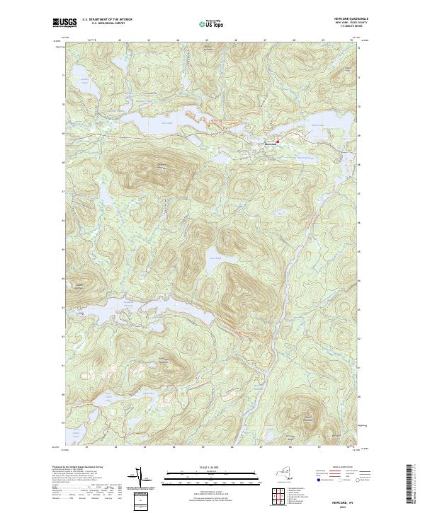
Layered geospatial PDF 7.5 Minute Quadrangle Map. Layers of geospatial data include orthoimagery, roads, grids, geographic names, elevation contours, hydrography, and other selected map features. This map is derived from GIS (geospatial information system) data. It represents a repackaging of GIS data in traditional map form, not creation of new information. The geospatial data in this map are from selected National Map data holdings and other government sources.

Layered geospatial PDF 7.5 Minute Quadrangle Map. Layers of geospatial data include orthoimagery, roads, grids, geographic names, elevation contours, hydrography, and other selected map features. This map is derived from GIS (geospatial information system) data. It represents a repackaging of GIS data in traditional map form, not creation of new information. The geospatial data in this map are from selected National Map data holdings and other government sources.
Cuttings for well 26-063-05017, the PEARL NEWCOMB 'A' 1 by MIAMI PETROLEUM COMPANY, INC, located in unknown County, Nebraska. Depths from 270 to 2110 feet. Skips: . Well is located at T. 5 N, R. 25 W, sec. 28, spot: C NW NW
Categories: Physical Item;
Tags: Rock Cuttings
Cuttings for well 26-063-05017, the PEARL NEWCOMB 'A' 1 by MIAMI PETROLEUM COMPANY, INC, located in unknown County, Nebraska. Depths from 2110 to 3000 feet. Skips: . Well is located at T. 5 N, R. 25 W, sec. 28, spot: C NW NW
Categories: Physical Item;
Tags: Rock Cuttings
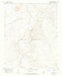
USGS Historical Quadrangle in GeoPDF.

USGS Historical Quadrangle in GeoPDF.
Cuttings for well 15-185-00645, the Newcomb 1 by Westgate-Greenland Oil Co., located in Stafford County, Kansas. Depths from 600 to 3782 feet. Skips: 800-2800. Well is located at T. 21 S, R. 13 W, sec. 5, spot: NE NE SE
Categories: Physical Item;
Tags: Rock Cuttings
|

|
