Folders: ROOT > ScienceBase Catalog > Training Community ( Show all descendants )
46 results (124ms)
Location
Folder
ROOT _ScienceBase Catalog __Training Community Filters
Date Range
Extensions Types
Contacts
Categories Tag Types
|

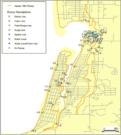
This data set is a point shapefile representing observations of inundation and water levels from the Alaska 1964 event obtained by Tom Horning (1997). The geospatial dataset were derived from a spreadsheet provided by Bruce Jaffe.
Categories: Data;
Types: Citation,
Downloadable,
Map Service,
OGC WFS Layer,
OGC WMS Layer,
Shapefile;
Tags: Oregon,
Seaside, Oregon,
USA,
observations,
tsunami inundation,
Categories: Data;
Types: ArcGIS REST Map Service,
ArcGIS Service Definition,
Downloadable,
Map Service
The Great Plains Landscape Conservation Cooperative (GPLCC, http://www.greatplainslcc.org/) is a partnership that provides applied science and decision support tools to assist natural resource managers conserve plants, fish and wildlife in the mid- and short-grass prairie of the southern Great Plains. It is part of a national network of public-private partnerships — known as Landscape Conservation Cooperatives (LCCs, http://www.fws.gov/science/shc/lcc.html) — that work collaboratively across jurisdictions and political boundaries to leverage resources and share science capacity. The Great Plains LCC identifies science priorities for the region and helps foster science that addresses these priorities to support wildlife...
Landscape conservation cooperatives (LCCs) are conservation-science partnerships between the U.S. Fish and Wildlife Service, U.S. Geological Survey (USGS), and other federal agencies, states, tribes, NGOs, universities and stakeholders within a geographically defined area. They inform resource management decisions to address national-scale stressors-including habitat fragmentation, genetic isolation, spread of invasive species, and water scarcity-all of which are accelerated by climate change.
Categories: Publication;
Types: Citation;
Tags: Artificial Path,
Canal / Ditch,
Colorado,
FWHydrography,
GPLCC,
The data contained in this report was compiled, modified, and analyzed for the Wyoming Landscape Conservation Initiative (WLCI) Integrated Assessment (IA). The WLCI is a long-term science based effort to assess and enhance aquatic and terrestrial habitats at a landscape scale in southwest Wyoming while facilitating responsible energy development through local collaboration and partnerships. The IA is an integrated synthesis and analysis of WLCI resource values based on best available data and information collected from multiple agencies and organizations. It is a support tool for landscape-scale conservation planning and evaluation, and a data and analysis resource that can be used for addressing specific management...
Tags: rare plants
Categories: Data;
Types: ArcGIS REST Map Service,
ArcGIS Service Definition,
Downloadable,
Map Service
Landscape-scale Energy Action Plan (LEAP) Energy, particularly renewable energy, is one of the highest priorities of the DOI. As energy workloads increase, so do conflicts with Federal Trust Resources related to energy projects
Tags: LEAP,
Mountain-Prairie
The U.S. Department of Agriculture, Service Center Agencies should be acknowledged as the data source in products derived from these data. This data set is not designed for use as a primary regulatory tool in permitting or citing decisions, but may be used as a reference source. This information may be interpreted by organizations, agencies, units of government, or others based on needs; however, they are responsible for the appropriate application. Federal, State, or local regulatory bodies are not to reassign to the Service Center Agencies any authority for the decisions that they make. The Service Center Agencies will not perform any evaluations of these data for purposes related solely to State or local regulatory...
Categories: Data;
Types: Downloadable,
GeoTIFF,
Map Service,
Raster;
Tags: Digital Orthophoto,
New Mexico,
Torrance
Categories: Data;
Types: ArcGIS REST Map Service,
ArcGIS Service Definition,
Downloadable,
Map Service
Landscape conservation cooperatives (LCCs) are conservation-science partnerships between the U.S. Fish and Wildlife Service, U.S. Geological Survey (USGS), and other federal agencies, states, tribes, NGOs, universities and stakeholders within a geographically defined area. They inform resource management decisions to address national-scale stressors-including habitat fragmentation, genetic isolation, spread of invasive species, and water scarcity-all of which are accelerated by climate change.
|

|