Folders: ROOT > ScienceBase Catalog > National Geospatial Program > The National Map > USGS 3D Elevation Program (3DEP) Datasets from The National Map > Original Product Resolution (OPR) Source Digital Elevation Models (DEMs) - USGS National Map 3DEP Downloadable Data Collection ( Show all descendants )
5,868,123 results (6s)
Location
Folder
ROOT _ScienceBase Catalog __National Geospatial Program ___The National Map ____USGS 3D Elevation Program (3DEP) Datasets from The National Map _____Original Product Resolution (OPR) Source Digital Elevation Models (DEMs) - USGS National Map 3DEP Downloadable Data Collection Filters
Date Range
Contacts Tag Types Tag Schemes
|

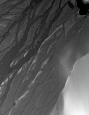
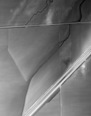
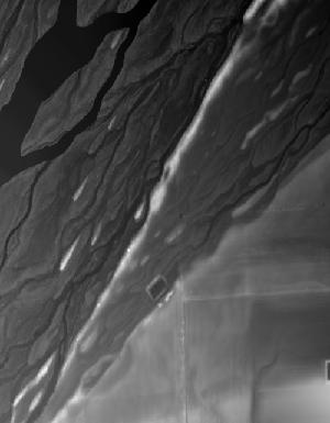
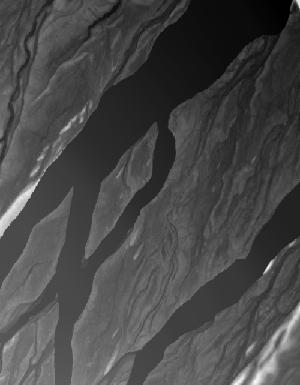
This is the Original Product Resolution (OPR) Digital Elevation Model (DEM) as provided to the USGS. This DEM is delivered in the original resolution, with the original spatial reference. These data may be used as the source of updates to the seamless layers of the 3D Elevation Program, which serves as the elevation layer of the National Map. These data can be used by scientists and resource managers for global change research, hydrologic modeling, resource monitoring, mapping and visualization, and many other applications.

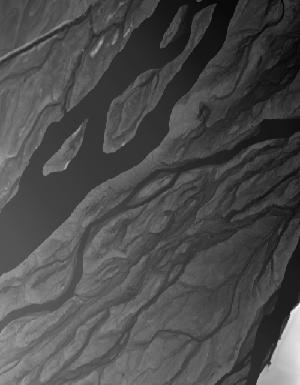
This is the Original Product Resolution (OPR) Digital Elevation Model (DEM) as provided to the USGS. This DEM is delivered in the original resolution, with the original spatial reference. These data may be used as the source of updates to the seamless layers of the 3D Elevation Program, which serves as the elevation layer of the National Map. These data can be used by scientists and resource managers for global change research, hydrologic modeling, resource monitoring, mapping and visualization, and many other applications.
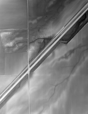
This is the Original Product Resolution (OPR) Digital Elevation Model (DEM) as provided to the USGS. This DEM is delivered in the original resolution, with the original spatial reference. These data may be used as the source of updates to the seamless layers of the 3D Elevation Program, which serves as the elevation layer of the National Map. These data can be used by scientists and resource managers for global change research, hydrologic modeling, resource monitoring, mapping and visualization, and many other applications.

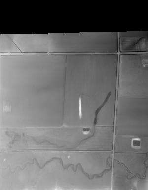
This is the Original Product Resolution (OPR) Digital Elevation Model (DEM) as provided to the USGS. This DEM is delivered in the original resolution, with the original spatial reference. These data may be used as the source of updates to the seamless layers of the 3D Elevation Program, which serves as the elevation layer of the National Map. These data can be used by scientists and resource managers for global change research, hydrologic modeling, resource monitoring, mapping and visualization, and many other applications.

This is the Original Product Resolution (OPR) Digital Elevation Model (DEM) as provided to the USGS. This DEM is delivered in the original resolution, with the original spatial reference. These data may be used as the source of updates to the seamless layers of the 3D Elevation Program, which serves as the elevation layer of the National Map. These data can be used by scientists and resource managers for global change research, hydrologic modeling, resource monitoring, mapping and visualization, and many other applications.

This is the Original Product Resolution (OPR) Digital Elevation Model (DEM) as provided to the USGS. This DEM is delivered in the original resolution, with the original spatial reference. These data may be used as the source of updates to the seamless layers of the 3D Elevation Program, which serves as the elevation layer of the National Map. These data can be used by scientists and resource managers for global change research, hydrologic modeling, resource monitoring, mapping and visualization, and many other applications.

This is the Original Product Resolution (OPR) Digital Elevation Model (DEM) as provided to the USGS. This DEM is delivered in the original resolution, with the original spatial reference. These data may be used as the source of updates to the seamless layers of the 3D Elevation Program, which serves as the elevation layer of the National Map. These data can be used by scientists and resource managers for global change research, hydrologic modeling, resource monitoring, mapping and visualization, and many other applications.

This is the Original Product Resolution (OPR) Digital Elevation Model (DEM) as provided to the USGS. This DEM is delivered in the original resolution, with the original spatial reference. These data may be used as the source of updates to the seamless layers of the 3D Elevation Program, which serves as the elevation layer of the National Map. These data can be used by scientists and resource managers for global change research, hydrologic modeling, resource monitoring, mapping and visualization, and many other applications.

This is the Original Product Resolution (OPR) Digital Elevation Model (DEM) as provided to the USGS. This DEM is delivered in the original resolution, with the original spatial reference. These data may be used as the source of updates to the seamless layers of the 3D Elevation Program, which serves as the elevation layer of the National Map. These data can be used by scientists and resource managers for global change research, hydrologic modeling, resource monitoring, mapping and visualization, and many other applications.

This is the Original Product Resolution (OPR) Digital Elevation Model (DEM) as provided to the USGS. This DEM is delivered in the original resolution, with the original spatial reference. These data may be used as the source of updates to the seamless layers of the 3D Elevation Program, which serves as the elevation layer of the National Map. These data can be used by scientists and resource managers for global change research, hydrologic modeling, resource monitoring, mapping and visualization, and many other applications.

This is the Original Product Resolution (OPR) Digital Elevation Model (DEM) as provided to the USGS. This DEM is delivered in the original resolution, with the original spatial reference. These data may be used as the source of updates to the seamless layers of the 3D Elevation Program, which serves as the elevation layer of the National Map. These data can be used by scientists and resource managers for global change research, hydrologic modeling, resource monitoring, mapping and visualization, and many other applications.
This is the Original Product Resolution (OPR) Digital Elevation Model (DEM) as provided to the USGS. This DEM is delivered in the original resolution, with the original spatial reference. These data may be used as the source of updates to the seamless layers of the 3D Elevation Program, which serves as the elevation layer of the National Map. These data can be used by scientists and resource managers for global change research, hydrologic modeling, resource monitoring, mapping and visualization, and many other applications.
This is the Original Product Resolution (OPR) Digital Elevation Model (DEM) as provided to the USGS. This DEM is delivered in the original resolution, with the original spatial reference. These data may be used as the source of updates to the seamless layers of the 3D Elevation Program, which serves as the elevation layer of the National Map. These data can be used by scientists and resource managers for global change research, hydrologic modeling, resource monitoring, mapping and visualization, and many other applications.

This is the Original Product Resolution (OPR) Digital Elevation Model (DEM) as provided to the USGS. This DEM is delivered in the original resolution, with the original spatial reference. These data may be used as the source of updates to the seamless layers of the 3D Elevation Program, which serves as the elevation layer of the National Map. These data can be used by scientists and resource managers for global change research, hydrologic modeling, resource monitoring, mapping and visualization, and many other applications.

This is the Original Product Resolution (OPR) Digital Elevation Model (DEM) as provided to the USGS. This DEM is delivered in the original resolution, with the original spatial reference. These data may be used as the source of updates to the seamless layers of the 3D Elevation Program, which serves as the elevation layer of the National Map. These data can be used by scientists and resource managers for global change research, hydrologic modeling, resource monitoring, mapping and visualization, and many other applications.
This is the Original Product Resolution (OPR) Digital Elevation Model (DEM) as provided to the USGS. This DEM is delivered in the original resolution, with the original spatial reference. These data may be used as the source of updates to the seamless layers of the 3D Elevation Program, which serves as the elevation layer of the National Map. These data can be used by scientists and resource managers for global change research, hydrologic modeling, resource monitoring, mapping and visualization, and many other applications.

This is the Original Product Resolution (OPR) Digital Elevation Model (DEM) as provided to the USGS. This DEM is delivered in the original resolution, with the original spatial reference. These data may be used as the source of updates to the seamless layers of the 3D Elevation Program, which serves as the elevation layer of the National Map. These data can be used by scientists and resource managers for global change research, hydrologic modeling, resource monitoring, mapping and visualization, and many other applications.
This is the Original Product Resolution (OPR) Digital Elevation Model (DEM) as provided to the USGS. This DEM is delivered in the original resolution, with the original spatial reference. These data may be used as the source of updates to the seamless layers of the 3D Elevation Program, which serves as the elevation layer of the National Map. These data can be used by scientists and resource managers for global change research, hydrologic modeling, resource monitoring, mapping and visualization, and many other applications.
This is the Original Product Resolution (OPR) Digital Elevation Model (DEM) as provided to the USGS. This DEM is delivered in the original resolution, with the original spatial reference. These data may be used as the source of updates to the seamless layers of the 3D Elevation Program, which serves as the elevation layer of the National Map. These data can be used by scientists and resource managers for global change research, hydrologic modeling, resource monitoring, mapping and visualization, and many other applications.
This is the Original Product Resolution (OPR) Digital Elevation Model (DEM) as provided to the USGS. This DEM is delivered in the original resolution, with the original spatial reference. These data may be used as the source of updates to the seamless layers of the 3D Elevation Program, which serves as the elevation layer of the National Map. These data can be used by scientists and resource managers for global change research, hydrologic modeling, resource monitoring, mapping and visualization, and many other applications.
|

|
