Filters: Tags: Ajo (X)
43 results (51ms)|
Filters
Date Range
Contacts
Categories Tag Types
|
ADMMR map collection: New Cornelia, Geophysical Section, Line No. A; 25 x 25 in.
ADMMR map collection: New Cornelia, Property Map; 1 in. to 2000 feet; 19 x 20 in.
These data were compiled for Cabeza Prieta National Wildlife Refuge (CPNWR) in southern Arizona, to support managment efforts of water resources and wildlife conservation. Objective(s) of our study were to 1) measure water storage capacity at select stage heights in three tanks (also termed tinajas), 2) build a stage storage model to help CPNWR staff accurately estimate water volumes throughout the year, and 3) collect topographic data adjacent to the tanks as a means to help connect these survey data to past or future work. These data represent high-resolution (sub-meter) ground based lidar measurements used to meet these objectives and are provided as: processed lidar files (point clouds), rasters (digital elevation...
ADMMR map collection: New Cornelia Mine, Plan of Levels; 1 in. to 500 feet; 17 x 23 in.
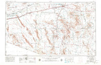
USGS Historical Quadrangle in GeoPDF.

USGS Historical Quadrangle in GeoPDF.
These data were compiled for Cabeza Prieta National Wildlife Refuge (CPNWR) in southern Arizona, to support managment efforts of water resources and wildlife conservation. Objective(s) of our study were to 1) measure water storage capacity at select stage heights in three tanks (also termed tinajas), 2) build a stage storage model to help CPNWR staff accurately estimate water volumes throughout the year, and 3) collect topographic data adjacent to the tanks as a means to help connect these survey data to past or future work. These data represent high-resolution (sub-meter) ground based lidar measurements used to meet these objectives and are provided as: processed lidar files (point clouds), rasters (digital elevation...
The early leaching plant at the New Cornelia mine.
The early electrolytic tank house at the New Cornelia mine.
A man operating a haul truck that is dumping a load of ore at the New Cornelia mine.

USGS Historical Quadrangle in GeoPDF.
ADMMR map collection: New Cornelia, Geophysical Section, Line No. D; 19 x 24 in.
ADMMR map collection: Plan of Levels, New Cornelia Mine; 1 in. to 500 feet; 17 x 25 in.

USGS Historical Quadrangle in GeoPDF.
ADMMR map collection: New Cornelia Mine Geologic Map; 1 in. to 500 feet; 17 x 23 in.
An overview of the smelter at Ajo, Arizona.
ADMMR map collection: New Cornelia, Geophysical Plan, Line 1E; 1 in. to 600 feet; 26 x 11 in.
Two ore trains being loaded by electric shovels in the New Cornelia pit. Each train is hauled by a 2250 h.p. diesel-electric locomotive.
ADMMR map collection: New Cornelia, Geophysical Plan, Line 1E; 1 in. to 600 feet; 26 x 12 in.
These data were compiled for Cabeza Prieta National Wildlife Refuge (CPNWR) in southern Arizona, to support managment efforts of water resources and wildlife conservation. Objective(s) of our study were to 1) measure water storage capacity at select stage heights in three tanks (also termed tinajas), 2) build a stage storage model to help CPNWR staff accurately estimate water volumes throughout the year, and 3) collect topographic data adjacent to the tanks as a means to help connect these survey data to past or future work. These data represent high-resolution (sub-meter) ground based lidar measurements used to meet these objectives and are provided as: processed lidar files (point clouds), rasters (digital elevation...
|

|
