Filters
Date Range
Extensions
Types
Contacts
Categories
Tag Types
Tag Schemes
|
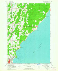
USGS Historical Quadrangle in GeoPDF.
Tags: 7.5 x 7.5 minute,
Birch Creek,
Downloadable Data,
GeoPDF,
GeoTIFF, All tags...
Historical Topographic Maps,
Historical Topographic Maps 7.5 x 7.5 Minute Map Series,
MI,
Map,
imageryBaseMapsEarthCover, Fewer tags

This report provides detailed (1:63,360-scale) mapping of portions of U.S. Geological Survey Circle B-2 (1955), B-3 (1955), B-4 (1952), C-2 (1955), C-3 (1955), and C-4 (1952) quadrangles. The area is part of the Circle mining district and adjacent to the Fairbanks mining district. This report includes detailed geologic, structural, stratigraphic, and geochronologic data. Based on the resulting geologic maps, field investigations, and laboratory materials analyses, the project has also generated derivative maps of geologic construction materials and geologic hazards.
Tags: Aereal,
Aerial Photography,
Aeromagnetic Survey,
Age Dates,
Alaska, State of, All tags...
Alluvial Deposits,
Alluvium,
Amphibolite,
Ar-Ar,
Bedrock,
Bibliography,
Birch Creek,
C14,
Carbonates,
Circle Hot Springs,
Circle Mining District,
Circle Quadrangle,
Clastics,
Coal,
Colluvial Deposits,
Colluvium,
Conductivity Survey,
Conodonts,
Crooked Creek,
Electromagnetic Survey,
Fan,
Faulting,
Faults,
Fluvial,
Folding,
Fossils,
Geologic,
Geomorphology,
Glacial,
Glacial Deposits,
Glacial Drift,
Granite,
Hornblende,
Hornfels,
Igneous Rocks,
K-Ar,
Magnetite,
Major Oxides,
Mammoth Creek,
Mastodon Dome,
Metamorphic Grade,
Metamorphic Minerals,
Metamorphism,
Mineralogy,
Modal Analysis,
Petrography,
Plutonic,
Plutonic Hosted,
Porphyry,
Precious Metals,
Quartz,
Regional,
Regional Metamorphism,
Sample Location,
Sandstone,
Schist,
Sedimentary,
Structure,
Surficial,
Tectonics,
Terranes,
geoscientificInformation, Fewer tags

This report presents the results of a harvest survey and ethnographic research project that investigated the subsistence uses of large land mammals and furbearers in Game Management Unit 25 in the Yukon Flats region of Interior Alaska. Large land mammal species harvested and used by Yukon Flats residents include moose Alces alces, caribou Rangifer tarandus, black bear Ursus americanus, and brown bear Ursus arctos. Furbearing species included in this study are marten Martes americana, lynx Lynx canadensis, and wolf Canis lupus. For the 2008–2009 study year a total of 284 of 467 households (approximately 61%) were surveyed in the 7 Yukon Flats communities of Beaver, Birch Creek, Chalkyitsik, Circle, Fort Yukon, Stevens...
Categories: Data,
Publication;
Types: Citation,
Downloadable,
Map Service,
OGC WFS Layer,
OGC WMS Layer,
Shapefile;
Tags: B5-Beavers,
Beaver,
Birch Creek,
Black River,
Chalkyitsik, All tags...
Circle,
Fort Yukon,
Gwich’in,
Interior Alaska,
Koyukon,
Porcupine River,
R2a-Impact Climate Change Vegatation and Subsistence,
Stevens Village,
Venetie,
Yukon Flats,
Yukon River,
black bear,
brown bear,
caribou,
furbearer trapping,
moose,
subsistence harvests, Fewer tags
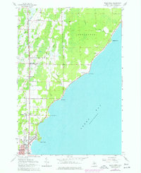
USGS Historical Quadrangle in GeoPDF.
Tags: 7.5 x 7.5 minute,
Birch Creek,
Downloadable Data,
GeoPDF,
GeoTIFF, All tags...
Historical Topographic Maps,
Historical Topographic Maps 7.5 x 7.5 Minute Map Series,
MI,
Map,
imageryBaseMapsEarthCover, Fewer tags

The 1:100,000-scale geologic map database of the South Boston 30' × 60' quadrangle, Virginia and North Carolina, provides geologic information for the Piedmont along the I-85 and U.S. Route 58 corridors and in the Roanoke River watershed, which includes the John H. Kerr Reservoir and Lake Gaston. The Raleigh terrane (located on the eastern side of the map) contains Neoproterozoic to early Paleozoic(?) polydeformed, amphibolite-facies gneisses and schists. The Carolina slate belt of the Carolina terrane (located in the central part of the map) contains Neoproterozoic metavolcanic and metasedimentary rocks at greenschist facies. Although locally complicated, the slate-belt structure mapped across the South Boston...
Tags: 30 x 60 minute,
Aaron Formation,
Aarons Creek,
Alkaline basalt,
Allen Creek, All tags...
Alluvium,
Amphibolite,
Argillite,
Armistead Branch,
Ashcake Creek,
Augen gneiss,
Averett,
Bagleys Mills,
Banister Lake,
Banister River,
Barnes Junction,
Basalt,
Baskerville,
Bears Element Creek,
Beaver Pond,
Beaver Pond Creek,
Beech Creek,
Bethel Hill,
Big Hounds Creek,
Big Juniper Creek,
Biotite gneiss,
Birch Creek,
Bishops Corner,
Black Walnut Creek,
Blackridge,
Blackstone Creek,
Blanes Millpond,
Bluestone Creek,
Bluestone Otter Creek,
Bluewing Creek,
Bowes Branch,
Boydton,
Bracey,
Brodnax,
Brunswick County,
Buckham Creek,
Buckhorn Creek,
Buckskin Creek,
Buffalo Creek,
Buffalo Junction,
Buffalo Springs,
Buggs Island,
Burton Branch,
Butcher Creek,
Cambrian,
Cargills Creek,
Carolina slate belt,
Carolina terrane,
Castle Creek,
Castle Heights,
Cataclasite,
Catawba Creek,
Cedar Creek,
Cenozoic,
Charlotte County,
Chase City,
Christie,
Clarksville,
Clarkton,
Clays Mill,
Clover,
Clover Creek,
Cluster Springs,
Coleman Creek,
Colluvium,
Conglomerate,
Connor Lake,
Cotton Creek,
Couches Creek,
Country Line complex,
Cox Creek,
Crooked Creek,
Crupper Run,
Crystal Hill,
Cub Creek,
Cunningham complex,
Dacite,
Dan River,
Devils Branch,
Devonian,
Diabase,
Difficult Creek,
Diorite,
Dixon Millpond,
Dockery Creek,
Drakes Branch,
Dryburg,
Dudley,
Dundas,
Ellis Creek,
Esnon,
Evans Creek,
Farmers Branch,
Felsic gneiss,
Finchley,
Finnewood Creek,
Finneywood,
Flat Creek,
Flat Rock Creek,
Forksville,
Formosa,
Fort Mitchell,
Gabbro,
Gibson Creek,
Gilliams Branch,
Gneiss,
Goodell Creek,
Granite,
Granitic gneiss,
Granodiorite,
Granville County,
Grassy Creek,
Great Creek,
Greenschist,
Gregory Corner,
Hagood Creek,
Halifax,
Halifax County,
Harmony,
Hawtree Creek,
Hitesburg,
Holocene,
Horsepen Creek,
Horseshoe Lake,
Hughs Lake,
Hunting Creek,
Hyco Formation,
Hyco River,
Island Creek,
Island Creek Reservoir,
Jeffress,
Johnson Creek,
Jurassic,
Kenbridge,
Kerr Reservoir,
Kettle Creek,
Kettlesticks Creek,
Kits Creek,
La Crosse,
Lake Gaston,
Lake Gordon,
Langford Pond,
Lawsons Creek,
Layton Creek,
Lennig,
Little Genito Creek,
Little Horsepen Creek,
Little Johnson Creek,
Little Juniper Creek,
Little Temble Creek,
Long Branch,
Lunenburg,
Lunenburg County,
Lyle Creek,
Marengo,
Mason Creek,
Mayo,
Mayo Creek,
Mayo Reservoir,
Mecklenburg County,
Mesozoic,
Metabasalt,
Metamorphic rock,
Metamorphic suite of South Hill,
Metasedimentary rock,
Metavolcanic rock,
Middle Meherrin River,
Mikes Creek,
Miles Creek,
Mill Branch,
Milton terrane,
Mines Creek,
Miocene,
Miry Creek,
Mississippian,
Mitchell Creek,
Monzodiorite,
Monzonite,
Moody Creek,
Mossingford,
Mount Laurel,
Mountain Creek,
Mylonite,
Nathalie,
Nelson,
Neogene,
Neoproterozoic,
North Carolina,
North Meherrin River,
North View,
Nutbush Creek,
Nutbush Creek mylonite zone,
Omega,
Ontario,
Ordovician,
Orthogneiss,
Otter Creek,
Paleozoic,
Palmer Crossroads,
Palmer Springs,
Panhandle Creek,
Parham Creek,
Pennsylvanian,
Permian,
Person County,
Peter Creek,
Philbeck Crossroads,
Phyllonite,
Piney Creek,
Piney Grove,
Plantersville,
Pleistocene,
Pliocene,
Poplar Creek,
Public Fork,
Quartz diorite,
Quartz monzonite,
Quartzite,
Quaternary,
Rabat,
Raleigh terrane,
Randolph,
Ready Creek,
Red Bank,
Red Oak,
Redlawn,
Reedy Creek,
Reeses Creek,
Rehoboth,
Reynolds Creek,
Rhyolite,
Riverdale,
Roanoke Creek,
Roanoke River,
Rocky Branch,
Sand,
Sandy Creek,
Saxe,
Schist,
Scotts Crossroad,
Scottsburg,
Seay Creek,
Shiny Rock,
Siddon,
Siltstone,
Silurian,
Sinai,
Skipwith,
Smith Creek,
South Boston,
South Hill,
South Meherrin River,
Spanish Grove,
Stokes Creek,
Stony Creek,
Taylors Creek,
Temble Creek,
Terrace,
The Ridge,
Tonalite,
Triassic,
Tungsten,
Twittys Creek,
USGS Science Data Catalog (SDC),
Union Level,
Vance County,
Vance pluton,
Victoria,
Virgilina,
Virgilina Formation,
Virginia,
Wallace Branch,
Warren County,
Wightman,
Winn Creek,
Wolf Trap Creek,
Wylliesburg,
abandoned mines and quarries,
bedrock geologic units,
copper,
earth sciences,
folding (geologic),
foliation (geologic),
fracture (geologic),
geologic contacts,
geologic maps,
geologic processes,
geologic structure,
geologic time periods,
geologic time scales,
geology,
geoscientificInformation,
geospatial datasets,
information product types,
inlandWaters,
lithology,
maps and atlases,
metamorphic rocks,
metamorphism (geological),
mining and quarrying,
place,
sedimentary rocks,
sedimentation,
society,
stratum,
structural geology,
structure,
surficial geologic units,
unconsolidated deposits,
utilitiesCommunication, Fewer tags

The U.S. Geological Survey, in cooperation with Ashokan Watershed Stream Management Program, investigated the feasibility of bedload monitoring in the upper Esopus Creek watershed, Ulster and Greene Counties, New York (NY), from 2017 to 2020. Traditional bedload samples were collected at two locations: Birch Creek at Big Indian, NY, and Stony Clove at Jansen Rd at Lanesville, NY. Active and passive tracers were used at Stony Clove at Jansen Rd at Lanesville, NY, to measure bed material displacement associated with storm runoff.
Categories: Data;
Tags: Birch Creek,
Catskill Mountains,
Esopus Creek,
Hydrology,
Sediment, All tags...
Sedimentology,
Stony Clove Creek,
Surface-Water Quality Monitoring,
USGS Science Data Catalog (SDC),
Water Quality,
Water Quality,
Water Resources,
hydrology,
sediment transport, Fewer tags
|
|

