Filters
Date Range
Contacts
Categories
Tag Types
Tag Schemes
|

This location is part of the Arizona Mineral Industry Location System (AzMILS), an inventory of mineral occurences, prospects and mine locations in Arizona. Pinal75 is located in T1S R11E Sec 26 NW in the Picketpost Mtn - 7.5 Min quad. This collection consists of various reports, maps, records and related materials acquired by the Arizona Department of Mines and Mineral Resources regarding mining properties in Arizona. Information was obtained by various means, including the property owners, exploration companies, consultants, verbal interviews, field visits, newspapers and publications. Some sections may be redacted for copyright. Please see the access statement.
Categories: Data;
Tags: 1920s,
1940s,
1950s,
1980s,
Arizona, All tags...
Bombay,
Bum Boy,
Copper, Oxide,
Copper, Sulfide,
Dataset,
King Copper Group,
Lead,
Picketpost Mtn - 7.5 Min,
Pinal,
Silver,
Superior physiographic area,
T1S R11E Sec 26 NW,
United States,
Vanadium,
Wood Camp Canyon metallic mineral dist.,
chemical analysis,
economic geology,
geologic maps,
geoscientificInformation,
gold ores,
image collections,
maps and atlases,
metallic ores,
mineral resources,
mineralogy,
mining and quarrying,
reports,
subsurface maps,
topographic maps, Fewer tags

Mountainous landscape near the Bomboy mine.
Categories: Data;
Tags: 1940s,
Arizona,
Bombay,
Bum Boy,
Copper, Oxide, All tags...
Dataset,
King Copper Group,
Picketpost Mtn - 7.5 Min,
Pinal,
Superior physiographic area,
T1S R11E Sec 26 NW,
United States,
Wood Camp Canyon metallic mineral dist.,
geoscientificInformation,
image collections,
landscape photographs,
mining,
photographic prints, Fewer tags
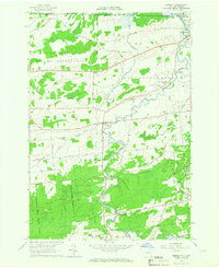
USGS Historical Quadrangle in GeoPDF.
Tags: 7.5 x 7.5 minute,
Bombay,
Downloadable Data,
GeoPDF,
GeoTIFF, All tags...
Historical Topographic Maps,
Historical Topographic Maps 7.5 x 7.5 Minute Map Series,
Map,
NY,
imageryBaseMapsEarthCover, Fewer tags

USGS Historical Quadrangle in GeoPDF.
Tags: 7.5 x 7.5 minute,
Bombay,
Downloadable Data,
GeoPDF,
GeoTIFF, All tags...
Historical Topographic Maps,
Historical Topographic Maps 7.5 x 7.5 Minute Map Series,
Map,
NY,
imageryBaseMapsEarthCover, Fewer tags

Equipment and a person at the Bomboy mine with rails in the foreground.
Categories: Data;
Tags: 1940s,
Arizona,
Bombay,
Bum Boy,
Copper, Oxide, All tags...
Dataset,
King Copper Group,
Picketpost Mtn - 7.5 Min,
Pinal,
Superior physiographic area,
T1S R11E Sec 26 NW,
United States,
Wood Camp Canyon metallic mineral dist.,
adults,
geoscientificInformation,
image collections,
mining,
photographic prints,
railroads, Fewer tags

The boundaries illustrated by these Assessment Units are the result of geologic studies conducted by the World Petroleum Resources Project, 2009-2011 (Project). The boundaries were used to assess the oil and gas resources within the unit. An assessment unit, as defined by the Project, is a mapped volume of rock within the Total Petroleum System (TPS), sufficiently homogeneous in terms of geology, exploration strategy and risk characteristics to constitute a single population of discovered and undiscovered fields with respect to criteria used for resource assessment. Relatedly, the TPS is the essential elements and processes, as well as all genetically related hydrocarbons that occur in petroleum shows, seeps and...
Categories: Data,
pre-SM502.8;
Tags: Afghan-Tajik Basin,
Alberta Basin,
Amazonas Basin,
Amu-Darya Basin,
Anah Graben, All tags...
Anglo-Dutch Basin,
Arafura Basin-Irian Jaya,
Assam,
Assessment,
Assessment Unit,
Azov-Kuban Basin,
Bahama Platform,
Banda Arc,
Baram Delta/Brunei-Sabah Basin,
Barinas-Apure Basin,
Barito Basin,
Baykit High,
Bintuni-Sulawati,
Bohaiwan Basin,
Bombay,
Bonaparte Basin,
Browse Basin,
Burgos Basin,
Campeche-Sigsbee Salt Basin,
Campos Basin,
Cauvery,
Central Sumatra Basin,
Chad,
Conventional Resources,
Cuu Long Basin,
Dnieper-Donets Basin,
East Java Basin,
East Venezuela Basin,
Energy Program,
Espirito Santo Basin,
Essaouira Basin,
Euphrates/Mardin,
Fahud Salt Basin,
Falklands Plateau,
Farah,
Foz do Amazonas Basin,
Geologic Oil and Gas Assessment,
Geological Provinces,
Geology,
Ghaba Salt Basin,
Gippsland Basin,
Grand Erg/Ahnet Basin,
Greater Antilles Deformed Belt,
Greater Ghawar Uplift,
Greater Sarawak Basin,
Guajira Basin,
Gulf of Guinea,
Guyana-Suriname Basin,
Haleb,
Helmund-Baluchistan,
Illizi Basin,
Indo-Burman,
Interior Homocline-Central Arch,
Irrawaddy,
Junggar Basin,
Katawaz,
Khorat Plateau,
Krishna-Godavari,
Kura Basin,
Kutei Basin,
Labrador-Newfoundland Shelf,
Lesser Antilles Deformed Belt,
Levant Basin,
Llanos Basin,
Lower Magdalena Valley Basin,
Ma'Rib-Al Jawf/Masila Basin,
Macuspana Basin,
Magallanes Basin,
Malay Basin,
Malvinas Basin,
Maracaibo Basin,
Mesopotamian Foredeep Basin,
Middle Caspian Basin,
Middle Magdalena Valley Basin,
Morondava,
Mozambique Coastal,
Nam Con Son Basin,
Nepa-Botuoba High,
Neuquen Basin,
New Guinea Foreland Basin-Fold Belt,
Niger Delta,
Nile Delta Basin,
North Caspian Basin,
North Sakhalin Basin,
North Sea Graben,
North Sumatra Basin,
North Ustyurt Basin,
Northwest Java Basin,
Northwest Shelf,
Norwegian Margin,
Oil and Gas,
Oil and Gas Assessment,
Orange River Basin,
Ordos Basin,
Palawan Shelf,
Palmyra Zone,
Papuan Basin-Shelf Platform,
Parana Basin,
Parnaiba Basin,
Pearl River Mouth Basin,
Pelagian Basin,
Pelotas Basin,
Penyu-West Natuna Basin,
Petroleum,
Phu Khanh,
Po Basin,
Pripyat Basin,
Provence Basin,
Putumayo-Oriente-Maranon Basin,
Qatar Arch,
Red Sea Basin,
Rub al Khali Basin,
Rutbah Uplift,
Salado-Punta del Este Basin,
Saline-Comalcalco Basin,
San Jorge Basin,
Santa Cruz-Tarija Basin,
Santos Basin,
Senegal,
Sergipe-Alagoas Basin,
Seychelles,
Sichuan Basin,
Sierra Madre de Chiapas-Peten Foldbelt,
Sirte Basin,
Solimoes Basin,
Song Hong Basin,
Songliao Basin,
South African Coastal,
South Caspian Basin,
South China Sea Platform,
South Oman Salt Basin,
South Sumatra Basin,
Sud,
Sulu Sea,
Tampico-Misantla Basin,
Tanzania Coastal,
Tarakan Basin,
Taranaki Basin,
Tarim Basin,
Thai Basin,
Thailand Cenozoic Basins,
Tobago Trough,
Trias/Ghadames Basin,
Tuxla Uplift,
U.S. Geological Survey,
USGS,
USGS Science Data Catalog (SDC),
Upper Magdalena Valley Basin,
Veracruz Basin,
Villahermosa Uplift,
Volga-Ural Region,
West African Coastal,
West Siberian Basin,
West-Central Coastal,
Widyan Basin-Interior Platform,
World,
World Petroleum Resource Assessment,
Yucatan Platform,
Zagros Fold Belt,
Zagros Thrust Zone,
wep, Fewer tags

Panorama of the mountainous terrain near the Bomboy mine.
Categories: Data;
Tags: 1940s,
Arizona,
Bombay,
Bum Boy,
Copper, Oxide, All tags...
Dataset,
King Copper Group,
Picketpost Mtn - 7.5 Min,
Pinal,
Superior physiographic area,
T1S R11E Sec 26 NW,
United States,
Wood Camp Canyon metallic mineral dist.,
geoscientificInformation,
image collections,
landscape photographs,
mining,
photographic prints, Fewer tags
|
|

