Filters: Tags: Cumberland Island (X)
14 results (28ms)|
Filters
Date Range
Extensions Types Contacts
Categories Tag Types Tag Schemes |

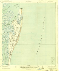
USGS Historical Quadrangle in GeoPDF.
Sandy ocean beaches in the United States are popular tourist and recreational destinations and constitute some of the most valuable real estate in the country. The boundary between land and water along the coastline is often the location of concentrated residential and commercial development and is frequently exposed to a range of natural hazards, which include flooding, storm effects, and coastal erosion. In response, the U.S. Geological Survey (USGS) is conducting a national assessment of coastal change hazards. One component of this research effort, the National Assessment of Shoreline Change Project (http://coastal.er.usgs.gov/shoreline-change/), documents changes in shoreline position as a proxy for coastal...
Categories: Data;
Types: Citation,
Downloadable,
Map Service,
OGC WFS Layer,
OGC WMS Layer,
Shapefile;
Tags: Atlantic Coast,
CMGP,
Coastal and Marine Geology Program,
Cumberland Island,
DSAS,
Sandy ocean beaches in the United States are popular tourist and recreational destinations and constitute some of the most valuable real estate in the country. The boundary between land and water along the coastline is often the location of concentrated residential and commercial development and is frequently exposed to a range of natural hazards, which include flooding, storm effects, and coastal erosion. In response, the U.S. Geological Survey (USGS) is conducting a national assessment of coastal change hazards. One component of this research effort, the National Assessment of Shoreline Change Project (http://coastal.er.usgs.gov/shoreline-change/), documents changes in shoreline position as a proxy for coastal...
Categories: Data;
Types: Citation,
Downloadable,
Map Service,
OGC WFS Layer,
OGC WMS Layer,
Shapefile;
Tags: Accretion,
Atlantic Coast,
CMGP,
Coastal and Marine Geology Program,
Cumberland Island,
This dataset contains daily estimates of erosion for select time windows at four sites along the back barrier margin of Cumberland Island National Seashore (CUIS). The four locations selected for instrumentation are referenced by the name of the general area where they were located and are as follows: Brickhill Bluff (bb), Dungeness Wharf (dw), Plum Orchard (po), and Racoon Key (rk). Additionally, this dataset provides offsets that were used to correct the photo-electric erosion pin (PEEP) erosion values to those measured in the field. Using the offsets and magnitude of erosion between site visits, a running cumulative sum of erosion is also provided.
Categories: Data;
Types: Citation;
Tags: Camden County,
Cumberland Island National Seashore,
Georgia,
barrier islands,
coastal erosion,
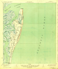
USGS Historical Quadrangle in GeoPDF.
Sandy ocean beaches in the United States are popular tourist and recreational destinations and constitute some of the most valuable real estate in the country. The boundary between land and water along the coastline is often the location of concentrated residential and commercial development and is frequently exposed to a range of natural hazards, which include flooding, storm effects, and coastal erosion. In response, the U.S. Geological Survey (USGS) is conducting a national assessment of coastal change hazards. One component of this research effort, the National Assessment of Shoreline Change Project (http://coastal.er.usgs.gov/shoreline-change/), documents changes in shoreline position as a proxy for coastal...
Categories: Data;
Types: Citation,
Downloadable,
Map Service,
OGC WFS Layer,
OGC WMS Layer,
Shapefile;
Tags: Accretion,
Atlantic Coast,
CMGP,
Coastal and Marine Geology Program,
Cumberland Island,
USGS Historical Quadrangle in GeoPDF.
This dataset contains average sound intensity (in decibels full scale) for time windows when the water level was at or above the margin toe at four sites - Brickhill Bluff (bb), Dungeness Wharf (dw), Plum Orchard (po), and Racoon Key (rk) - along the back barrier margin of CUIS. Data were recorded with submerged hydrophones connected to a continuously recording data-logger. Additionally, this dataset presents average water level conditions when sound measurements were recorded.
Categories: Data;
Types: Citation;
Tags: Camden County,
Cumberland Island National Seashore,
Georgia,
acoustic,
barrier islands,

USGS Historical Quadrangle in GeoPDF.
Sandy ocean beaches in the United States are popular tourist and recreational destinations and constitute some of the most valuable real estate in the country. The boundary between land and water along the coastline is often the location of concentrated residential and commercial development and is frequently exposed to a range of natural hazards, which include flooding, storm effects, and coastal erosion. In response, the U.S. Geological Survey (USGS) is conducting a national assessment of coastal change hazards. One component of this research effort, the National Assessment of Shoreline Change Project (http://coastal.er.usgs.gov/shoreline-change/), documents changes in shoreline position as a proxy for coastal...
Categories: Data;
Types: Citation,
Downloadable,
Map Service,
OGC WFS Layer,
OGC WMS Layer,
Shapefile;
Tags: Accretion,
Atlantic Coast,
CMGP,
Coastal and Marine Geology Program,
Cumberland Island,
Sandy ocean beaches in the United States are popular tourist and recreational destinations and constitute some of the most valuable real estate in the country. The boundary between land and water along the coastline is often the location of concentrated residential and commercial development and is frequently exposed to a range of natural hazards, which include flooding, storm effects, and coastal erosion. In response, the U.S. Geological Survey (USGS) is conducting a national assessment of coastal change hazards. One component of this research effort, the National Assessment of Shoreline Change Project (http://coastal.er.usgs.gov/shoreline-change/), documents changes in shoreline position as a proxy for coastal...
Types: Citation;
Tags: Atlantic Coast,
CMGP,
CSC,
Coastal Services Center,
Coastal and Marine Geology Program,

USGS Historical Quadrangle in GeoPDF.
Sandy ocean beaches in the United States are popular tourist and recreational destinations and constitute some of the most valuable real estate in the country. The boundary between land and water along the coastline is often the location of concentrated residential and commercial development and is frequently exposed to a range of natural hazards, which include flooding, storm effects, and coastal erosion. In response, the U.S. Geological Survey (USGS) is conducting a national assessment of coastal change hazards. One component of this research effort, the National Assessment of Shoreline Change Project (http://coastal.er.usgs.gov/shoreline-change/), documents changes in shoreline position as a proxy for coastal...
Categories: Data;
Types: Citation,
Downloadable,
Map Service,
OGC WFS Layer,
OGC WMS Layer,
Shapefile;
Tags: Atlantic Coast,
Baseline,
CMGP,
Coastal and Marine Geology Program,
Cumberland Island,
This dataset contains cumulative erosion magnitude measured at individual erosion pins at select sites along the western margin of CUIS. Additionally, the data are presented as rates and summarized to the site level to facilitate comparison with other methods used to estimate erosion with slightly varying temporal ranges.
Categories: Data;
Types: Citation;
Tags: Camden County,
Cumberland Island National Seashore,
Georgia,
bank pins,
barrier islands,
|

|
