Filters
Date Range
Extensions
Types
Contacts
Categories
Tag Types
Tag Schemes
|

This composite shaded relief image dataset depicts generalized bathymetry and topography of the Caribbean region.
Categories: Data,
pre-SM502.8;
Tags: AG,
AI,
AN,
AW,
Anguilla, All tags...
Antigua and Barbuda,
Aruba,
Aves Ridge (6109),
BB,
BS,
BZ,
Bahama Platform (6119),
Bahamas,
Barbados,
Barbados Accretionary Complex (6127),
Barinas-Apure Basin (6097),
Bathymetry,
Beata Ridge (6111),
Belize,
Bonaire Basin (6101),
British Virgin Islands,
CO,
CR,
CU,
Cariaco Basin (6102),
Caribbean,
Caribbean region,
Cayman Islands,
Cayman Ridge (6121),
Cayman Trough (6120),
Cesar Basin (6094),
Chiapas Massif-Nuclear Central America (6122),
Choco Pacific Basin (6087),
Colombia,
Colombian Basin (6112),
Costa Rica,
Cuba,
DM,
DO,
Dominica,
Dominican Republic,
Earth Science,
East Venezuela Basin (6098),
El Salvador,
Falcon Basin (6100),
Florida Peninsula (5050),
GD,
GP,
GT,
GY,
Geology,
Greater Antilles Deformed Belt (6117),
Grenada,
Grenada Back-Arc Basin (6126),
Guadeloupe,
Guajira Basin (6095),
Guatemala,
Gulf Cenozoic OCS (5097),
Gulf Cenozoic OCS (5098),
Guyana,
Guyana Shield (6002),
Guyana-Suriname Basin (6021),
HN,
HT,
Haiti,
Honduras,
Image,
JM,
Jamaica,
KN,
KY,
LC,
Lesser Antilles Deformed Belt (6107),
Llanos Basin (6096),
Lower Magdelena (6091),
MQ,
MS,
MX,
Macuspana Basin (5306),
Maracaibo Basin (6099),
Martinique,
Maya Mountains (6125),
Mexico,
Middle America Province (6113),
Middle Magdelena (6090),
Monserrat,
NI,
Neogene Volcanic Belt (6108),
Netherlands Antilles,
Nicaragua,
North Caribbean Deformed Belt (6116),
North Nicaraguan Rise (6114),
Ocean (0),
Ocean (1),
PA,
PR,
Pacific Offshore Basin (6088),
Panama,
Perjira-Venezuela-Coastal Ranges (6093),
Puerto Rico,
Puerto Rico Trench (6118),
SV,
Saline-Comalcalco Basin (5304),
Shaded Relief,
Sierra Madre de Chiapas-Peten Foldbelt (5310),
Sierra Nevada de Santa Marta (6105),
South Caribbean Accretionary Prism (6104),
South Nicaraguan Rise (6115),
St. Kitts and Nevis,
St. Lucia,
St. Vincent and the Grenadines,
Surface,
TC,
TT,
Tobago Trough (6103),
Topography,
Trinidad and Tobago,
Turks and Caicos Islands,
U.S. Geological Survey,
US,
USGS,
USGS Science Data Catalog (SDC),
United States,
VC,
VE,
VI,
VQ,
Venezuela,
Venezuelan Basin (6110),
Villahermosa Uplift (5305),
Virgin Islands,
West-Central Cordillera (6106),
Yucatan Basin (6123),
Yucatan Platform (5308),
caribbean,
elevation,
environment,
geoscientificInformation,
imageryBaseMapsEarthCover,
oilgas,
wep,
worldgeologicmaps, Fewer tags
The Caribbean region is part of World Energy Assessment region 6 (Central and South America). A fundamental task in the assessment is to map the locations and type of production for existing oil and gas fields. The Petroconsultants database is the only available database that has coverage for the Caribbean region. Oil and gas field symbols represent field center-points and are published with permission from Petroconsultants International Data Corporation, 2002 database.
Categories: Data,
pre-SM502.8;
Types: Downloadable,
Map Service,
OGC WFS Layer,
OGC WMS Layer,
Shapefile;
Tags: AG,
AI,
AN,
AW,
Anguilla, All tags...
Antigua and Barbuda,
Aruba,
Assessment,
BB,
BS,
BZ,
Bahamas,
Barbados,
Belize,
British Virgin Islands,
CO,
CR,
CU,
Caribbean,
Cayman Islands,
Colombia,
Costa Rica,
Cuba,
DM,
DO,
Dominica,
Dominican Republic,
Earth Science,
Economic geology,
El Salvador,
GD,
GP,
GT,
GY,
Gas,
Geology,
Geology,
Greneda,
Guadeloupe,
Guatemala,
Guyana,
HN,
HT,
Haiti,
Honduras,
JM,
Jamaica,
KN,
KY,
LC,
MQ,
MS,
MX,
Martinique,
Mexico,
Monserrat,
NI,
Natural Gas,
Natural Resourses,
Natural gas resources,
Netherlands Antilles,
Nicaragua,
Oil,
Oil and Gas Fields,
Oil resources,
PA,
PR,
Panama,
Petroleum,
Petroleum,
Puerto Rico,
Resource Assessment,
SV,
St. Kitts and Nevis,
St. Lucia,
St. Vincent and the Grenadines,
TC,
TT,
Trinidad and Tobago,
Turks and Caicas Islands,
U.S. Geological Survey,
US,
USGS,
USGS Science Data Catalog (SDC),
United States,
VC,
VE,
VI,
VQ,
Venezuela,
Virgin Islands,
World Energy Project,
World Energy Resources,
caribbean,
economy,
environment,
geoscientificInformation,
imageryBaseMapsEarthCover,
oilgas,
wep,
worldgeologicmaps, Fewer tags
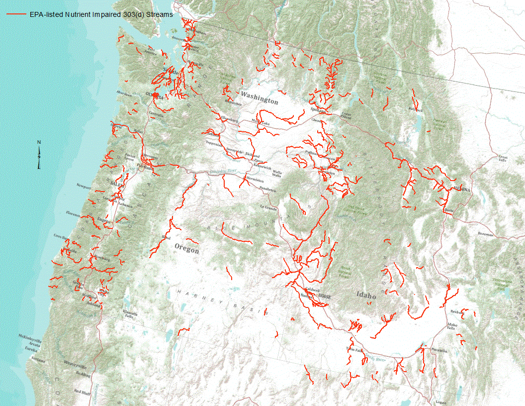
“Under section 303(d) of the 1972 Clean Water Act, states, territories, and authorized tribes are required to develop lists of impaired waters. These impaired waters do not meet water quality standards that states, territories, and authorized tribes have set for them, even after point sources of pollution have installed the minimum required levels of pollution control technology. The law requires that these jurisdictions establish priority rankings for waters on the lists and develop TMDLs for these waters” (U.S. Environmental Protection Agency, 2011). Waterways represented in this data set are a subset of these EPA 303 (d) listed streams that were classified as nutrient impaired. Nutrient impaired streams include...
Tags: 303d,
Columbia River Basin,
DO,
Hydrological,
Hydrology, All tags...
Idaho,
Montana,
NPLCC,
Nevada,
Nitrogen,
North Pacific Landscape Conservation Cooperative,
Nutrients,
Oregon,
Phosphorus,
Puget Sound,
USGS,
Washington,
Wyoming,
contaminants,
impaired,
inlandWaters,
pH,
water resources, Fewer tags

These data were released prior to the October 1, 2016 effective date for the USGS’s policy dictating the review, approval, and release of scientific data as referenced in USGS Survey Manual Chapter 502.8 Fundamental Science Practices: Review and Approval of Scientific Data for Release. Under section 303(d) of the 1972 Clean Water Act, states, territories, and authorized tribes are required to develop lists of impaired waters. These impaired waters do not meet water quality standards that states, territories, and authorized tribes have set for them, even after point sources of pollution have installed the minimum required levels of pollution control technology. The law requires that these jurisdictions establish...
Tags: 303d,
Columbia River Basin,
DO,
Idaho,
Montana, All tags...
NSDI,
Nevada,
Nitrogen,
Nutrients,
Oregon,
Phosphorus,
Puget Sound,
USGS Science Data Catalog (SDC),
Washington,
Wyoming,
contaminants,
environment,
geoscientificInformation,
impaired,
inlandWaters,
inlandWaters,
pH, Fewer tags

This dataset includes a modified subset of polygon features that describe U.S. Geological Survey's defined geologic provinces of the World. Each province has a set of geologic characteristics that distinguish it from surrounding provinces. These characteristics may include dominant lithologies, the age of the strata, and/or structural type. Each province is assigned a unique numeric code and may fall within two or more countries or assessment regions.
Categories: Data,
pre-SM502.8;
Types: Downloadable,
Map Service,
OGC WFS Layer,
OGC WMS Layer,
Shapefile;
Tags: AG,
AI,
AN,
AW,
Anguilla, All tags...
Antigua and Barbuda,
Aruba,
Aves Ridge (6109),
BB,
BS,
BZ,
Bahama Platform (6119),
Bahamas,
Barbados,
Barbados Accretionary Complex (6127),
Barinas-Apure Basin (6097),
Beata Ridge (6111),
Belize,
Bonaire Basin (6101),
British Virgin Islands,
CO,
CR,
CU,
Cariaco Basin (6102),
Caribbean,
Cayman Islands,
Cayman Ridge (6121),
Cayman Trough (6120),
Cesar Basin (6094),
Chiapas Massif-Nuclear Central America (6122),
Choco Pacific Basin (6087),
Colombia,
Colombian Basin (6112),
Costa Rica,
Cuba,
DM,
DO,
Dominica,
Dominican Republic,
Earth Science,
East Venezuela Basin (6098),
Economic geology,
El Salvador,
Falcon Basin (6100),
Florida Peninsula (5050),
GD,
GP,
GT,
GY,
Gas province,
Gas resource assessment,
Geologic province,
Geology,
Greater Antilles Deformed Belt (6117),
Grenada,
Grenada Back-Arc Basin (6126),
Guadeloupe,
Guajira Basin (6095),
Guatemala,
Gulf Cenozoic OCS (5097),
Gulf Cenozoic OCS (5098),
Guyana,
Guyana Shield (6002),
Guyana-Suriname Basin (6021),
HN,
HT,
Haiti,
Honduras,
JM,
Jamaica,
KN,
KY,
LC,
Lesser Antilles Deformed Belt (6107),
Llanos Basin (6096),
Lower Magdelena (6091),
MQ,
MS,
MX,
Macuspana Basin (5306),
Maracaibo Basin (6099),
Martinique,
Maya Mountains (6125),
Mexico,
Middle America Province (6113),
Middle Magdelena (6090),
Monserrat,
NI,
Natural Gas,
Natural gas liquids resource assessment,
Natural gas resources,
Neogene Volcanic Belt (6108),
Netherlands Antilles,
Nicaragua,
North Caribbean Deformed Belt (6116),
North Nicaraguan Rise (6114),
Ocean (0),
Ocean (1),
Oil and gas province,
Oil and gas resource assessment,
Oil province,
Oil resource assessment,
Oil resources,
PA,
PR,
Pacific Offshore Basin (6088),
Panama,
Perjira-Venezuela-Coastal Ranges (6093),
Petroleum,
Puerto Rico,
Puerto Rico Trench (6118),
Resource Assessment,
SV,
Saline-Comalcalco Basin (5304),
Sierra Madre de Chiapas-Peten Foldbelt (5310),
Sierra Nevada de Santa Marta (6105),
South Caribbean Accretionary Prism (6104),
South Nicaraguan Rise (6115),
St. Kitts and Nevis,
St. Lucia,
St. Vincent and the Grenadines,
TC,
TT,
Tobago Trough (6103),
Trinidad and Tobago,
Turks and Caicas Islands,
U.S. Geological Survey,
US,
USGS,
USGS Science Data Catalog (SDC),
United States,
VC,
VE,
VI,
VQ,
Venezuela,
Venezuelan Basin (6110),
Villahermosa Uplift (5305),
Virgin Islands,
West-Central Cordillera (6106),
Yucatan Basin (6123),
Yucatan Platform (5308),
caribbean,
economy,
environment,
geoscientificInformation,
oilgas,
wep,
worldgeologicmaps, Fewer tags
The fate of contaminants in the environment is controlled by both chemical reactions and transport phenomena in the subsurface. Our ability to understand the significance of these processes over time requires an accurate conceptual model that incorporates the various mechanisms of coupled chemical and physical processes. Adsorption, desorption, ion exchange, precipitation, dissolution, growth, solid solution, redox, microbial activity, and other processes are often incorporated into reactive transport models for the prediction of contaminant fate and transport. U.S. federal agencies use such models to evaluate contaminant transport and provide guidance to decision makers and regulators for treatment issues. We provide...
Categories: Publication;
Types: Citation;
Tags: ARS,
Agricultural Research Service,
BTEX,
CNWRA,
Center for Nuclear Waste Regulatory Analyse, All tags...
DCE,
DO,
DST,
Drift Scale Test,
EDTA,
EM,
EMSP,
ERD,
ERDC,
ERSP,
Ecosystems Research Division,
Environmental Management Science Program,
Environmental Remediation Science Program,
GMS,
Groundwater Modeling System,
HE,
INL,
ISCMEM,
Idaho National Laboratory,
Interagency Steering Committee on Multimed,
LBNL,
LLNL,
Lawrence Berkeley National Laboratory,
Lawrence Livermore National Laboratory,
NABIR,
NTS,
Natural and Accelerated Bioremediation Rese,
Nevada Test Site,
OBER,
ORNL,
OST,
Oak Ridge National Laboratory,
Office of Biological and Environmental Resea,
Office of Environmental Management,
Office of Science and Technology,
PNNL,
Pacific Northwest National Laboratory,
RWMC,
Radioactive Waste Management Complex,
SCM,
TCE,
U.S. Army Corps of Engineers,
U.S. Army Engineer Research and Development,
U.S. Department of Defense,
U.S. Department of the Army,
U.S. Nuclear Regulatory Commission,
USACE,
USDOA,
USDOD,
USNRC,
WIPP,
Waste Isolation Pilot Plant,
and xylene,
benzene,
dichloroethylene,
dissolved oxygen,
ethylbenzene,
ethylenediaminetetraacetic acid,
high explosive,
surface complexation model,
toluene,
trichlorethylene, Fewer tags
This dataset describes faults and structural features of the Caribbean region (Anguilla, Antigua and Barbuda, Aruba, Bahamas, Barbados, Belize, British Virgin Islands, Cayman Islands, Colombia, Costa Rica, Cuba, Dominica, Dominican Republic, El Salvador, Grenada, Guadeloupe, Guatemala, Guyana, Haiti, Honduras, Jamaica, Martinique, Mexico, Montserrat, Netherlands Antilles, Nicaragua, Panama, Puerto Rico, St. Kitts and Nevis, St. Lucia, St. Vincent and the Grenadines, Trinidad and Tobago, Turks and Caicos Islands, United States, Venezuela, and the Virgin Islands (named countries may not be completely shown on map)).
Categories: Data,
pre-SM502.8;
Types: Downloadable,
Map Service,
OGC WFS Layer,
OGC WMS Layer,
Shapefile;
Tags: AG,
AI,
AN,
AW,
Age, All tags...
Anguilla,
Antigua and Barbuda,
Aruba,
Aves Ridge (6109),
BB,
BS,
BZ,
Bahama Platform (6119),
Bahamas,
Barbados,
Barbados Accretionary Complex (6127),
Barinas-Apure Basin (6097),
Beata Ridge (6111),
Belize,
Bonaire Basin (6101),
British Virgin Islands,
CO,
CR,
CU,
Cariaco Basin (6102),
Caribbean,
Cayman Islands,
Cayman Ridge (6121),
Cayman Trough (6120),
Cesar Basin (6094),
Chiapas Massif-Nuclear Central America (6122),
Choco Pacific Basin (6087),
Coal,
Coal resources,
Coalbed Methane,
Coalbed methane resources,
Colombia,
Colombian Basin (6112),
Costa Rica,
Cuba,
DM,
DO,
Dominica,
Dominican Republic,
Earth Science,
East Venezuela Basin (6098),
Economic geology,
El Salvador,
Falcon Basin (6100),
Faults,
Florida Peninsula (5050),
GD,
GP,
GT,
GY,
Gas,
Geologic Age,
Geologic Map,
Geologic Province,
Geology,
Geology,
Greater Antilles Deformed Belt (6117),
Grenada,
Grenada Back-Arc Basin (6126),
Guadeloupe,
Guajira Basin (6095),
Guatemala,
Gulf Cenozoic OCS (5097),
Gulf Cenozoic OCS (5098),
Guyana,
Guyana Shield (6002),
Guyana-Suriname Basin (6021),
HN,
HT,
Haiti,
Honduras,
JM,
Jamaica,
KN,
KY,
LC,
Lesser Antilles Deformed Belt (6107),
Llanos Basin (6096),
Lower Magdelena (6091),
MQ,
MS,
MX,
Macuspana Basin (5306),
Maracaibo Basin (6099),
Martinique,
Maya Mountains (6125),
Mexico,
Middle America Province (6113),
Middle Magdelena (6090),
Monserrat,
NI,
Natural Gas,
Natural gas resources,
Neogene Volcanic Belt (6108),
Netherlands Antilles,
Nicaragua,
North Caribbean Deformed Belt (6116),
North Nicaraguan Rise (6114),
Ocean (0),
Ocean (1),
Oil,
Oil resources,
PA,
PR,
Pacific Offshore Basin (6088),
Panama,
Perjira-Venezuela-Coastal Ranges (6093),
Petroleum,
Puerto Rico,
Puerto Rico Trench (6118),
Resource Assessment,
SV,
Saline-Comalcalco Basin (5304),
Sierra Madre de Chiapas-Peten Foldbelt (5310),
Sierra Nevada de Santa Marta (6105),
South Caribbean Accretionary Prism (6104),
South Nicaraguan Rise (6115),
St. Kitts and Nevis,
St. Lucia,
St. Vincent and the Grenadines,
Structural Features,
Structure,
Surface Geology,
TC,
TT,
Tectonics,
Tobago Trough (6103),
Trinidad and Tobago,
Turks and Caicos Islands,
U.S. Geological Survey,
US,
USGS,
USGS Science Data Catalog (SDC),
United States,
VC,
VE,
VI,
VQ,
Venezuela,
Venezuelan Basin (6110),
Villahermosa Uplift (5305),
Virgin Islands,
West-Central Cordillera (6106),
World Energy Project,
World Energy Resources,
Yucatan Basin (6123),
Yucatan Platform (5308),
caribbean,
economy,
environment,
geoscientificInformation,
imageryBaseMapsEarthCover,
oilgas,
structure,
wep,
worldgeologicmaps, Fewer tags
Core Research Center, core C956, from well operated by LOUISIANA LAND & EXPRaw Properties from download, web scrape, MapServer, and Macrostrat API{"Lib Num": "C956", "API Num": "3302300357", "Operator": "LOUISIANA LAND & EXP", "Well Name": "13-3 1 STATE LACHER", "Field": "WILDCAT", "State": "ND", "County": "DIVIDE", "Type": "SLABBED", "Photos": "F", "Thin Sec": "F", "Analysis": "F", "Latitude": "48.972012", "Longitude": "-103.658934", "coordinates_geohash": "c8wq95jfeu8w", "Source": "FROM STATE RECORDS", "Security Flag": "NO SPECIAL RESTRICTIONS", "crc_collection_name": "core", "sb_parent_id": "4f4e49dae4b07f02db5e0486", "intervals": [{"Formation": "DUPEROW", "Age": "DO", "Min Depth": "8282", "Max Depth": "8337"}],...
This dataset includes polygons that describe the geologic age of surface outcrops of bedrock of the Caribbean region (Anguilla, Antigua and Barbuda, Aruba, Bahamas, Barbados, Belize, British Virgin Islands, Cayman Islands, Colombia, Costa Rica, Cuba, Dominica, Dominican Republic, El Salvador, Grenada, Guadeloupe, Guatemala, Guyana, Haiti, Honduras, Jamaica, Martinique, Mexico, Montserrat, Netherlands Antilles, Nicaragua, Panama, Puerto Rico, St. Kitts and Nevis, St. Lucia, St. Vincent and the Grenadines, Trinidad and Tobago, Turks and Caicos Islands, United States, Venezuela, and the Virgin Islands (named countries may not be completely shown on map)).
Categories: Data,
pre-SM502.8;
Types: Downloadable,
Map Service,
OGC WFS Layer,
OGC WMS Layer,
Shapefile;
Tags: AG,
AI,
AN,
AW,
Age, All tags...
Anguilla,
Antigua and Barbuda,
Aruba,
Aves Ridge (6109),
BB,
BS,
BZ,
Bahama Platform (6119),
Bahamas,
Barbados,
Barbados Accretionary Complex (6127),
Barinas-Apure Basin (6097),
Beata Ridge (6111),
Belize,
Bonaire Basin (6101),
British Virgin Islands,
CO,
CR,
CU,
Cariaco Basin (6102),
Caribbean,
Cayman Islands,
Cayman Ridge (6121),
Cayman Trough (6120),
Cesar Basin (6094),
Chiapas Massif-Nuclear Central America (6122),
Choco Pacific Basin (6087),
Coal,
Coal resources,
Coalbed Methane,
Coalbed methane resources,
Colombia,
Colombian Basin (6112),
Costa Rica,
Cuba,
DM,
DO,
Dominica,
Dominican Republic,
Earth Science,
East Venezuela Basin (6098),
Economic geology,
El Salvador,
Falcon Basin (6100),
Florida Peninsula (5050),
GD,
GP,
GT,
GY,
Gas,
Geologic Age,
Geologic Map,
Geologic Province,
Geology,
Geology,
Greater Antilles Deformed Belt (6117),
Grenada,
Grenada Back-Arc Basin (6126),
Guadeloupe,
Guajira Basin (6095),
Guatemala,
Gulf Cenozoic OCS (5097),
Gulf Cenozoic OCS (5098),
Guyana,
Guyana Shield (6002),
Guyana-Suriname Basin (6021),
HN,
HT,
Haiti,
Honduras,
JM,
Jamaica,
KN,
KY,
LC,
Lesser Antilles Deformed Belt (6107),
Llanos Basin (6096),
Lower Magdelena (6091),
MQ,
MS,
MX,
Macuspana Basin (5306),
Maracaibo Basin (6099),
Martinique,
Maya Mountains (6125),
Mexico,
Middle America Province (6113),
Middle Magdelena (6090),
Monserrat,
NI,
Natural Gas,
Natural gas resources,
Neogene Volcanic Belt (6108),
Netherlands Antilles,
Nicaragua,
North Caribbean Deformed Belt (6116),
North Nicaraguan Rise (6114),
Ocean (0),
Ocean (1),
Oil,
Oil resources,
PA,
PR,
Pacific Offshore Basin (6088),
Panama,
Perjira-Venezuela-Coastal Ranges (6093),
Petroleum,
Puerto Rico,
Puerto Rico Trench (6118),
Resource Assessment,
SV,
Saline-Comalcalco Basin (5304),
Sierra Madre de Chiapas-Peten Foldbelt (5310),
Sierra Nevada de Santa Marta (6105),
South Caribbean Accretionary Prism (6104),
South Nicaraguan Rise (6115),
St. Kitts and Nevis,
St. Lucia,
St. Vincent and the Grenadines,
Surface Geology,
TC,
TT,
Tobago Trough (6103),
Trinidad and Tobago,
Turks and Caicos Islands,
U.S. Geological Survey,
US,
USGS,
USGS Science Data Catalog (SDC),
United States,
VC,
VE,
VI,
VQ,
Venezuela,
Venezuelan Basin (6110),
Villahermosa Uplift (5305),
Virgin Islands,
West-Central Cordillera (6106),
World Energy Project,
World Energy Resources,
Yucatan Basin (6123),
Yucatan Platform (5308),
caribbean,
economy,
environment,
geoscientificInformation,
imageryBaseMapsEarthCover,
oilgas,
wep,
worldgeologicmaps, Fewer tags
|
|

