Filters: Tags: Eagle Creek (X)
17 results (48ms)|
Filters
Date Range
Types Contacts
Categories Tag Types Tag Schemes |
Mineral-resources personnel from the Alaska Division of Geological & Geophysical Surveys carried out a geological field survey, including mapping and sampling near Livengood in the Livengood B-3 and B-4 quadrangles, Alaska from June 10 to June 30, 2010. The fieldwork provides basic information critical to building an understanding of Alaska’s geology and is part of an integrated program of airborne geophysical surveys followed by geological mapping. During 2010, 130 rock samples were collected for geochemical trace-element analysis, and 20 rock samples were collected for whole rock (major- and minor-oxide) analysis. Petrogenetically important trace elements for additional rock samples will be analyzed and published...
USGS Historical Quadrangle in GeoPDF.
USGS Historical Quadrangle in GeoPDF.
This publication, GPR 2017-1, provides geophysical data produced from an airborne geophysical survey conducted in 2001 and released in 2002 for 276 sq miles of the Liberty Bell area, western Bonnifield mining district, central Alaska. Aeromagnetic and electromagnetic data were acquired during the survey. During 2016, the same digital data were reformatted for ease of use with modern processing tools; vector shapefiles and the analytic signal and calculated first vertical derivative grids were added. Other than the creation of calculated grids, no new processing was done. Data provided in GPR 2017-1 include processed (1) linedata ASCII databases, (2) gridded files of magnetic and resistivity data, (3) vector files...
USGS Historical Quadrangle in GeoPDF.
USGS Historical Quadrangle in GeoPDF.
USGS Historical Quadrangle in GeoPDF.
This U.S. Geological Survey (USGS) data release contains results from the 2018 geomorphic survey of North Fork Eagle Creek, New Mexico. The 2018 geomorphic survey was conducted by the USGS, in cooperation with the Village of Ruidoso, New Mexico, and is the second in a planned series of five annual geomorphic surveys of the stream reach located between the North Fork Eagle Creek near Alto, New Mexico, streamflow-gaging station (USGS site 08387550) and the Eagle Creek below South Fork near Alto, New Mexico, streamflow-gaging station (USGS site 08387600). Specifically, this data release includes the results from 14 cross-section surveys (including locations and elevations of all cross-section points), the locations...
Categories: Data;
Tags: Eagle Creek,
Lincoln County,
Lincoln National Forest,
New Mexico,
North Fork Eagle Creek,
This U.S. Geological Survey (USGS) data release contains results from the 2019 geomorphic survey of North Fork Eagle Creek, New Mexico. The 2019 geomorphic survey was conducted by the USGS, in cooperation with the Village of Ruidoso, New Mexico, and is the third in a planned series of five annual geomorphic surveys of the stream reach located between the North Fork Eagle Creek near Alto, New Mexico, streamflow-gaging station (USGS site 08387550) and the Eagle Creek below South Fork near Alto, New Mexico, streamflow-gaging station (USGS site 08387600). Specifically, this data release includes the results from 14 cross-section surveys (including locations and elevations of all cross-section points), the locations...
This U.S. Geological Survey (USGS) data release contains the results from the 2017 geomorphic survey of North Fork Eagle Creek, New Mexico. The 2017 geomorphic survey was conducted by the USGS, in cooperation with the Village of Ruidoso, New Mexico, and is the first in a planned series of five annual geomorphic surveys of the stream reach located between the North Fork Eagle Creek near Alto, New Mexico, streamflow-gaging station (USGS site 08387550) and the Eagle Creek below South Fork near Alto, New Mexico, streamflow-gaging station (USGS site 08387600). Specifically, this data release contains the results from 14 cross-section surveys (to include x-y-z coordinates of all cross-section points), the locations of...
Categories: Data;
Types: Data,
Map Service,
OGC WFS Layer,
OGC WMS Layer,
OGC WMS Service;
Tags: Eagle Creek,
Lincoln County,
Lincoln National Forest,
Ruidoso,
Sierra Blanca,
These orthophotos and digital surface models (DSMs) were derived from low-altitude (approximately 92-m above ground surface) images collected from unmanned aerial system (UAS) flights over edge-of-field sites that are part of U.S. Geological Survey (USGS) Great Lakes Restoration Initiative (GLRI) monitoring. The objective of this UAS photogrammetry data collection was to provide information on the tile-drain network in individual fields with the goal of understanding already observed patterns in runoff amount and water quality from these sites. A 3DR Solo quadcopter served as the flight vehicle, flights were pre-planned using Mission Planner, and flights were flown using Tower. Geospatial data were originally in...
Types: Map Service,
OGC WFS Layer,
OGC WMS Layer,
OGC WMS Service;
Tags: 1039919,
1560905,
1564367,
1572198,
431130,
USGS Historical Quadrangle in GeoPDF.
This U.S. Geological Survey (USGS) data release contains results from the 2020 and 2021 geomorphic survey of North Fork Eagle Creek, New Mexico. Both geomorphic surveys were conducted by the USGS, in cooperation with the Village of Ruidoso, New Mexico, and are the last set of surveys in a planned series of five annual geomorphic surveys of the stream reach located between the North Fork Eagle Creek near Alto, New Mexico, streamflow-gaging station (USGS site 08387550) and the Eagle Creek below South Fork near Alto, New Mexico, streamflow-gaging station (USGS site 08387600). Specifically, there are two data release files, one each for the 2020 and 2021 surveys, that include the results from 14 cross-section surveys...
Categories: Data;
Types: Map Service,
OGC WFS Layer,
OGC WMS Layer,
OGC WMS Service;
Tags: Eagle Creek,
Geomorphology,
Hydrology,
Lincoln County,
Lincoln National Forest,
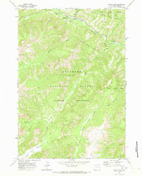
The Strawberry Butte quadrangle, scale 1:24,000, is a legacy map of the U.S. Geological Survey, made as part of the Montana Investigations Project to provide information on the stratigraphy, structure, and geologic history of the area. The quadrangle encompasses an area of about 132 km2 (51 mi2) in the southwest part of the Little Belt Mountains and is about 26 km (17 mi) north of White Sulphur Springs, county seat of Meagher County, Montana. Two contrasting geologic terranes form the area. The northern two-thirds of the quadrangle are underlain by Paleoproterozoic metagranite that contains some inclusions of metadiorite and biotite gneiss. A veneer of Middle Cambrian sedimentary rocks, including the Flathead Sandstone...
USGS Historical Quadrangle in GeoPDF.
As part of the Great Lakes Restoration Initiative, the U.S. Department of Agriculture, Natural Resources Conservation Service; U.S. Environmental Protection Agency; and the U.S. Geological Survey (USGS) have partnered to evaluate the impacts of implementing agricultural conservation practices focused on nutrient management. Monitoring methods have been designed to allow for rapid assessment of water-quality changes in response to conservation efforts by focusing on subsurface-tile drainage and direct surface runoff from fields—the major pathways for nonpoint-source pollution to enter streams. Monitoring stations were established at the field edge that measured runoff volume and enabled the collection of samples...
USGS Historical Quadrangle in GeoPDF.
|

|
