Filters
Date Range
Types
Contacts
Categories
Tag Types
Tag Schemes
|
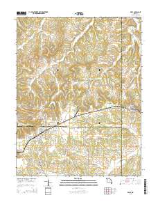
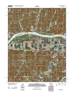
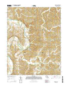
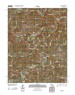
Layered GeoPDF 7.5 Minute Quadrangle Map. Layers of geospatial data include orthoimagery, roads, grids, geographic names, elevation contours, hydrography, and other selected map features.
Tags: 7.5 x 7.5 minute,
Belle, MO,
Downloadable Data,
EarthCover,
Gasconade, All tags...
GeoPDF,
Imagery and Base Maps,
Map,
Maries,
Missouri,
Osage,
Public Land Survey System,
U.S. National Grid,
US,
US Topo,
US Topo Historical,
United States,
boundary,
contour,
geographic names,
hydrography,
imageryBaseMapsEarthCover,
orthoimage,
structures,
topographic,
transportation,
woodland, Fewer tags
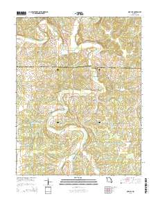
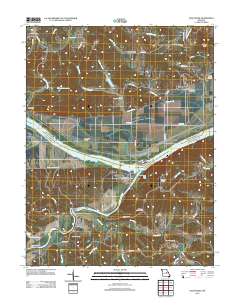
Layered GeoPDF 7.5 Minute Quadrangle Map. Layers of geospatial data include orthoimagery, roads, grids, geographic names, elevation contours, hydrography, and other selected map features.
Tags: 7.5 x 7.5 minute,
Crawford,
Downloadable Data,
EarthCover,
Gasconade, All tags...
GeoPDF,
Imagery and Base Maps,
Map,
Missouri,
Oak Hill, MO,
Public Land Survey System,
U.S. National Grid,
US,
US Topo,
US Topo Historical,
United States,
boundary,
contour,
geographic names,
hydrography,
imageryBaseMapsEarthCover,
orthoimage,
structures,
topographic,
transportation,
woodland, Fewer tags
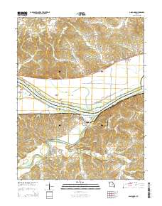
Layered GeoPDF 7.5 Minute Quadrangle Map. Layers of geospatial data include orthoimagery, roads, grids, geographic names, elevation contours, hydrography, and other selected map features.
Tags: 7.5 x 7.5 minute,
Downloadable Data,
EarthCover,
Fredericksburg, MO,
Gasconade, All tags...
GeoPDF,
Imagery and Base Maps,
Map,
Missouri,
Osage,
U.S. National Grid,
US,
US Topo,
US Topo Historical,
United States,
contour,
geographic names,
hydrography,
imageryBaseMapsEarthCover,
orthoimage,
structures,
topographic,
transportation, Fewer tags
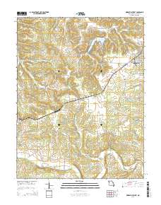
Layered GeoPDF 7.5 Minute Quadrangle Map. Layers of geospatial data include orthoimagery, roads, grids, geographic names, elevation contours, hydrography, and other selected map features.
Tags: 7.5 x 7.5 minute,
Downloadable Data,
EarthCover,
Gasconade,
GeoPDF, All tags...
Imagery and Base Maps,
Map,
Missouri,
Owensville West, MO,
U.S. National Grid,
US,
US Topo,
US Topo Historical,
United States,
contour,
geographic names,
hydrography,
imageryBaseMapsEarthCover,
orthoimage,
structures,
topographic,
transportation, Fewer tags

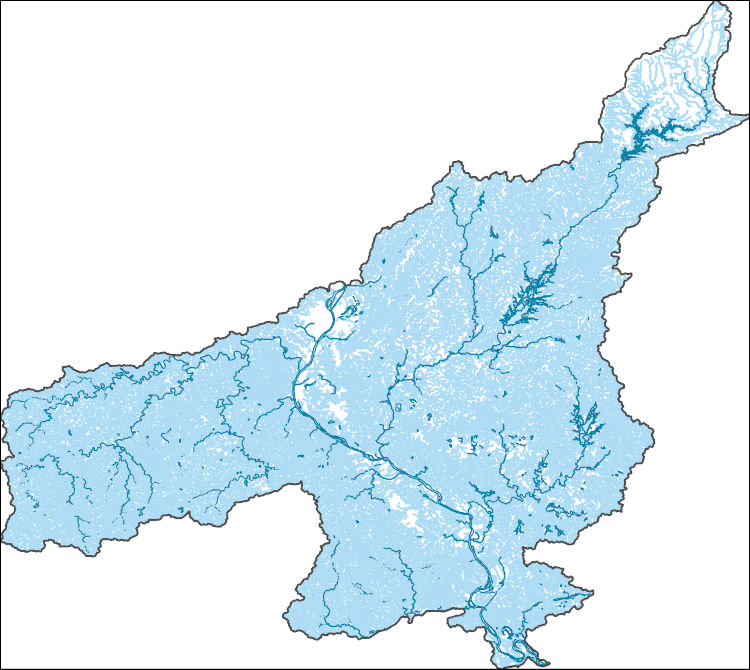
The Watershed Boundary Dataset (WBD) is a comprehensive aggregated collection of hydrologic unit data consistent with the national criteria for delineation and resolution. It defines the areal extent of surface water drainage to a point except in coastal or lake front areas where there could be multiple outlets as stated by the "Federal Standards and Procedures for the National Watershed Boundary Dataset (WBD)" "Standard" (https://pubs.usgs.gov/tm/11/a3/). Watershed boundaries are determined solely upon science-based hydrologic principles, not favoring any administrative boundaries or special projects, nor particular program or agency. This dataset represents the hydrologic unit boundaries to the 12-digit (6th level)...
Tags: 10-digit,
12-digit,
14-digit,
16-digit,
2-digit, All tags...
4-digit,
6-digit,
8-digit,
Adair,
Adams,
Albany,
Allen,
Anderson,
Andrew,
Antelope,
Appanoose,
Arapahoe,
Arthur,
Atchison,
Audrain,
Audubon,
Aurora,
Banner,
Barnes,
Barton,
Basin,
Bates,
Beadle,
Beaverhead,
Bennett,
Benton,
Big Horn,
Billings,
Blaine,
Bon Homme,
Boone,
Boulder,
Bourbon,
Bowman,
Box Butte,
Boyd,
Broadwater,
Brookings,
Broomfield,
Brown,
Brule,
Buchanan,
Buena Vista,
Buffalo,
Burke,
Burleigh,
Burt,
Butler,
Butte,
CO,
Caldwell,
Callaway,
Camden,
Campbell,
Carbon,
Carroll,
Carter,
Cascade,
Cass,
Cedar,
Chaffee,
Chariton,
Charles Mix,
Chase,
Cherokee,
Cherry,
Cheyenne,
Chouteau,
Christian,
Clark,
Clarke,
Clay,
Clear Creek,
Clinton,
Cloud,
Codington,
Coffey,
Cole,
Colfax,
Colorado,
Converse,
Cooper,
Corson,
Crawford,
Crook,
Cuming,
Custer,
Dade,
Dakota,
Dallas,
Daniels,
Daviess,
Davis,
Davison,
Dawes,
Dawson,
Day,
DeKalb,
Decatur,
Deer Lodge,
Dent,
Denver,
Deuel,
Dewey,
Dickey,
Dickinson,
Divide,
Dixon,
Dodge,
Doniphan,
Douglas,
Downloadable Data,
Dundy,
Dunn,
Eddy,
Edmunds,
El Paso,
Elbert,
Ellis,
Ellsworth,
Emmet,
Emmons,
Fall River,
Fallon,
Faulk,
Fergus,
Fillmore,
Flathead,
Foster,
Franklin,
Fremont,
Frontier,
Furnas,
Gage,
Gallatin,
Garden,
Garfield,
Gasconade,
Geary,
Gentry,
GeoPackage,
Gilpin,
Glacier,
Golden Valley,
Goshen,
Gosper,
Gove,
Graham,
Grand,
Granite,
Grant,
Greeley,
Greene,
Gregory,
Grundy,
Guthrie,
HU-2,
HU-2 Region,
HU2_10,
HUC,
Haakon,
Hall,
Hamilton,
Hamlin,
Hand,
Hanson,
Harding,
Harlan,
Harrison,
Hayes,
Henry,
Hettinger,
Hickory,
Hill,
Hitchcock,
Holt,
Hooker,
Hot Springs,
Howard,
Howell,
Hughes,
Hutchinson,
Hyde,
Hydrography,
Hydrologic Unit Code,
Hydrologic Units,
IA,
ID,
Ida,
Idaho,
Iowa,
Jackson,
Jefferson,
Jerauld,
Jewell,
Johnson,
Jones,
Judith Basin,
KS,
Kansas,
Kearney,
Keith,
Keya Paha,
Kidder,
Kimball,
Kingsbury,
Kit Carson,
Knox,
LaMoure,
Laclede,
Lafayette,
Lake,
Lancaster,
Lane,
Laramie,
Larimer,
Lawrence,
Leavenworth,
Lemhi,
Lewis and Clark,
Liberty,
Lincoln,
Linn,
Livingston,
Logan,
Loup,
Lucas,
Lyman,
Lyon,
MN,
MO,
MT,
Macon,
Madison,
Maries,
Marion,
Marshall,
McCone,
McCook,
McHenry,
McIntosh,
McKenzie,
McLean,
McPherson,
Meade,
Meagher,
Mellette,
Mercer,
Merrick,
Miami,
Miller,
Mills,
Miner,
Minnehaha,
Minnesota,
Missouri,
Mitchell,
Moniteau,
Monona,
Monroe,
Montana,
Montgomery,
Moody,
Morgan,
Morrill,
Morris,
Morton,
Mountrail,
Murray,
Musselshell,
ND,
NE,
Nance,
National Watershed Boundary Dataset (WBD),
National Watershed Boundary Dataset (WBD),
Natrona,
Nebraska,
Nemaha,
Ness,
Niobrara,
Nobles,
Nodaway,
North Dakota,
Norton,
Nuckolls,
O'Brien,
Oglala Lakota,
Oliver,
Open Geospatial Consortium GeoPackage 1.2,
Osage,
Osborne,
Osceola,
Otoe,
Ottawa,
Page,
Palo Alto,
Park,
Pawnee,
Pennington,
Perkins,
Petroleum,
Pettis,
Phelps,
Phillips,
Pierce,
Pipestone,
Platte,
Plymouth,
Polk,
Pondera,
Pottawatomie,
Pottawattamie,
Potter,
Powder River,
Powell,
Prairie,
Pulaski,
Putnam,
Randolph,
Ransom,
Ravalli,
Rawlins,
Ray,
Red Willow,
Region,
Republic,
Rice,
Richardson,
Richland,
Riley,
Ringgold,
Roberts,
Rock,
Rooks,
Roosevelt,
Rosebud,
Routt,
Rush,
Russell,
SD,
Sac,
Saline,
Sanborn,
Sargent,
Sarpy,
Saunders,
Schuyler,
Scott,
Scotts Bluff,
Sedgwick,
Seward,
Shawnee,
Shelby,
Sheridan,
Sherman,
Silver Bow,
Sioux,
Slope,
Smith,
South Dakota,
Spink,
St. Charles,
St. Clair,
St. Louis,
Stanley,
Stanton,
Stark,
Stillwater,
Stutsman,
Sub-basin,
Sub-region,
Sublette,
Subwatershed,
Sullivan,
Sully,
Summit,
Sweet Grass,
Sweetwater,
Taylor,
Teller,
Teton,
Texas,
Thayer,
Thomas,
Thurston,
Todd,
Toole,
Treasure,
Trego,
Tripp,
Turner,
US,
Union,
United States,
Valley,
Vernon,
WBD,
WY,
Wabaunsee,
Wallace,
Walworth,
Ward,
Warren,
Washakie,
Washington,
Watershed,
Watershed Boundary Dataset,
Wayne,
Webster,
Weld,
Wells,
Weston,
Wheatland,
Wheeler,
Wibaux,
Wichita,
Williams,
Woodbury,
Worth,
Wright,
Wyandotte,
Wyoming,
Yankton,
Yellowstone,
York,
Yuma,
Ziebach,
inlandWaters, Fewer tags

The Geographic Names Information System (GNIS) is the Federal standard for geographic nomenclature. The U.S. Geological Survey developed the GNIS for the U.S. Board on Geographic Names, a Federal inter-agency body chartered by public law to maintain uniform feature name usage throughout the Government and to promulgate standard names to the public. The GNIS is the official repository of domestic geographic names data; the official vehicle for geographic names use by all departments of the Federal Government; and the source for applying geographic names to Federal electronic and printed products of all types.
Tags: Adair,
Andrew,
Antarctica,
Antarctica,
Atchison, All tags...
Audrain,
BGN,
Barry,
Barton,
Bates,
Benton,
Board on Geographic Names,
Bollinger,
Boone,
Borough,
Buchanan,
Butler,
Caldwell,
Callaway,
Camden,
Cape Girardeau,
Carroll,
Carter,
Cass,
Cedar,
Census Area,
Chariton,
Christian,
Clark,
Clay,
Clinton,
Cole,
Commonwealth,
Cooper,
County,
Crawford,
Dade,
Dallas,
Daviess,
DeKalb,
Dent,
District,
Douglas,
Downloadable Data,
Dunklin,
Esri File GeoDatabase 10,
Feature class,
Feature coordinates,
Feature county,
Feature description,
Feature designation,
Feature history,
Feature indentification,
Feature name,
Feature state,
FileGDB,
Franklin,
GNIS,
Gasconade,
Gentry,
Geographic Names,
Geographic Names Full Model,
Geographic Names Information System,
Geographic feature,
Geographic name,
Geographical feature,
Geographical name,
Greene,
Grundy,
Harrison,
Henry,
Hickory,
Holt,
Howard,
Howell,
Iron,
Jackson,
Jasper,
Jefferson,
Johnson,
Knox,
Laclede,
Lafayette,
Lawrence,
Lewis,
Lincoln,
Linn,
Livingston,
MO,
Macon,
Madison,
Maries,
Marion,
McDonald,
Mercer,
Miller,
Mississippi,
Missouri,
Moniteau,
Monroe,
Montgomery,
Morgan,
Municipio,
National Geographic Names Information System (GNIS),
National Geographic Names Information System (GNIS),
New Madrid,
Newton,
Nodaway,
Official feature name,
Oregon,
Osage,
Outlying Area,
Ozark,
Parish,
Pemiscot,
Perry,
Pettis,
Phelps,
Pike,
Place name,
Platte,
Polk,
Populated Place,
Pulaski,
Putnam,
Ralls,
Randolph,
Ray,
Reynolds,
Ripley,
Saline,
Schuyler,
Scotland,
Scott,
Shannon,
Shelby,
St. Charles,
St. Clair,
St. Francois,
St. Louis,
State,
Ste. Genevieve,
Stoddard,
Stone,
Sullivan,
Taney,
Territories,
Territory,
Texas,
Topographic Map,
U.S. Board on Geographic Names,
U.S. Geological Survey,
US,
USA,
USBGN,
USGS,
United States,
United States,
United States,
Variant name,
Vernon,
Warren,
Washington,
Wayne,
Webster,
Worth,
Wright,
antarctic,
database,
economy,
environment,
feature,
gazetteer,
geographic,
geographic names,
geographical,
geography,
geospatial,
imageryBaseMapsEarthCover,
inlandWaters,
location,
map,
name,
place,
placename,
society,
structure,
topographic map,
toponymy, Fewer tags
Layered GeoPDF 7.5 Minute Quadrangle Map. Layers of geospatial data include orthoimagery, roads, grids, geographic names, elevation contours, hydrography, and other selected map features.
Tags: 7.5 x 7.5 minute,
Callaway,
Downloadable Data,
EarthCover,
Gasconade, All tags...
GeoPDF,
Imagery and Base Maps,
Map,
Missouri,
Montgomery,
Morrison, MO,
Osage,
Public Land Survey System,
U.S. National Grid,
US,
US Topo,
US Topo Historical,
United States,
boundary,
contour,
geographic names,
hydrography,
imageryBaseMapsEarthCover,
orthoimage,
structures,
topographic,
transportation,
woodland, Fewer tags
USGS Historical Quadrangle in GeoPDF.
Tags: 7.5 x 7.5 minute,
Downloadable Data,
Gasconade,
GeoPDF,
GeoTIFF, All tags...
Historical Topographic Maps,
Historical Topographic Maps 7.5 x 7.5 Minute Map Series,
MO,
Map,
imageryBaseMapsEarthCover, Fewer tags
The Watershed Boundary Dataset (WBD) is a comprehensive aggregated collection of hydrologic unit data consistent with the national criteria for delineation and resolution. It defines the areal extent of surface water drainage to a point except in coastal or lake front areas where there could be multiple outlets as stated by the "Federal Standards and Procedures for the National Watershed Boundary Dataset (WBD)" "Standard" (https://pubs.usgs.gov/tm/11/a3/). Watershed boundaries are determined solely upon science-based hydrologic principles, not favoring any administrative boundaries or special projects, nor particular program or agency. This dataset represents the hydrologic unit boundaries to the 12-digit (6th level)...
Tags: 10-digit,
12-digit,
14-digit,
16-digit,
2-digit, All tags...
4-digit,
6-digit,
8-digit,
Adair,
Adams,
Aitkin,
Alexander,
Allamakee,
Anoka,
Appanoose,
Ashland,
Audrain,
Audubon,
Ballard,
Barron,
Basin,
Bayfield,
Becker,
Beltrami,
Benton,
Berrien,
Big Stone,
Black Hawk,
Blue Earth,
Bollinger,
Bond,
Boone,
Bremer,
Brookings,
Brown,
Buchanan,
Buena Vista,
Buffalo,
Bureau,
Burnett,
Butler,
Calhoun,
Callaway,
Cape Girardeau,
Carlton,
Carroll,
Carver,
Cass,
Cedar,
Cerro Gordo,
Champaign,
Chickasaw,
Chippewa,
Chisago,
Christian,
Clark,
Clarke,
Clay,
Clayton,
Clearwater,
Clinton,
Codington,
Coles,
Columbia,
Cook,
Cottonwood,
Crawford,
Crow Wing,
Dakota,
Dallas,
Dane,
Davis,
Day,
De Witt,
DeKalb,
Delaware,
Dent,
Des Moines,
Deuel,
Dickinson,
Dodge,
Douglas,
Downloadable Data,
DuPage,
Dubuque,
Dunn,
Eau Claire,
Effingham,
Elkhart,
Emmet,
Faribault,
Fayette,
Fillmore,
Floyd,
Fond du Lac,
Ford,
Forest,
Franklin,
Freeborn,
Fulton,
Gasconade,
GeoPackage,
Gogebic,
Goodhue,
Grant,
Green,
Green Lake,
Greene,
Grundy,
Guthrie,
HU-2,
HU-2 Region,
HU2_07,
HUC,
Hamilton,
Hancock,
Hardin,
Henderson,
Hennepin,
Henry,
Houston,
Howard,
Hubbard,
Humboldt,
Hydrography,
Hydrologic Unit Code,
Hydrologic Units,
IA,
IL,
IN,
Illinois,
Indiana,
Iowa,
Iowa,
Iron,
Iroquois,
Isanti,
Itasca,
Jackson,
Jasper,
Jefferson,
Jersey,
Jo Daviess,
Johnson,
Jones,
Juneau,
KY,
Kanabec,
Kandiyohi,
Kane,
Kankakee,
Kendall,
Kenosha,
Kentucky,
Keokuk,
Knox,
Kosciusko,
Kossuth,
La Crosse,
LaPorte,
LaSalle,
Lac qui Parle,
Lafayette,
Lake,
Langlade,
Le Sueur,
Lee,
Lewis,
Lincoln,
Linn,
Livingston,
Logan,
Louisa,
Lucas,
Lyon,
MI,
MN,
MO,
Macon,
Macoupin,
Madison,
Mahaska,
Marathon,
Maries,
Marion,
Marquette,
Marshall,
Martin,
Mason,
McDonough,
McHenry,
McLean,
McLeod,
Meeker,
Menard,
Mercer,
Michigan,
Mille Lacs,
Milwaukee,
Minnesota,
Mississippi,
Missouri,
Mitchell,
Monroe,
Montgomery,
Morgan,
Morrison,
Moultrie,
Mower,
Murray,
Muscatine,
ND,
National Watershed Boundary Dataset (WBD),
National Watershed Boundary Dataset (WBD),
Newton,
Nicollet,
Nobles,
North Dakota,
Ogle,
Olmsted,
Oneida,
Open Geospatial Consortium GeoPackage 1.2,
Osage,
Otter Tail,
Palo Alto,
Peoria,
Pepin,
Perry,
Phelps,
Piatt,
Pierce,
Pike,
Pine,
Pipestone,
Pocahontas,
Polk,
Pope,
Portage,
Porter,
Poweshiek,
Price,
Pulaski,
Putnam,
Racine,
Ralls,
Ramsey,
Randolph,
Redwood,
Region,
Renville,
Reynolds,
Rice,
Richland,
Roberts,
Rock,
Rock Island,
Rusk,
SD,
Sac,
Sangamon,
Sauk,
Sawyer,
Schuyler,
Scotland,
Scott,
Shawano,
Shelby,
Sherburne,
Sibley,
South Dakota,
St. Charles,
St. Clair,
St. Croix,
St. Francois,
St. Joseph,
St. Louis,
Stark,
Starke,
Ste. Genevieve,
Stearns,
Steele,
Stephenson,
Stevens,
Story,
Sub-basin,
Sub-region,
Subwatershed,
Swift,
Tama,
Taylor,
Tazewell,
Texas,
Todd,
Traverse,
Trempealeau,
US,
Union,
United States,
Van Buren,
Vermilion,
Vernon,
Vilas,
WBD,
WI,
Wabasha,
Wadena,
Walworth,
Wapello,
Warren,
Waseca,
Washburn,
Washington,
Watershed,
Watershed Boundary Dataset,
Watonwan,
Waukesha,
Waushara,
Wayne,
Webster,
White,
Whiteside,
Will,
Williamson,
Winnebago,
Winneshiek,
Winona,
Wisconsin,
Wood,
Woodford,
Worth,
Wright,
Yellow Medicine,
inlandWaters, Fewer tags
The National Hydrography Dataset (NHD) is a feature-based database that interconnects and uniquely identifies the stream segments or reaches that make up the nation's surface water drainage system. NHD data was originally developed at 1:100,000-scale and exists at that scale for the whole country. This high-resolution NHD, generally developed at 1:24,000/1:12,000 scale, adds detail to the original 1:100,000-scale NHD. (Data for Alaska, Puerto Rico and the Virgin Islands was developed at high-resolution, not 1:100,000 scale.) Local resolution NHD is being developed where partners and data exist. The NHD contains reach codes for networked features, flow direction, names, and centerline representations for areal water...
Tags: Administrative watershed units,
Administrative watershed units,
Area of Complex Channels,
Area to be submerged,
Audrain, All tags...
Basin,
Basin,
Bay/Inlet,
Boone,
Boundaries,
Boundary,
Bridge,
Callaway,
Canal/Ditch,
Chariton,
Coastline,
Cole,
Connector,
Cooper,
Dam/Weir,
Downloadable Data,
Drainage areas for surface water,
Drainageway,
Estuary,
Flow direction network,
Flume,
ForeShore,
Gaging Station,
Gasconade,
Gate,
GeoPackage,
HU-8,
HU-8 Subbasin,
HU10,
HU12,
HU14,
HU16,
HU2,
HU4,
HU6,
HU8,
HU8_10300102,
HUC,
Hazard Zone,
Howard,
Hydrographic,
Hydrography,
Hydrography,
Hydrography,
Hydrologic Unit Code,
Hydrologic Units,
Ice mass,
Inundation Area,
Levee,
Line,
Lock Chamber,
MO,
Marsh,
Miller,
Missouri,
Moniteau,
Montgomery,
Morgan,
National Hydrography Dataset (NHD),
National Hydrography Dataset (NHD) Best Resolution,
National Hydrography Dataset (NHD) Best Resolution,
Nonearthen Shore,
Open Geospatial Consortium GeoPackage 1.2,
Orthoimage,
Osage,
Playa,
Point,
PointEvent,
Pond,
Randolph,
Rapids,
Rapids,
Reach,
Reach code,
Reef,
Region,
Reservoir,
Rock,
Saline,
Sea/Ocean,
Sink/Rise,
Sounding Datum Line,
Special Use Zone,
Special Use Zone Limit,
Spillway,
Stream,
Stream/River,
Sub-basin,
Sub-region,
Subbasin,
Submerged Stream,
Subregion,
Subwatershed,
Surface water systems,
Swamp,
Topographic,
Tunnel,
US,
Underground Conduit,
United States,
WBD,
WBD,
Wall,
Wash,
Water Intake Outflow,
Waterfall,
Watershed,
Watershed Boundaries,
Watershed Boundary Dataset,
Watershed Boundary Dataset,
Well,
artificial path,
boundaries,
dams,
drainage systems and characteristics,
inlandWaters,
lakes,
ngda,
rivers, Fewer tags
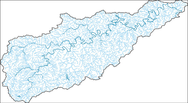
The National Hydrography Dataset (NHD) is a feature-based database that interconnects and uniquely identifies the stream segments or reaches that make up the nation's surface water drainage system. NHD data was originally developed at 1:100,000-scale and exists at that scale for the whole country. This high-resolution NHD, generally developed at 1:24,000/1:12,000 scale, adds detail to the original 1:100,000-scale NHD. (Data for Alaska, Puerto Rico and the Virgin Islands was developed at high-resolution, not 1:100,000 scale.) Local resolution NHD is being developed where partners and data exist. The NHD contains reach codes for networked features, flow direction, names, and centerline representations for areal water...
Tags: Administrative watershed units,
Administrative watershed units,
Area of Complex Channels,
Area to be submerged,
Basin, All tags...
Basin,
Bay/Inlet,
Boundaries,
Boundary,
Bridge,
Canal/Ditch,
Coastline,
Connector,
Crawford,
Dam/Weir,
Downloadable Data,
Drainage areas for surface water,
Drainageway,
Estuary,
Flow direction network,
Flume,
ForeShore,
Franklin,
Gaging Station,
Gasconade,
Gate,
GeoPackage,
HU-8,
HU-8 Subbasin,
HU10,
HU12,
HU14,
HU16,
HU2,
HU4,
HU6,
HU8,
HU8_07140103,
HUC,
Hazard Zone,
Hydrographic,
Hydrography,
Hydrography,
Hydrography,
Hydrologic Unit Code,
Hydrologic Units,
Ice mass,
Inundation Area,
Levee,
Line,
Lock Chamber,
MO,
Maries,
Marsh,
Missouri,
National Hydrography Dataset (NHD),
National Hydrography Dataset (NHD) Best Resolution,
National Hydrography Dataset (NHD) Best Resolution,
Nonearthen Shore,
Open Geospatial Consortium GeoPackage 1.2,
Orthoimage,
Osage,
Phelps,
Playa,
Point,
PointEvent,
Pond,
Rapids,
Rapids,
Reach,
Reach code,
Reef,
Region,
Reservoir,
Rock,
Sea/Ocean,
Sink/Rise,
Sounding Datum Line,
Special Use Zone,
Special Use Zone Limit,
Spillway,
Stream,
Stream/River,
Sub-basin,
Sub-region,
Subbasin,
Submerged Stream,
Subregion,
Subwatershed,
Surface water systems,
Swamp,
Topographic,
Tunnel,
US,
Underground Conduit,
United States,
WBD,
WBD,
Wall,
Wash,
Water Intake Outflow,
Waterfall,
Watershed,
Watershed Boundaries,
Watershed Boundary Dataset,
Watershed Boundary Dataset,
Well,
artificial path,
boundaries,
dams,
drainage systems and characteristics,
inlandWaters,
lakes,
ngda,
rivers, Fewer tags
The National Hydrography Dataset (NHD) is a feature-based database that interconnects and uniquely identifies the stream segments or reaches that make up the nation's surface water drainage system. NHD data was originally developed at 1:100,000-scale and exists at that scale for the whole country. This high-resolution NHD, generally developed at 1:24,000/1:12,000 scale, adds detail to the original 1:100,000-scale NHD. (Data for Alaska, Puerto Rico and the Virgin Islands was developed at high-resolution, not 1:100,000 scale.) Local resolution NHD is being developed where partners and data exist. The NHD contains reach codes for networked features, flow direction, names, and centerline representations for areal water...
Tags: Administrative watershed units,
Administrative watershed units,
Alexander,
Area of Complex Channels,
Area to be submerged, All tags...
Ballard,
Basin,
Basin,
Bay/Inlet,
Bollinger,
Bond,
Boundaries,
Boundary,
Bridge,
Canal/Ditch,
Cape Girardeau,
Champaign,
Christian,
Clinton,
Coastline,
Coles,
Connector,
Crawford,
Dam/Weir,
Dent,
Douglas,
Downloadable Data,
Drainage areas for surface water,
Drainageway,
Effingham,
Estuary,
Fayette,
Flow direction network,
Flume,
ForeShore,
Franklin,
Gaging Station,
Gasconade,
Gate,
GeoPackage,
HU-4,
HU-4 Subregion,
HU10,
HU12,
HU14,
HU16,
HU2,
HU4,
HU4_0714,
HU6,
HU8,
HUC,
Hamilton,
Hazard Zone,
Hydrographic,
Hydrography,
Hydrography,
Hydrography,
Hydrologic Unit Code,
Hydrologic Units,
IL,
Ice mass,
Illinois,
Inundation Area,
Iron,
Jackson,
Jefferson,
Johnson,
KY,
Kentucky,
Levee,
Line,
Lock Chamber,
MO,
Macon,
Macoupin,
Madison,
Maries,
Marion,
Marsh,
Mississippi,
Missouri,
Monroe,
Montgomery,
Moultrie,
National Hydrography Dataset (NHD),
National Hydrography Dataset (NHD) Best Resolution,
National Hydrography Dataset (NHD) Best Resolution,
Nonearthen Shore,
Open Geospatial Consortium GeoPackage 1.2,
Orthoimage,
Osage,
Perry,
Phelps,
Piatt,
Playa,
Point,
PointEvent,
Pond,
Pulaski,
Randolph,
Rapids,
Rapids,
Reach,
Reach code,
Reef,
Region,
Reservoir,
Reynolds,
Rock,
Scott,
Sea/Ocean,
Shelby,
Sink/Rise,
Sounding Datum Line,
Special Use Zone,
Special Use Zone Limit,
Spillway,
St. Charles,
St. Clair,
St. Francois,
St. Louis,
Ste. Genevieve,
Stream,
Stream/River,
Sub-basin,
Sub-region,
Subbasin,
Submerged Stream,
Subregion,
Subwatershed,
Surface water systems,
Swamp,
Texas,
Topographic,
Tunnel,
US,
Underground Conduit,
Union,
United States,
WBD,
WBD,
Wall,
Wash,
Washington,
Water Intake Outflow,
Waterfall,
Watershed,
Watershed Boundaries,
Watershed Boundary Dataset,
Watershed Boundary Dataset,
Wayne,
Well,
Williamson,
artificial path,
boundaries,
dams,
drainage systems and characteristics,
inlandWaters,
lakes,
ngda,
rivers, Fewer tags

These data are high-resolution bathymetry (riverbed elevation) in ASCII format, generated from hydrographic surveys near six highway bridge structures over the Gasconade River in central Missouri. These sites were surveyed in June 2017 to help identify possible effects from extreme flooding on May 1-2, 2017. At the five downstream sites, hydrographic data were collected using a high-resolution multibeam echosounder mapping system (MBMS), which consists of a multibeam echosounder (MBES) and an inertial navigation system (INS) mounted on a marine survey vessel. Data were collected as the vessel traversed the river along planned survey lines distributed throughout the reach. Data collection software integrated and...
Categories: Data Release - Revised;
Tags: ASCII,
Bathymetry,
Gasconade,
Gasconade River,
Geology, All tags...
Geomorphology,
Jerome,
MO,
Missouri,
Mount Sterling,
Multibeam,
Remote Sensing,
Rich Fountain,
U.S. Geological Survey,
USA,
USGS,
USGS Science Data Catalog (SDC),
Vienna,
Water Depth,
Water Resources,
XYZ,
elevation,
geoscientificInformation,
imageryBaseMapsEarthCover,
inland waters,
inlandWaters,
inlandWaters,
location,
oceans,
structure, Fewer tags
Layered GeoPDF 7.5 Minute Quadrangle Map. Layers of geospatial data include orthoimagery, roads, grids, geographic names, elevation contours, hydrography, and other selected map features.
Tags: 7.5 x 7.5 minute,
Callaway,
Downloadable Data,
EarthCover,
Gasconade, All tags...
GeoPDF,
Imagery and Base Maps,
Map,
Missouri,
Montgomery,
Morrison, MO,
Osage,
U.S. National Grid,
US,
US Topo,
US Topo Historical,
United States,
contour,
geographic names,
hydrography,
imageryBaseMapsEarthCover,
orthoimage,
structures,
topographic,
transportation, Fewer tags
Layered GeoPDF 7.5 Minute Quadrangle Map. Layers of geospatial data include orthoimagery, roads, grids, geographic names, elevation contours, hydrography, and other selected map features.
Tags: 7.5 x 7.5 minute,
Downloadable Data,
EarthCover,
Gasconade,
GeoPDF, All tags...
Imagery and Base Maps,
Map,
Missouri,
Pershing, MO,
Public Land Survey System,
U.S. National Grid,
US,
US Topo,
US Topo Historical,
United States,
boundary,
contour,
geographic names,
hydrography,
imageryBaseMapsEarthCover,
orthoimage,
structures,
topographic,
transportation,
woodland, Fewer tags
Layered GeoPDF 7.5 Minute Quadrangle Map. Layers of geospatial data include orthoimagery, roads, grids, geographic names, elevation contours, hydrography, and other selected map features.
Tags: 7.5 x 7.5 minute,
Crawford,
Downloadable Data,
EarthCover,
Gasconade, All tags...
GeoPDF,
Imagery and Base Maps,
Map,
Missouri,
Phelps,
Redbird, MO,
U.S. National Grid,
US,
US Topo,
US Topo Historical,
United States,
contour,
geographic names,
hydrography,
imageryBaseMapsEarthCover,
orthoimage,
structures,
topographic,
transportation, Fewer tags
Layered GeoPDF 7.5 Minute Quadrangle Map. Layers of geospatial data include orthoimagery, roads, grids, geographic names, elevation contours, hydrography, and other selected map features.
Tags: 7.5 x 7.5 minute,
Downloadable Data,
EarthCover,
Gasconade,
Gasconade, MO, All tags...
GeoPDF,
Imagery and Base Maps,
Map,
Missouri,
Montgomery,
Public Land Survey System,
U.S. National Grid,
US,
US Topo,
US Topo Historical,
United States,
boundary,
contour,
geographic names,
hydrography,
imageryBaseMapsEarthCover,
orthoimage,
structures,
topographic,
transportation,
woodland, Fewer tags

These data are currently under revision and will be available again in a few weeks. Please check back in April 2019 or contact Richard J Huizinga for more information. These data are high-resolution bathymetry (riverbed elevation) in ASCII format, generated from hydrographic surveys near six highway bridge structures over the Gasconade River in central Missouri. These sites were surveyed in June 2017 to help identify possible effects from extreme flooding on May 1-2, 2017. At the five downstream sites, hydrographic data were collected using a high-resolution multibeam echosounder mapping system (MBMS), which consists of a multibeam echosounder (MBES) and an inertial navigation system (INS) mounted on a marine survey...
Tags: ASCII,
Bathymetry,
Gasconade,
Gasconade River,
Geology, All tags...
Geomorphology,
Jerome,
MO,
Missouri,
Mount Sterling,
Multibeam,
Remote Sensing,
Rich Fountain,
U.S. Geological Survey,
USA,
USGS,
USGS Science Data Catalog (SDC),
Vienna,
Water Depth,
Water Resources,
XYZ,
bathymetry,
elevation,
geoscientificInformation,
imageryBaseMapsEarthCover,
inland waters,
inlandWaters,
inlandWaters,
location,
oceans,
structure, Fewer tags
Layered GeoPDF 7.5 Minute Quadrangle Map. Layers of geospatial data include orthoimagery, roads, grids, geographic names, elevation contours, hydrography, and other selected map features.
Tags: 7.5 x 7.5 minute,
Downloadable Data,
EarthCover,
Gasconade,
GeoPDF, All tags...
Imagery and Base Maps,
Map,
Missouri,
Owensville West, MO,
Public Land Survey System,
U.S. National Grid,
US,
US Topo,
US Topo Historical,
United States,
boundary,
contour,
geographic names,
hydrography,
imageryBaseMapsEarthCover,
orthoimage,
structures,
topographic,
transportation,
woodland, Fewer tags
|
|

