Filters: Tags: Standing Rock Indian Reservation (X)
4 results (13ms)|
Filters
Date Range
Contacts
Categories Tag Types Tag Schemes |
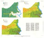
These data were released prior to the October 1, 2016 effective date for the USGS’s policy dictating the review, approval, and release of scientific data as referenced in USGS Survey Manual Chapter 502.8 Fundamental Science Practices: Review and Approval of Scientific Data for Release. This coverage contains information about the probability of obtaining a water supply within the Standing Rock Indian Reservation, Sioux County, North Dakota, and Corson County, South Dakota. The digital data were produced by the U.S. Geological Survey (USGS) in cooperation with the U.S. Environmental Protection Agency. The possibility of obtaining adequate supplies of good quality water from surficial deposits generally is limited...
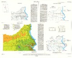
This data release includes text files of well data and shapefiles of potentiometric contours of the Fort Union, Hell Creek, and Fox Hills aquifers within the Standing Rock Reservation. The data accompanies a USGS scientific investigations map from Anderson and Lundgren (2024). The Standing Rock Sioux Tribe (the Tribe) of North and South Dakota and the U.S. Geological Survey (USGS) completed a comprehensive assessment of groundwater resources within the Standing Rock Reservation.Generalized potentiometric surfaces of the Fort Union, Hell Creek, and Fox Hills aquifers were constructed to assess the groundwater resources of the Standing Rock Reservation. Water-level data from the U.S. Geological Survey Groundwater...
These data were released prior to the October 1, 2016 effective date for the USGS’s policy dictating the review, approval, and release of scientific data as referenced in USGS Survey Manual Chapter 502.8 Fundamental Science Practices: Review and Approval of Scientific Data for Release. This coverage contains information about the western limit of glaciation within the Standing Rock Indian Reservation, Sioux County, North Dakota, and Corson County, South Dakota. The digital data were produced by the U.S. Geological Survey (USGS) in cooperation with the U.S. Environmental Protection Agency. Figure 5 in Howells (1982) was scanned and digitized on-screen to create this coverage. See cross reference information for...
These data were released prior to the October 1, 2016 effective date for the USGS’s policy dictating the review, approval, and release of scientific data as referenced in USGS Survey Manual Chapter 502.8 Fundamental Science Practices: Review and Approval of Scientific Data for Release. This coverage contains information about the buried valleys within the Standing Rock Indian Reservation, Sioux County, North Dakota, and Corson County, South Dakota. The delineation of the buried valleys was included as part of the surficial geology map (figure 5) created by Howells (1982). The digital data were produced by the U.S. Geological Survey (USGS) in cooperation with the U.S. Environmental Protection Agency. Figure 5 in...
Categories: pre-SM502.8;
Tags: Corson County, South Dakota,
NSDI,
North Dakota,
Sioux County, North Dakota,
South Dakota,
|

|
