Filters
Date Types (for Date Range)
Extensions
Types
Contacts
Categories
Tag Types
Tag Schemes
|

This coverage includes arcs, polygons and polygon labels that describe U.S. Geological Survey defined geologic provinces of Europe including Turkey. (Albania, Andorra, Austria, Belgium, Bosnia and Herzegovina, Bulgaria, Croatia, Cyprus, Czech Republic, Denmark, Finland, France, Germany, Greece, Hungary, Iceland, Ireland, Italy, Liechtenstein, Luxembourg, The Former Yugoslav Republic of Macedonia, Malta, Monaco, Netherlands, Norway, Poland, Portugal, Romania, San Marino, Serbia and Montenegro, Slovakia, Slovenia, Spain, Sweden, Switzerland, Turkey, United Kingdom and Vatican City.) Each province has a set of geologic characteristics distinguishing it from surrounding provinces. These characteristics may include the...
Categories: Data,
pre-SM502.8;
Types: Downloadable,
Map Service,
OGC WFS Layer,
OGC WMS Layer,
Shapefile;
Tags: AL,
AN,
AU,
Adana/Sivas, Province 2079,
Adriatic Basin, Province 4058, All tags...
Aegean, Province 4075,
Albania,
Alentejo-Guadalquivir Basin, Province 4077,
Alps, Province 4051,
Andalucia, Province 4088,
Andorra,
Anglo-Dutch Basin, Province 4036,
Anglo-Paris Basin, Province 4040,
Apulia Platform, Province 4059,
Aquitaine Basin, Province 4045,
Araks, Province 2080,
Armoricia, Province 4041,
Austria,
BE,
BK,
BU,
Baltic Depression, Province 4021,
Baltic Shield-Norwegian Caledonides, Province 4016,
Barents Continental Slope, Province 4013,
Belgium,
Belorussian-Voronezh High, Province 1004,
Betic Zone, Province 4078,
Black Sea Continental Slope, Province 1107,
Bohemia, Province 4046,
Bosnia and Herzegovina,
Bresse Depression, Province 4054,
Bulgaria,
CY,
Carpathian-Balkanian Basin, Province 4061,
Corsican-Sardinian Basins, Province 4067,
Crete, Province 4076,
Croatia,
Cyprus,
Czech Republic,
DA,
Denmark,
Dinaric Alps, Province 4071,
Dobrogea Foreland, Province 1103,
Dobrogean Orogen, Province 4063,
EI,
EZ,
Earth Science,
Economic geology,
Euphrates/Mardin, Province 2075,
Europe,
FI,
FO,
FR,
Faeroes-Shetland-Orkney Basin, Province 4019,
Faroe Islands,
Fennoscandian Border-Danish-Polish Margin, Province 4022,
Finland,
France,
GI,
GK,
GM,
GR,
Galician Basin, Province 4073,
Gas,
Geologic province,
Geology,
German-Polish Basin, Province 4033,
Germany,
Gibraltar,
Greece,
Guernsey,
HR,
HU,
Haleb, Province 2076,
Hammerfest-Varanger Basin, Province 4015,
Hatton-Rockall Basin, Province 4020,
Horda-Norwegian-Danish Basin, Province 4023,
Hungary,
IC,
IM,
IT,
Iberian Massif, Province 4072,
Iberic Cordillera, Province 4083,
Iceland,
Ireland,
Ireland-Scotland Platform, Province 4026,
Irish Sea, Province 4030,
Isle of Man,
Italy,
JE,
Jersey,
Jura, Province 4052,
Kardiff/Menders Massif, Province 2084,
Kola Monocline-Finnmark Platform, Province 1051,
LO,
LS,
LU,
Lesser Caucasus, Province 2081,
Liechtenstein,
Lion-Camargue, Province 4056,
London-Brabant Platform, Province 4037,
Lusitanian Basin, Province 4074,
Luxembourg,
MK,
MN,
MW,
Malta,
Massif Central, Province 4043,
Mediterranean Basin, Province 2070,
Mid-North Sea High, Province 4028,
Midland Valley-Forth Approaches Basin, Province 4027,
Molasse Basin, Province 4049,
Monaco,
Munsterland Basin, Province 4038,
NL,
NO,
Natural Gas,
Natural Resources,
Natural gas resources,
Netherlands,
North Carpathian Basin, Province 4047,
North Sea Graben, Province 4025,
Northwest German Basin, Province 4035,
Norway,
Oil,
Oil,
Oil sand resources,
Oil shale resources,
PL,
PO,
Pannonian Basin, Province 4048,
Pelagian Basin, Province 2048,
Petroleum,
Po Basin, Province 4060,
Poland,
Portugal,
Provence Basin, Province 4068,
Pyrenean Foothills-Ebro Basin, Province 4044,
RO,
Resource Assessment,
Rhine Graben, Province 4055,
Rif Basin, Province 2072,
Romania,
Russian Craton Margin, Province 1011,
SI,
SM,
SP,
SR,
SV,
SW,
SZ,
San Marino,
Serbia and Montenegro,
Sicily, Province 4066,
Slovakia,
Slovenia,
Southwest German Basin, Province 4039,
Spain,
Spanish Trough-Cantabrian Zone, Province 4070,
Svalbard,
Sweden,
Switzerland,
TU,
Tajo-Duero Basin, Province 4082,
The Former Yugoslav Republic of Macedonia,
Thrace/Samsun, Province 2085,
Trans-Graben, Province 4053,
Transylvanian Basin, Province 4057,
Troms-Bjornoya, Province 4014,
Turkey,
Tuscany-Latium-Paola, Province 4062,
Tuz/Corum, Province 2083,
Tyrrhenian Basin, Province 4069,
U.S. Geological Survey,
UK,
USGS,
USGS Science Data Catalog (SDC),
Ukrainian Shield, Province 1013,
United Kingdom,
VT,
Vatican City,
Vestford-Helgeland, Province 4017,
West Black Sea Basin, Province 4064,
Zagros Fold Belt, Province 2030,
Zagros Thrust Zone, Province 2031,
environment,
europe,
geoscientificInformation,
oilgas,
wep,
worldgeologicmaps, Fewer tags

The Watershed Boundary Dataset (WBD) is a comprehensive aggregated collection of hydrologic unit data consistent with the national criteria for delineation and resolution. It defines the areal extent of surface water drainage to a point except in coastal or lake front areas where there could be multiple outlets as stated by the "Federal Standards and Procedures for the National Watershed Boundary Dataset (WBD)" "Standard" (https://pubs.usgs.gov/tm/11/a3/). Watershed boundaries are determined solely upon science-based hydrologic principles, not favoring any administrative boundaries or special projects, nor particular program or agency. This dataset represents the hydrologic unit boundaries to the 12-digit (6th level)...
Tags: 10-digit,
12-digit,
14-digit,
16-digit,
2-digit, All tags...
4-digit,
6-digit,
8-digit,
Adair,
Adams,
Albany,
Allen,
Anderson,
Andrew,
Antelope,
Appanoose,
Arapahoe,
Arthur,
Atchison,
Audrain,
Audubon,
Aurora,
Banner,
Barnes,
Barton,
Basin,
Bates,
Beadle,
Beaverhead,
Bennett,
Benton,
Big Horn,
Billings,
Blaine,
Bon Homme,
Boone,
Boulder,
Bourbon,
Bowman,
Box Butte,
Boyd,
Broadwater,
Brookings,
Broomfield,
Brown,
Brule,
Buchanan,
Buena Vista,
Buffalo,
Burke,
Burleigh,
Burt,
Butler,
Butte,
CO,
Caldwell,
Callaway,
Camden,
Campbell,
Carbon,
Carroll,
Carter,
Cascade,
Cass,
Cedar,
Chaffee,
Chariton,
Charles Mix,
Chase,
Cherokee,
Cherry,
Cheyenne,
Chouteau,
Christian,
Clark,
Clarke,
Clay,
Clear Creek,
Clinton,
Cloud,
Codington,
Coffey,
Cole,
Colfax,
Colorado,
Converse,
Cooper,
Corson,
Crawford,
Crook,
Cuming,
Custer,
Dade,
Dakota,
Dallas,
Daniels,
Daviess,
Davis,
Davison,
Dawes,
Dawson,
Day,
DeKalb,
Decatur,
Deer Lodge,
Dent,
Denver,
Deuel,
Dewey,
Dickey,
Dickinson,
Divide,
Dixon,
Dodge,
Doniphan,
Douglas,
Downloadable Data,
Dundy,
Dunn,
Eddy,
Edmunds,
El Paso,
Elbert,
Ellis,
Ellsworth,
Emmet,
Emmons,
Fall River,
Fallon,
Faulk,
Fergus,
Fillmore,
Flathead,
Foster,
Franklin,
Fremont,
Frontier,
Furnas,
Gage,
Gallatin,
Garden,
Garfield,
Gasconade,
Geary,
Gentry,
GeoPackage,
Gilpin,
Glacier,
Golden Valley,
Goshen,
Gosper,
Gove,
Graham,
Grand,
Granite,
Grant,
Greeley,
Greene,
Gregory,
Grundy,
Guthrie,
HU-2,
HU-2 Region,
HU2_10,
HUC,
Haakon,
Hall,
Hamilton,
Hamlin,
Hand,
Hanson,
Harding,
Harlan,
Harrison,
Hayes,
Henry,
Hettinger,
Hickory,
Hill,
Hitchcock,
Holt,
Hooker,
Hot Springs,
Howard,
Howell,
Hughes,
Hutchinson,
Hyde,
Hydrography,
Hydrologic Unit Code,
Hydrologic Units,
IA,
ID,
Ida,
Idaho,
Iowa,
Jackson,
Jefferson,
Jerauld,
Jewell,
Johnson,
Jones,
Judith Basin,
KS,
Kansas,
Kearney,
Keith,
Keya Paha,
Kidder,
Kimball,
Kingsbury,
Kit Carson,
Knox,
LaMoure,
Laclede,
Lafayette,
Lake,
Lancaster,
Lane,
Laramie,
Larimer,
Lawrence,
Leavenworth,
Lemhi,
Lewis and Clark,
Liberty,
Lincoln,
Linn,
Livingston,
Logan,
Loup,
Lucas,
Lyman,
Lyon,
MN,
MO,
MT,
Macon,
Madison,
Maries,
Marion,
Marshall,
McCone,
McCook,
McHenry,
McIntosh,
McKenzie,
McLean,
McPherson,
Meade,
Meagher,
Mellette,
Mercer,
Merrick,
Miami,
Miller,
Mills,
Miner,
Minnehaha,
Minnesota,
Missouri,
Mitchell,
Moniteau,
Monona,
Monroe,
Montana,
Montgomery,
Moody,
Morgan,
Morrill,
Morris,
Morton,
Mountrail,
Murray,
Musselshell,
ND,
NE,
Nance,
National Watershed Boundary Dataset (WBD),
National Watershed Boundary Dataset (WBD),
Natrona,
Nebraska,
Nemaha,
Ness,
Niobrara,
Nobles,
Nodaway,
North Dakota,
Norton,
Nuckolls,
O'Brien,
Oglala Lakota,
Oliver,
Open Geospatial Consortium GeoPackage 1.2,
Osage,
Osborne,
Osceola,
Otoe,
Ottawa,
Page,
Palo Alto,
Park,
Pawnee,
Pennington,
Perkins,
Petroleum,
Pettis,
Phelps,
Phillips,
Pierce,
Pipestone,
Platte,
Plymouth,
Polk,
Pondera,
Pottawatomie,
Pottawattamie,
Potter,
Powder River,
Powell,
Prairie,
Pulaski,
Putnam,
Randolph,
Ransom,
Ravalli,
Rawlins,
Ray,
Red Willow,
Region,
Republic,
Rice,
Richardson,
Richland,
Riley,
Ringgold,
Roberts,
Rock,
Rooks,
Roosevelt,
Rosebud,
Routt,
Rush,
Russell,
SD,
Sac,
Saline,
Sanborn,
Sargent,
Sarpy,
Saunders,
Schuyler,
Scott,
Scotts Bluff,
Sedgwick,
Seward,
Shawnee,
Shelby,
Sheridan,
Sherman,
Silver Bow,
Sioux,
Slope,
Smith,
South Dakota,
Spink,
St. Charles,
St. Clair,
St. Louis,
Stanley,
Stanton,
Stark,
Stillwater,
Stutsman,
Sub-basin,
Sub-region,
Sublette,
Subwatershed,
Sullivan,
Sully,
Summit,
Sweet Grass,
Sweetwater,
Taylor,
Teller,
Teton,
Texas,
Thayer,
Thomas,
Thurston,
Todd,
Toole,
Treasure,
Trego,
Tripp,
Turner,
US,
Union,
United States,
Valley,
Vernon,
WBD,
WY,
Wabaunsee,
Wallace,
Walworth,
Ward,
Warren,
Washakie,
Washington,
Watershed,
Watershed Boundary Dataset,
Wayne,
Webster,
Weld,
Wells,
Weston,
Wheatland,
Wheeler,
Wibaux,
Wichita,
Williams,
Woodbury,
Worth,
Wright,
Wyandotte,
Wyoming,
Yankton,
Yellowstone,
York,
Yuma,
Ziebach,
inlandWaters, Fewer tags

Surficial geology (geo7_2ag).
Categories: Data,
pre-SM502.8;
Types: Downloadable,
Map Service,
OGC WFS Layer,
OGC WMS Layer,
Shapefile;
Tags: Aaiun-Tarfaya Basin, Province 2066,
Abu Gharadiq Basin, Province 2038,
Africa,
Age,
Amhara Plateau, Province 7161, All tags...
Atlas Basin, Province 2062,
Atlas Uplift, Province 2053,
Baffa, Province 7105,
Benue, Province 7136,
Canary Islands, Province 2065,
Chad, Province 7066,
Cyrenacia Basin, Province 2041,
Cyrenaica Uplift, Province 2040,
Damer Belt, Province 7311,
Digital geologic map,
Earth Science,
East African Rift, Province 7246,
East Kalahari Precambrian Belt, Province 7331,
East Zaire Precambrian Belt, Province 7231,
Economic geology,
Erdis Kufra, Province 7075,
Essaouni Basin, Province 2064,
Etosha, Province 7285,
Fezzan Uplift, Province 2046,
Gas,
Geologic age,
Geology,
Geology,
Grand Erg/Ahnet Basin, Province 2058,
Guercif Basin, Province 2069,
Gulf of Guinea, Province 7183,
Hamra Basin, Province 2047,
Hauts Basin, Province 2051,
Hoggar, Province 7041,
Illizi Basin, Province 2056,
Iullemmeden, Province 7055,
Kalahari, Province 7325,
Karoo, Province 7355,
Khartoum, Province 7087,
Lithology,
Luffillian Arc, Province 7291,
Madagascar Offshore, Province 7403,
Madagascar, Province 7381,
Mediterranean Basin, Province 2070,
Morondava, Province 7373,
Mozambique Coastal, Province 7343,
Murzuk Basin, Province 2045,
Natural Gas,
Natural Resources,
Natural gas resources,
Nefusa Uplift, Province 2049,
Niger Delta, Province 7192,
Nigerian Massive, Province 7121,
Nile Delta Basin, Province 2035,
North Egypt Basin, Province 2039,
North Red Sea Shield, Province 2073,
Nubian Uplift, Province 2044,
Oil,
Oil,
Oil sand resources,
Oil shale resources,
Orange River Coastal, Province 7303,
Ougarta Uplift, Province 2061,
Pelagian Basin, Province 2048,
Petroleum,
Rabat Basin, Province 2063,
Red Sea Basin, Province 2071,
Reggane Basin, Province 2060,
Reguibate Uplift, Province 2068,
Resource Assessment,
Rif Basin, Province 2072,
Senegal, Province 7013,
Seychelles, Province 7417,
Sirte Basin, Province 2043,
Somali Deep Sea, Province 7263,
Somali, Province 7255,
South African Coastal, Province 7363,
South Red Sea Shield, Province 7091,
Sud, Province 7146,
Surface Geology,
Syrian Arch, Province 2036,
Tamatave, Province 7396,
Tanzania Coastal, Province 7273,
Taoudeni Basin, Province 7035,
Tellian Foredeep, Province 2052,
Tellian Uplift, Province 2050,
Thiemboka Uplift, Province 2057,
Tindouf Basin, Province 2067,
Trias/Ghadames Basin, Province 2054,
U.S. Geological Survey,
USGS,
USGS Science Data Catalog (SDC),
Upper Egypt Basin, Province 2037,
Volta, Province 7114,
West African Coastal, Province 7173,
West African Shield, Province 7021,
West Zaire Precambrian Belt, Province 7211,
West-Central Coastal, Province 7203,
Western Nubian Shield, Province 7151,
Zaire, Province 7225,
africa,
environment,
geoscientificInformation,
oilgas,
wep,
worldgeologicmaps, Fewer tags
The Caribbean region is part of World Energy Assessment region 6 (Central and South America). A fundamental task in the assessment is to map the locations and type of production for existing oil and gas fields. The Petroconsultants database is the only available database that has coverage for the Caribbean region. Oil and gas field symbols represent field center-points and are published with permission from Petroconsultants International Data Corporation, 2002 database.
Categories: Data,
pre-SM502.8;
Types: Downloadable,
Map Service,
OGC WFS Layer,
OGC WMS Layer,
Shapefile;
Tags: AG,
AI,
AN,
AW,
Anguilla, All tags...
Antigua and Barbuda,
Aruba,
Assessment,
BB,
BS,
BZ,
Bahamas,
Barbados,
Belize,
British Virgin Islands,
CO,
CR,
CU,
Caribbean,
Cayman Islands,
Colombia,
Costa Rica,
Cuba,
DM,
DO,
Dominica,
Dominican Republic,
Earth Science,
Economic geology,
El Salvador,
GD,
GP,
GT,
GY,
Gas,
Geology,
Geology,
Greneda,
Guadeloupe,
Guatemala,
Guyana,
HN,
HT,
Haiti,
Honduras,
JM,
Jamaica,
KN,
KY,
LC,
MQ,
MS,
MX,
Martinique,
Mexico,
Monserrat,
NI,
Natural Gas,
Natural Resourses,
Natural gas resources,
Netherlands Antilles,
Nicaragua,
Oil,
Oil and Gas Fields,
Oil resources,
PA,
PR,
Panama,
Petroleum,
Petroleum,
Puerto Rico,
Resource Assessment,
SV,
St. Kitts and Nevis,
St. Lucia,
St. Vincent and the Grenadines,
TC,
TT,
Trinidad and Tobago,
Turks and Caicas Islands,
U.S. Geological Survey,
US,
USGS,
USGS Science Data Catalog (SDC),
United States,
VC,
VE,
VI,
VQ,
Venezuela,
Virgin Islands,
World Energy Project,
World Energy Resources,
caribbean,
economy,
environment,
geoscientificInformation,
imageryBaseMapsEarthCover,
oilgas,
wep,
worldgeologicmaps, Fewer tags

This coverage includes arcs, polygons and polygon labels that describe U.S. Geological Survey defined geologic provinces of the Africa. Each province has a set of geologic characteristics distinguishing it from surrounding provinces. These characteristics may include the dominant lithologies, the age of the strata, and the structural style. Some provinces include multiple genetically-related basins. Offshore province boundaries are generally defined by the 2000 meter bathymetric contour, but where appropriate are defined by the 4000 meter bathymetric contour. In some cases province boundaries are delineated by political boundaries, as in the case of The United States and Canada, because United States petroleum resources...
Categories: Data,
pre-SM502.8;
Types: Downloadable,
Map Service,
OGC WFS Layer,
OGC WMS Layer,
Shapefile;
Tags: Aaiun-Tarfaya Basin, Province 2066,
Abu Gharadiq Basin, Province 2038,
Africa,
Amhara Plateau, Province 7161,
Atlas Basin, Province 2062, All tags...
Atlas Uplift, Province 2053,
Baffa, Province 7105,
Benue, Province 7136,
Canary Islands, Province 2065,
Chad, Province 7066,
Cyrenacia Basin, Province 2041,
Cyrenaica Uplift, Province 2040,
Damer Belt, Province 7311,
Earth Science,
East African Rift, Province 7246,
East Kalahari Precambrian Belt, Province 7331,
East Zaire Precambrian Belt, Province 7231,
Economic geology,
Erdis Kufra, Province 7075,
Essaouni Basin, Province 2064,
Etosha, Province 7285,
Fezzan Uplift, Province 2046,
Gas province,
Geologic province,
Geology,
Grand Erg/Ahnet Basin, Province 2058,
Guercif Basin, Province 2069,
Gulf of Guinea, Province 7183,
Hamra Basin, Province 2047,
Hauts Basin, Province 2051,
Hoggar, Province 7041,
Illizi Basin, Province 2056,
Iullemmeden, Province 7055,
Kalahari, Province 7325,
Karoo, Province 7355,
Khartoum, Province 7087,
Luffillian Arc, Province 7291,
Madagascar Offshore, Province 7403,
Madagascar, Province 7381,
Mediterranean Basin, Province 2070,
Morondava, Province 7373,
Mozambique Coastal, Province 7343,
Murzuk Basin, Province 2045,
Natural Gas,
Natural Resources,
Natural gas resources,
Nefusa Uplift, Province 2049,
Niger Delta, Province 7192,
Nigerian Massive, Province 7121,
Nile Delta Basin, Province 2035,
North Egypt Basin, Province 2039,
North Red Sea Shield, Province 2073,
Nubian Uplift, Province 2044,
Oil,
Oil and gas province,
Oil and gas resource assessment,
Oil province,
Oil sand resources,
Oil shale resources,
Orange River Coastal, Province 7303,
Ougarta Uplift, Province 2061,
Pelagian Basin, Province 2048,
Petroleum,
Rabat Basin, Province 2063,
Red Sea Basin, Province 2071,
Reggane Basin, Province 2060,
Reguibate Uplift, Province 2068,
Resource Assessment,
Rif Basin, Province 2072,
Senegal, Province 7013,
Seychelles, Province 7417,
Sirte Basin, Province 2043,
Somali Deep Sea, Province 7263,
Somali, Province 7255,
South African Coastal, Province 7363,
South Red Sea Shield, Province 7091,
Sud, Province 7146,
Syrian Arch, Province 2036,
Tamatave, Province 7396,
Tanzania Coastal, Province 7273,
Taoudeni Basin, Province 7035,
Tellian Foredeep, Province 2052,
Tellian Uplift, Province 2050,
Thiemboka Uplift, Province 2057,
Tindouf Basin, Province 2067,
Trias/Ghadames Basin, Province 2054,
U.S. Geological Survey,
USGS,
USGS Science Data Catalog (SDC),
Upper Egypt Basin, Province 2037,
Volta, Province 7114,
West African Coastal, Province 7173,
West African Shield, Province 7021,
West Zaire Precambrian Belt, Province 7211,
West-Central Coastal, Province 7203,
Western Nubian Shield, Province 7151,
Zaire, Province 7225,
africa,
environment,
geoscientificInformation,
oilgas,
wep,
worldgeologicmaps, Fewer tags

This data release contains the boundaries of assessment units and input data for the assessment of undiscovered continuous oil and gas resources in the Bakken formation of Northwest Montana. The Assessment Unit is the fundamental unit used in the National Assessment Project for the assessment of undiscovered oil and gas resources. The Assessment Unit is defined within the context of the higher-level Total Petroleum System. The Assessment Unit is shown herein as a geographic boundary interpreted, defined, and mapped by the geologist responsible for the province and incorporates a set of known or postulated oil and (or) gas accumulations sharing similar geologic, geographic, and temporal properties within the Total...
Categories: Data;
Types: Downloadable,
Map Service,
OGC WFS Layer,
OGC WMS Layer,
Shapefile;
Tags: Assessment Unit,
Continuous Assessment Unit,
Energy Resources,
Energy Resources,
Geology, All tags...
NOGA2000,
NW Montana Bakken Formation Continuous Gas,
NW Montana Bakken Formation Continuous Oil,
National Assessment of Oil and Gas,
Natural Gas,
Oil,
OilGas,
Resource Assessment,
State of Montana,
USGS Science Data Catalog (SDC),
Unconventional Assessment Unit,
United States of America,
energy resources,
geoscientificInformation,
natural gas resources,
oil resources,
petroleum, Fewer tags

This data release contains the boundaries of assessment units, assessment input data and resulting fact sheet data tables for the assessment of undiscovered oil and gas resources in the Barents Sea Area. The Assessment Unit is the fundamental unit used in the National and Global Oil and Gas Assessment Project for the assessment of undiscovered oil and gas resources. The Assessment Unit is defined within the context of the higher-level Total Petroleum System. The Assessment Unit is shown herein as a geographic boundary interpreted, defined, and mapped by the geologist responsible for the province and incorporates a set of known or postulated oil and (or) gas accumulations sharing similar geologic, geographic, and...
Categories: Data;
Types: Downloadable,
Map Service,
OGC WFS Layer,
OGC WMS Layer,
Shapefile;
Tags: Assessment Unit,
Barents Platform North Reservoirs,
Barents Platform South Reservoirs,
Conventional Assessment Unit,
Energy Resources, All tags...
Energy Resources,
Geology,
Kolguyev Terrace Reservoirs,
NOGA2000,
National Assessment of Oil and Gas,
Natural Gas,
North Barents Reservoirs,
Oil,
OilGas,
Resource Assessment,
Russia,
South Barents-Ludlov Saddle Reservoirs,
Svalbard,
USGS Science Data Catalog (SDC),
energy resources,
geoscientificInformation,
natural gas resources,
oil resources,
petroleum, Fewer tags

Proppants used during hydraulic fracturing of oil and gas wells are manufactured to maximize petroleum yield by controlling the size, shape, density, and strength of the proppant material. The most common types of proppants are mined silica sand and manufactured ceramics, some of which are further modified with organic resin coatings to improve performance. Much of the work on the environmental and human health effects of proppant releases into the environment has focused on occupational silicosis, with little attention given to the potential effects from the organic coatings on these materials. This oversight is especially relevant in the context of dumping of unwanted proppant on the land surface, which has been...
Categories: Data;
Types: Map Service,
OGC WFS Layer,
OGC WMS Layer,
OGC WMS Service;
Tags: Energy Resources,
Environmental Health,
Geochemistry,
New Mexico,
USGS Science Data Catalog (SDC), All tags...
chemical analysis,
environment,
geochemistry,
geoscientificInformation,
hydraulic fracturing,
petroleum, Fewer tags

This coverage includes arcs, polygons and polygon labels that describe U.S. Geological Survey defined geologic provinces of the Australia and New Zealand area (Australia, Fiji, New Zealand, Tonga and Vanuatu; and parts of Indonesia, Papua New Guinea and Solomon Islands). Each province has a set of geologic characteristics distinguishing it from surrounding provinces. These characteristics may include the dominant lithologies, the age of the strata, and the structural style. Some provinces include multiple genetically-related basins. Offshore province boundaries are defined by the 2000 meter bathymetric contour.
Categories: Data,
pre-SM502.8;
Types: Downloadable,
Map Service,
OGC WFS Layer,
OGC WMS Layer,
Shapefile;
Tags: AS,
Adelaide and Kanmantoo Fold Belts, Province 3901,
Akita Basin, Province 3301,
Alakol Basin, Province 1169,
Alashan Yinshan Fold Belt, Province 3101, All tags...
Albany-Fraser Province 3904,
Altay-Sayan Folded Region, Province 1219,
Altunshan Fold Belt, Province 3102,
Amadeus Basin, Province 3903,
Arafura Basin-Irian Jaya, Province 3801,
Arunta Block, Province 3904,
Australia,
Australian Arafura Basin, Province 3905,
BP,
Baikal-Patom Folded Region, Province 1230,
Bali Basin, Province 3802,
Banda Arc, Province 3803,
Bangemall and Nabberu Basins, Province 3906,
Baram Delta/Brunei-Sabah Basin, Province 3701,
Barito Basin, Province 3804,
Bass Basin, Province 3907,
Bassian Rise, Province 3908,
Bau Waters Basin, Province 3001,
Beibuwan Basin, Province 3103,
Bellona Plateau, Province 3002,
Bicol Shelf Basin, Province 3601,
Bijianan Basin, Province 3180,
Bintuni/Sulawati Province 3805,
Birrindudu Basin and Tanami Block, Province 3909,
Bligh Water Basin, Province 3003,
Bogdashan Fold Belt, Province 3105,
Bohaiwan Basin, Province 3127,
Bonaparte Gulf Basin, Province 3910,
Bone Basin, Province 3806,
Bose Basin, Province 3106,
Bowen Basin, Province 3911,
Bremer Basin, Province 3912,
Browse Basin, Province 3913,
Cagayan Basin, Province 3602,
Canning Basin, Province 3914,
Cape Vogel Basin, Province 3964,
Capricorn Basin, Province 3915,
Carnarvon Basin, Province 3916,
Carpentaria Basin, Province 3917,
Celebes Sea, Province 3807,
Central Sumatra Basin, Province 3808,
Central Vietnam Basin, Province 3501,
Challenger Plateau, Province 3918,
Chatham Rise, Province 3972,
Choybalsan Basin, Province 3203,
Chuxiong Basin, Province 3107,
Clarence-Moreton Basin, Province 3919,
Coen-Yambo Block, Province 3920,
Commonwealth of Australia,
Cotabato Basin, Province 3603,
Cuoqing Lupola Basin, Province 3108,
Daly River Basin, Province 3921,
Darling Basin, Province 3922,
Drummond Fold Belt and Anakie High, Province 3923,
Earth Science,
East China Sea Basin, Province 3109,
East Ili Basin, Province 1164,
East Java Basin, Province 3809,
East Natuna Basin, Province 3810,
East Ontong Java Rise, Province 3014,
Economic geology,
Erlian Basin, Province 3110,
Erlian Uplift, Province 3166,
Eromanga Basin, Province 3924,
Eucla Basin, Province 3925,
FF,
Fiji,
Fiji Islands, Province 3973,
Fiji Ridge, Province 3006,
Flores Basin, Province 3811,
Galilee Basin, Province 3926,
Gas,
Gascoyne Block, Province 3927,
Gawler Block, Province 3928,
Gensan Basin, Province 3401,
Geologic Provinces,
Geologic map,
Geology,
Georgina Basin, Province 3929,
Gippsland Basin, Province 3930,
Gobi Basin, Province 3204,
Gorontalo Basin, Province 3812,
Great Australian Bight Basin, Province 3931,
Great Lake Basin, Province 3208,
Great Lake Uplift, Province 3209,
Great South Basin, Province 3007,
Greater Sarawak Basin, Province 3702,
Gyeongsang Basin, Province 3402,
Halifax Basin, Province 3932,
Halls Creek Province 3933,
Halmahera Basin, Province 3813,
Halmahera Platform, Province 3814,
Heilongjiang Basin, Province 3165,
Hikurani Trough, Province 3008,
Himalayan, Province 8002,
Hodgkinson/Lachlan Fold Belt, Province 3934,
Honshu Ridge, Province 3302,
Huskan Platform, Province 3403,
ID,
Independent State of Papua New Guinea,
Independent State of Samoa,
Indispensable Reef, Province 3015,
Indonesia,
Ishikari Hidaka Basin, Province 3303,
Japan Volcanic Arc/Accreted Terrane, Province 3304,
Java/Banda Sea, Province 3815,
Jianghan Basin, Province 3112,
Jiangnan South Jiangsu Fold Belt, Province 3113,
Jiuquan Minle Wuwei Basin, Province 3114,
Joban Basin, Province 3305,
Junggar Basin, Province 3115,
Kanto Basin, Province 3306,
Karamay Thrust Belt, Province 3116,
Kermadec Ridge, Province 3010,
Ketuneau/Sintang Terrane, Province 3816,
Khanka Basin, Province 1226,
Khorat Platform, Province 3502,
Kimberley Basin, Province 3935,
Kingdom of Tonga,
Korba Bay Basin, Province 3404,
Korean Continental Shelf, Province 3406,
Korean Craton, Province 3405,
Kumukulig Basin, Province 3117,
Kunlunshan Fold Belt, Province 3118,
Kutei Basin, Province 3817,
Lacklan Fold Belt, Province 3936,
Lanping Simao Basin, Province 3119,
Laura Basin, Province 3937,
Leidong Basin, Province 3120,
Lhasa Basin, Province 3121,
Lhasa Terrane, Province 3122,
Longmenshan Dabashan Fold Belt, Province 3168,
Lord Howe Rise, Province 3011,
Loyalty Island Ridge, Province 3012,
Luxi Jiaoliao Uplift, Province 3124,
Malakula/Aoba/Banks Basin, Province 3938,
Malay Basin, Province 3703,
Malay Peninsula, Province 3704,
Marion Terrain, Province 3939,
Maryborough Basin, Province 3940,
McArthur Basin, Province 3945,
Mekong/Cuulong/Vung Tau Basin, Province 3503,
Melanesia,
Melanesia Border Plateau, Province 3013,
Melawi Basin, Province 3818,
Mellish Reef, Province 3017,
Meratus High, Province 3819,
Merauke Platform, Province 3820,
Middle Amur Basin, Province 1227,
Miyazaki Basin, Province 3307,
Mohe Basin, Province 3164,
Money Shoal Basin, Province 3941,
Mongol-Okhotsk Folded Region, Province 3202,
Mt. Isa Block, Province 3942,
Murray Basin, Province 3943,
Musgrave Block, Province 3944,
NC,
NH,
NZ,
Nanpanjiang Depression, Province 3125,
Nanyang Basin, Province 3126,
Natural Gas,
Natural Resources,
Natural gas resources,
New Caledonia,
New Caledonia, Province 3018,
New England Fold Belt, Province 3946,
New Guinea Foreland Basin-Fold Belt, Province 3966,
New Guinea Mobile Belt, Province 3967,
New Hebrides Arc, Province 3019,
New Ireland Basin, Province 3968,
New Zealand,
New Zealand East Coast Basin, Province 3020,
New Zealand Orogenic Belt, Province 3021,
Ngalia Basin, Province 3947,
Niigata Basin, Province 3308,
Norfolk Island Ridge, Province 3022,
North Banda Basin, Province 3821,
North Sumatra Basin, Province 3822,
Northern Irian Jaya Waropen Basin, Province 3823,
Northland Basin, Province 3023,
Northwest Java Basin, Province 3824,
Northwest Shelf, Province 3948,
Nyalga Basin, Province 3205,
Oceania,
Officer Basin, Province 3949,
Oil,
Oil,
Oil sand resources,
Oil shale resources,
Okinawa Trough, Province 3309,
Ordos Basin, Province 3128,
Otway Basin, Province 3950,
PP,
Palawan Shelf, Province 3605,
Pamusian Tarakan Basin, Province 3606,
Panjang/Cardomomes Basin, Province 3504,
Papua New Guinea,
Papuan Basin-Shelf Platform, Province 3969,
Paterson Province 3951,
Pearl River Mouth Basin, Province 3130,
Penyu/West Natuna Basin, Province 3825,
Perth Basin, Province 3952,
Petroleum,
Philippine Accretionary Prism, Province 3607,
Philippine Magmatic Arc, Province 3608,
Pilbara Block, Province 3953,
Pine Creek Geosyncline, Province 3954,
Qabdu Basin, Province 3137,
Qaidam Basin, Province 3131,
Qiangtang Tanggula Basin, Province 3132,
Qiangtang Terrane, Province 3133,
Qilianshan Fold Belt, Province 3134,
Qinling Dabieshan Fold Belt, Province 3135,
Qiongdongnan Basin, Province 3136,
Queensland Plateau, Province 3955,
Rajang-Crocker Accretionary Prism, Province 3705,
Reed Bank Basin, Province 3609,
Republic of Indonesia,
Republic of Vanuatu,
Republic of the Fiji Islands,
Resource Assessment,
Rocky Cape Block/Dundas Trough, Province 3956,
Russell Basin, Province 3016,
Ryukyu Volcanic Arc, Province 3310,
Sagara Basin, Province 3311,
Saigon Basin, Province 3505,
Samoa,
Samoa Basin, Province 3024,
Sanshui Basin, Province 3139,
Sea Of Japan Backarc Basin, Province 3312,
Sepik-Ramu Basin, Province 3970,
Shanxi Plateau, Province 3140,
Shiwan Dashan Basin, Province 3141,
Shorland Basin, Province 3004,
Sichuan Basin, Province 3142,
Sikhote-Alin Folded Region, Province 1224,
Sinzi Uplift, Province 3313,
Solander-Waiau Basin, Province 3025,
Solomon Islands, Province 3005,
Songliao Basin, Province 3144,
Songpan Ganzi Fold Belt, Province 3143,
South Banda Basin, Province 3826,
South Bismarck Volcanic Arc, Province 3971,
South China Continental Shelf Slope, Province 3181,
South China Fold Belt, Province 3146,
South China Ocean Basin, Province 3167,
South China Sea Platform, Province 3506,
South Makassar Basin, Province 3827,
South Sumatra Basin, Province 3828,
Stuart Shelf, Province 3957,
Subei Yellow Sea Basin, Province 3147,
Sulawesi Accretionary Prism, Province 3829,
Sulawesi Magmatic Arc, Province 3830,
Sulongshan Fold Belt, Province 3148,
Sulu Arch, Province 3610,
Sulu Sea Basin, Province 3611,
Sumatra/Java Accretionary Prism, Province 3831,
Sumatra/Java Fore-Arc Basins, Province 3832,
Sumatra/Java Magmatic Arc, Province 3833,
Sumba Province 3834,
Sunda Platform, Province 3835,
Surat Basin, Province 3958,
Sydney Basin, Province 3959,
TN,
TV,
Tagaung Myitkyina Fold Belt, Province 3520,
Taihangshan Yanshan Fold Belt, Province 3149,
Taikang Hefei Basin, Province 3150,
Taiwan Melange Belt, Province 3152,
Taiwan Thrust and Fold Belt, Province 3151,
Taixinan Basin, Province 3153,
Taranaki Basin, Province 3031,
Tarim Basin, Province 3154,
Tasmania,
Tasmania Basin, Province 3960,
Temtsag Hailar Basin, Province 3207,
Tenasserim-Shan, Province 8006,
Tennant Creek Block, Province 3961,
Thai Basin, Province 3507,
Thailand Mesozoic Basin Belt, Province 3508,
Three Kings Rise, Province 3026,
Tian Shan Foldbelt, Province 1158,
Tokachi Basin, Province 3314,
Tonga,
Tonga Ridge, Province 3027,
Tonle Sap-Phnom Penh Basin, Province 3509,
Tottori Basin, Province 3315,
Truong Son Fold Belt, Province 3510,
Tsushima Basin, Province 3316,
Turpan Basin, Province 3156,
U.S. Geological Survey,
USGS,
USGS Science Data Catalog (SDC),
Ulan Bator Basin, Province 3210,
Ushumun Basin, Province 3138,
Vanikoro Basin, Province 3028,
Vanuatu,
Victoria River Basin, Province 3962,
Visayan, Province 3612,
WS,
Waikato Basin, Province 3029,
Wanganui Basin, Province 3030,
Weber Basin, Province 3836,
Wiso Basin, Province 3963,
Xichang Yunnan Fold Belt, Province 3157,
Xisha Trough, Province 3158,
Yilgarn Block, Province 3974,
Yingehai Basin, Province 3159,
Yinshan Da and Xiao Hingganling Uplift, Province 3160,
Yitong Graben, Province 3169,
Yunnan Guizhou Hubei Fold Belt, Province 3161,
Zambalez/Central Luzon Basin, Province 3837,
Zaysan Basin, Province 1170,
Zhangguangcailing Uplift, Province 3162,
asiapacific,
environment,
geoscientificInformation,
oilgas,
wep,
worldgeologicmaps, Fewer tags

The digitally compiled map includes geology, oil and gas field centerpoints, and geologic provinces of the Arctic (North Pole area encircled by 640 N Latitude). The GIS data sets were designed originally in ESRI's ARC/INFO ver. 8.0.1 and were published as part of a series of interim CD-ROM products of the U.S. Geological Survey's World Energy Project (WEP). The goal of the WEP is to assess the undiscovered, technically recoverable oil and gas resources of the world. Results of this assessment were reported in the year 2000 (see USGS DDS-60; http://pubs.usgs.gov/dds/dds-060/).
Categories: Data,
pre-SM502.8;
Types: Downloadable,
Map Service,
OGC WFS Layer,
OGC WMS Layer,
Shapefile;
Tags: Admiralty Arch, Province 1061,
Anabar Basin, Province 1200,
Anabar-Olenek High, Province 1202,
Anadyr Basin, Province 1300,
Anzhu Uplift, Province 1255, All tags...
ArcInfo,
ArcView,
Arctic,
Arctic Coastal Shelf, Province 5241,
Arctic Ocean Slope, Province 1117,
Ayon Basin, Province 1253,
Baffin Basin, Province 5207,
Baltic Shield-Norwegian Caledonides, Province 4016,
Banks Basin, Province 5233,
Barents Continental Slope, Province 4013,
Beaufort Shelf OCS, Province 5081,
Blagoveshchensk Basin, Province 1254,
Boothia Basin, Province 5230,
Canada Basin-Beaufort Slope OCS, Province 5079,
Canadian Cordillera, Province 5248,
Canadian Shield, Province 5226,
Central Alaska, Province 5002,
Central Barents Platform, Province 4012,
Central Kara High, Province 1070,
Chukchi Borderland OCS, Province 5078,
Chukchi Shelf OCS, Province 5080,
Cornwallis Foldbelt, Province 5237,
De Long High, Province 1257,
Earth Science,
Earth Science,
East Greenland Foldbelt, Province 5201,
East Greenland Rift Basins, Province 5200,
Economic geology,
Ellesmere Foldbelt, Province 5238,
Foxe Basin, Province 5229,
Geology,
Greenland Shield, Province 5202,
Grumant Uplift, Province 1064,
Hammerfest-Varanger Basin, Province 4015,
Hope Basin OCS, Province 5082,
Hudson Bay Basin, Province 5228,
Kane Basin, Province 5206,
Kempendiay Region, Province 1212,
Khatanga Saddle, Province 1201,
Kola Monocline-Finnmark Platform, Province 1051,
Koryak-Kamchatka Foldbelt, Province 1304,
Labrador-Newfoundland Shelf, Province 5215,
Laptev Shelf, Province 1218,
Lena-Vilyuy Basin, Province 1214,
Ludlov Saddle, Province 1059,
Mackenzie Delta Slope, Province 5240,
Mackenzie Delta, Province 5239,
Mackenzie Foldbelt, Province 5246,
Mezen Basin, Province 1006,
Minto Arch, Province 5235,
Moma Basin, Province 1252,
Natural Gas,
Natural Resources,
Natural gas resources,
Nepa-Botuoba Arch, Province 1210,
North Barents Basin, Province 1060,
North Chukchi Basin, Province 1258,
North Greenland Foldbelt, Province 5204,
North Greenland Platform, Province 5203,
North Novaya Zemlya Basin, Province 1065,
Northern Alaska, Province 5001,
Northern Interior Basins, Province 5242,
Norton Basin OCS, Province 5086,
Novaya Zemlya Monocline, Province 1062,
Novosibirsk Basin, Province 1256,
Oil,
Oil sand resources,
Oil shale resources,
Parry Island Foldbelt, Province 5236,
Penzhina Basin, Province 1303,
Petroleum,
Resource Assessment,
Schmidt Basin, Province 1071,
Severnaya Zemlya High, Province 1072,
South Arctic Basin, Province 5231,
South Barents Basin, Province 1050,
South Chukchi-Hope Basin, Province 1261,
Southeast Greenland Basin, Province 5209,
St. Anna Basin, Province 1066,
Svalbard High, Province 4011,
Sverdrup Basin, Province 5234,
Taimyr-Kara High, Province 1176,
Timan High, Province 1007,
Timan-Pechora Basin, Province 1008,
Troms-Bjornoya, Province 4014,
Tunguska Basin, Province 1203,
Turukhan-Igarka Uplift, Province 1205,
Turukhan-Norilsk Folded Zone, Province 1204,
U.S. Geological Survey,
U.S. Geological Survey,
USGS,
USGS Science Data Catalog (SDC),
Uedineniya Basin, Province 1069,
Ural-Novaya Zemlya Foldbelt, Province 1017,
Ushakov High, Province 1068,
Verkhoyan-Chukotka Folded Region, Province 1250,
Vestford-Helgeland, Province 4017,
Vize High, Province 1067,
Wandel Sea Basin, Province 5205,
West Greenland Basin, Province 5208,
West Siberian Basin, Province 1174,
Wollaston Basin, Province 5232,
Wrangel Basin, Province 1259,
Wrangel-Herald Uplift, Province 1260,
Yenisey-Khatanga Basin, Province 1175,
Yukon Basin, Province 5247,
Zyryanka Basin, Province 1251,
arctic,
bathymetry,
digital geologic map,
environment,
gas,
geologic age,
geologic map,
geology,
geoscientificInformation,
oil,
oilgas,
wep,
worldgeologicmaps, Fewer tags

This coverage includes arcs and arc labels that hold the Bouguer Gravity anomaly value for contours and type contours of the original map of Bangladesh with the same name.
Categories: Data;
Types: Downloadable,
Map Service,
OGC WFS Layer,
OGC WMS Layer,
Shapefile;
Tags: Anomaly,
Bangladesh,
Digital map,
Earth Science,
Ganges-Brahmaputra Delta, Province 8047, All tags...
Gas,
Geology,
Geophysics,
Gravimetric survey,
Gravity,
Jalangi-Sylhet/Burdwan Composite, Total Petroleum System 804702,
Jenam/Bhuban-Bokabil, Total Petroleum System 804703,
Natural Gas,
Oil,
Oil,
Permian Coal, Total Petroleum System 804701,
Petroleum,
Resource Assessment,
South Asia,
South Asia, Region 8,
Tertiary Composite Total Petroleum System,
U.S. Geological Survey,
USGS,
USGS Science Data Catalog (SDC),
bangladesh,
geoscientificInformation,
oilgas,
wep,
worldgeologicmaps, Fewer tags

The U.S. Geological Survey (USGS) has compiled a geodatabase containing mineral-related geospatial data for 19 countries of interest in the Indo-Pacific region (area of study): Bangladesh, Bhutan, Brunei, Burma, Fiji, Malaysia, Mongolia, Nauru, New Caledonia, New Zealand, Papua New Guinea, Philippines, Singapore, Solomon Islands, South Korea (Republic of Korea), Sri Lanka, Taiwan, Timor-Leste, and Vietnam. The data can be used in analyses of the extractive fuel and nonfuel mineral industries integral for the successful operation of the mineral industries within the area of study. This geodatabase reflects the USGS ongoing commitment to its mission of understanding the nature and distribution of global mineral commodity...
Types: Map Service,
OGC WFS Layer,
OGC WMS Layer,
OGC WMS Service;
Tags: Asia,
Bangladesh,
Bhutan,
Brunei,
Burma, All tags...
Economic Geology,
Energy Resources,
Fiji,
Geography,
Indo-Pacific,
Information Sciences,
LNG,
Malaysia,
Malaysia-Thailand Joint Development Area (JDA),
Mineral Resources,
Mongolia,
NGL,
Nauru,
New Caledonia,
New Zealand,
Papua New Guinea,
Philippines,
Singapore,
Solomon Islands,
South Korea (Republic of Korea),
Sri Lanka,
Taiwan,
Timor-Leste,
USGS Science Data Catalog (SDC),
Vietnam,
alumina,
aluminum,
antimony,
arsenic,
bauxite,
bismuth,
cadmium,
calcium carbonate,
cement,
chromium,
clay,
coal,
coal area,
coal occurrence,
coal resources,
coalbed methane,
coalfield,
cobalt,
coke,
commodity,
continuous resources,
conventional resources,
copper,
copper occurrence,
copper resources,
development,
exploration,
feldspar,
ferroalloys,
fluorspar,
gallium,
garnet,
gas,
gas production,
gemstone,
gold,
graphite,
gypsum,
hydrocarbon resources,
hydrogen,
indium,
iron and steel,
iron ore,
iron sand,
lead,
lime,
liquefied natural gas,
liquid natural gas,
lithium,
magnesium,
manganese,
mica,
mine,
mineral,
mineral commodity,
mineral development,
mineral exploration,
mineral occurrence,
mineral processing,
mineral resources,
minerals,
mining,
mining exploration,
molybdenum,
natural gas,
natural gas liquids,
nickel,
niobium,
nitrogen,
oil,
oil and gas,
oil production,
palladium,
peat,
perlite,
permissive,
petroleum,
phosphate,
phosphate rock,
platinum,
platinum group elements,
porphyry copper,
potassium,
pyrophyllite,
rare earths,
recoverable resources,
refinery,
refining,
resources,
rhenium,
rhodium,
salt,
sand and gravel,
scandium,
sediment-hosted stratabound copper,
selenium,
shale gas,
shale oil,
silica,
silica sand,
silicon,
silver,
smelting,
stone,
sulfur,
talc,
tantalum,
tellurium,
tight gas,
tight oil,
tin,
titanium,
tracts,
tungsten,
unconventional resources,
undiscovered resources,
uranium,
vanadium,
zeolites,
zinc,
zirconium, Fewer tags

This coverage includes arcs, polygons, and polygon labels that describe the generalized geologic age of surface outcrops of bedrock of Svalbard. It also includes shorelines.
Categories: Data,
pre-SM502.8;
Types: Downloadable,
Map Service,
OGC WFS Layer,
OGC WMS Layer,
Shapefile;
Tags: Adana/Sivas, Province 2079,
Adriatic Basin, Province 4058,
Aegean, Province 4075,
Age,
Alentejo-Guadalquivir Basin, Province 4077, All tags...
Alps, Province 4051,
Andalucia, Province 4088,
Anglo-Dutch Basin, Province 4036,
Anglo-Paris Basin, Province 4040,
Apulia Platform, Province 4059,
Aquitaine Basin, Province 4045,
Araks, Province 2080,
Armoricia, Province 4041,
Baltic Depression, Province 4021,
Baltic Shield-Norwegian Caledonides, Province 4016,
Barents Continental Slope, Province 4013,
Belorussian-Voronezh High, Province 1004,
Betic Zone, Province 4078,
Black Sea Continental Slope, Province 1107,
Bohemia, Province 4046,
Bresse Depression, Province 4054,
Carpathian-Balkanian Basin, Province 4061,
Corsican-Sardinian Basins, Province 4067,
Crete, Province 4076,
Dinaric Alps, Province 4071,
Dobrogea Foreland, Province 1103,
Dobrogean Orogen, Province 4063,
Earth Science,
Economic geology,
Euphrates/Mardin, Province 2075,
Europe,
Faeroes-Shetland-Orkney Basin, Province 4019,
Fennoscandian Border-Danish-Polish Margin, Province 4022,
Galician Basin, Province 4073,
Gas,
Generalized geology,
Geologic age,
Geologic map,
Geology,
Geology,
German-Polish Basin, Province 4033,
Haleb, Province 2076,
Hammerfest-Varanger Basin, Province 4015,
Hatton-Rockall Basin, Province 4020,
Horda-Norwegian-Danish Basin, Province 4023,
Iberian Massif, Province 4072,
Iberic Cordillera, Province 4083,
Ireland-Scotland Platform, Province 4026,
Irish Sea, Province 4030,
Jura, Province 4052,
Kardiff/Menders Massif, Province 2084,
Kola Monocline-Finnmark Platform, Province 1051,
Lesser Caucasus, Province 2081,
Lion-Camargue, Province 4056,
London-Brabant Platform, Province 4037,
Lusitanian Basin, Province 4074,
Massif Central, Province 4043,
Mediterranean Basin, Province 2070,
Mid-North Sea High, Province 4028,
Midland Valley-Forth Approaches Basin, Province 4027,
Molasse Basin, Province 4049,
Munsterland Basin, Province 4038,
NO,
Natural Gas,
Natural Resources,
Natural gas resources,
North Carpathian Basin, Province 4047,
North Sea Graben, Province 4025,
Northwest German Basin, Province 4035,
Norway,
Oil,
Oil,
Oil sand resources,
Oil shale resources,
Pannonian Basin, Province 4048,
Pelagian Basin, Province 2048,
Petroleum,
Po Basin, Province 4060,
Provence Basin, Province 4068,
Pyrenean Foothills-Ebro Basin, Province 4044,
Resource Assessment,
Rhine Graben, Province 4055,
Rif Basin, Province 2072,
Russian Craton Margin, Province 1011,
SV,
Sicily, Province 4066,
Southwest German Basin, Province 4039,
Spanish Trough-Cantabrian Zone, Province 4070,
Spitzbergen,
Svalbard,
Tajo-Duero Basin, Province 4082,
Thrace/Samsun, Province 2085,
Trans-Graben, Province 4053,
Transylvanian Basin, Province 4057,
Troms-Bjornoya, Province 4014,
Tuscany-Latium-Paola, Province 4062,
Tuz/Corum, Province 2083,
Tyrrhenian Basin, Province 4069,
U.S. Geological Survey,
USGS,
USGS Science Data Catalog (SDC),
Ukrainian Shield, Province 1013,
Vestford-Helgeland, Province 4017,
West Black Sea Basin, Province 4064,
Zagros Fold Belt, Province 2030,
Zagros Thrust Zone, Province 2031,
environment,
europe,
geoscientificInformation,
oilgas,
wep,
worldgeologicmaps, Fewer tags
Layers of geospatial data include roads, airports, trails, and railroads.
Tags: Airport Complex,
Airport Point,
Airport Runway,
Airports,
Airstrips, All tags...
Beaverhead,
Big Horn,
Blaine,
Broadwater,
Carbon,
Carter,
Cascade,
Chouteau,
Custer,
Daniels,
Dawson,
Deer Lodge,
Downloadable Data,
Esri File GeoDatabase 10,
Fallon,
Fergus,
FileGDB,
Flathead,
Gallatin,
Garfield,
Geographic names,
Glacier,
Golden Valley,
Granite,
Hill,
Jefferson,
Judith Basin,
Lake,
Lewis and Clark,
Liberty,
Lincoln,
MT,
Madison,
McCone,
Meagher,
Mineral,
Missoula,
Montana,
Musselshell,
National Transportation Dataset (NTD),
National Transportation Dataset (NTD),
Park,
Petroleum,
Phillips,
Pondera,
Powder River,
Powell,
Prairie,
Railways,
Ravalli,
Richland,
Roads,
Roosevelt,
Rosebud,
Sanders,
Sheridan,
Silver Bow,
State,
State,
Stillwater,
Sweet Grass,
Teton,
Toole,
Trail,
Trails,
Transportation,
Transportation,
Treasure,
US,
United States,
Valley,
Waterway,
Wheatland,
Wibaux,
Yellowstone,
transportation, Fewer tags
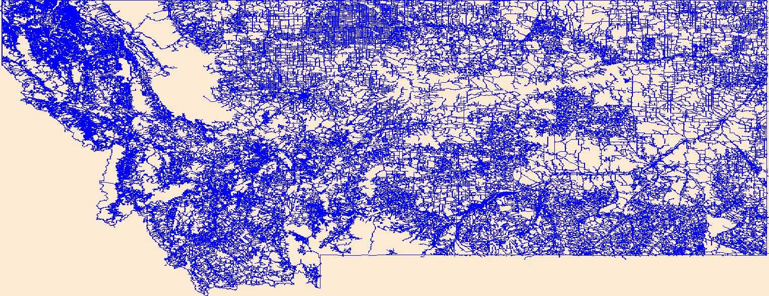
The National Hydrography Dataset (NHD) is a feature-based database that interconnects and uniquely identifies the stream segments or reaches that make up the nation's surface water drainage system. NHD data was originally developed at 1:100,000-scale and exists at that scale for the whole country. This high-resolution NHD, generally developed at 1:24,000/1:12,000 scale, adds detail to the original 1:100,000-scale NHD. (Data for Alaska, Puerto Rico and the Virgin Islands was developed at high-resolution, not 1:100,000 scale.) Local resolution NHD is being developed where partners and data exist. The NHD contains reach codes for networked features, flow direction, names, and centerline representations for areal water...
Tags: Administrative watershed units,
Administrative watershed units,
Area of Complex Channels,
Area to be submerged,
Basin, All tags...
Basin,
Bay/Inlet,
Boundaries,
Boundary,
Bridge,
Canal/Ditch,
Coastline,
Connector,
Dam/Weir,
Downloadable Data,
Drainage areas for surface water,
Drainageway,
Estuary,
Fergus,
Flow direction network,
Flume,
ForeShore,
Gaging Station,
Garfield,
Gate,
GeoPackage,
Golden Valley,
HU-8,
HU-8 Subbasin,
HU10,
HU12,
HU14,
HU16,
HU2,
HU4,
HU6,
HU8,
HU8_10040202,
HUC,
Hazard Zone,
Hydrographic,
Hydrography,
Hydrography,
Hydrography,
Hydrologic Unit Code,
Hydrologic Units,
Ice mass,
Inundation Area,
Levee,
Line,
Lock Chamber,
MT,
Marsh,
Montana,
Musselshell,
National Hydrography Dataset (NHD),
National Hydrography Dataset (NHD) Best Resolution,
National Hydrography Dataset (NHD) Best Resolution,
Nonearthen Shore,
Open Geospatial Consortium GeoPackage 1.2,
Orthoimage,
Petroleum,
Playa,
Point,
PointEvent,
Pond,
Rapids,
Rapids,
Reach,
Reach code,
Reef,
Region,
Reservoir,
Rock,
Rosebud,
Sea/Ocean,
Sink/Rise,
Sounding Datum Line,
Special Use Zone,
Special Use Zone Limit,
Spillway,
Stream,
Stream/River,
Sub-basin,
Sub-region,
Subbasin,
Submerged Stream,
Subregion,
Subwatershed,
Surface water systems,
Swamp,
Topographic,
Tunnel,
US,
Underground Conduit,
United States,
WBD,
WBD,
Wall,
Wash,
Water Intake Outflow,
Waterfall,
Watershed,
Watershed Boundaries,
Watershed Boundary Dataset,
Watershed Boundary Dataset,
Well,
Yellowstone,
artificial path,
boundaries,
dams,
drainage systems and characteristics,
inlandWaters,
lakes,
ngda,
rivers, Fewer tags
The Geographic Names Information System (GNIS) is the Federal standard for geographic nomenclature. The U.S. Geological Survey developed the GNIS for the U.S. Board on Geographic Names, a Federal inter-agency body chartered by public law to maintain uniform feature name usage throughout the Government and to promulgate standard names to the public. The GNIS is the official repository of domestic geographic names data; the official vehicle for geographic names use by all departments of the Federal Government; and the source for applying geographic names to Federal electronic and printed products of all types.
Tags: Antarctica,
Antarctica,
BGN,
Beaverhead,
Big Horn, All tags...
Blaine,
Board on Geographic Names,
Borough,
Broadwater,
Carbon,
Carter,
Cascade,
Census Area,
Chouteau,
Commonwealth,
County,
Custer,
Daniels,
Dawson,
Deer Lodge,
District,
Downloadable Data,
Fallon,
Feature class,
Feature coordinates,
Feature county,
Feature description,
Feature designation,
Feature history,
Feature indentification,
Feature name,
Feature state,
Fergus,
Flathead,
GNIS,
Gallatin,
Garfield,
Geographic Names,
Geographic Names Domestic Names,
Geographic Names Information System,
Geographic feature,
Geographic name,
Geographical feature,
Geographical name,
Glacier,
Golden Valley,
Granite,
Hill,
Jefferson,
Judith Basin,
Lake,
Lewis and Clark,
Liberty,
Lincoln,
MT,
Madison,
McCone,
Meagher,
Mineral,
Missoula,
Montana,
Municipio,
Musselshell,
National Geographic Names Information System (GNIS),
National Geographic Names Information System (GNIS),
Official feature name,
Outlying Area,
Parish,
Park,
Petroleum,
Phillips,
Place name,
Pondera,
Populated Place,
Powder River,
Powell,
Prairie,
Ravalli,
Richland,
Roosevelt,
Rosebud,
Sanders,
Sheridan,
Silver Bow,
State,
Stillwater,
Sweet Grass,
TXT (pipes),
Territories,
Territory,
Teton,
Toole,
Topographic Map,
Treasure,
U.S. Board on Geographic Names,
U.S. Geological Survey,
US,
USA,
USBGN,
USGS,
UTF-8 Pipe Delimited Text File nan,
United States,
United States,
United States,
Valley,
Variant name,
Wheatland,
Wibaux,
Yellowstone,
antarctic,
database,
economy,
environment,
feature,
gazetteer,
geographic,
geographic names,
geographical,
geography,
geospatial,
imageryBaseMapsEarthCover,
inlandWaters,
location,
map,
name,
place,
placename,
society,
structure,
topographic map,
toponymy, Fewer tags

The National Geologic Map Database (NGMDB) is a Congressionally mandated national archive of geoscience maps, reports, and stratigraphic information. The Geologic Mapping Act of 1992 and its Reauthorizations calls for the U.S. Geological Survey and the Association of American State Geologists (AASG) to cooperatively build this national archive, according to technical and scientific standards whose development is coordinated by the NGMDB. The NGMDB consists of a comprehensive set of publication citations, stratigraphic nomenclature, downloadable content in raster and vector formats, unpublished source information, and guidance on standards development. The NGMDB contains information on more than 110,000 maps and...
Tags: AASG,
Aeromagnetics,
Association of American State Geologists,
Bedrock geology,
CSS, All tags...
Coal,
Coastal and marine geology,
Core Science Systems,
Earthquakes,
Environmental hazards,
Environmental resources,
GIS,
Geochemistry,
Geochronology,
Geologic map,
Geology,
Geophysics,
Geothermal resources,
Gravity,
Hazards,
Landslides,
Metallic resources,
NCGMP,
NGDA,
NGDA Geology Theme,
NGDAID52,
NGMDB,
National Cooperative Geologic Mapping Program,
National Geologic Map Database,
National Geospatial Data Asset,
Non-metallic resources,
North America,
Oil and gas,
Paleontology,
Petroleum,
Radioactivity,
Resources,
Stratigraphic nomenclature,
Stratigraphy,
Surficial geology,
U.S.,
U.S. Geological Survey,
US,
USGS,
USGS Science Data Catalog (SDC),
USGS:366411b4-98bc-41f7-876b-778f91aff6b6,
United States,
Volcanoes,
WMS,
Water resources,
Web-mapping,
geoscientificInformation,
image service,
mapview, Fewer tags

The data set for this coverage includes arcs, polygons, and polygon labels that outline and describe the general geologic age and type of bedrock of the Arabian Peninsula and selected adjacent areas. It also includes shoreline and inland water bodies. The Arabian Peninsula is part of Region 2 for the USGS World Energy Assessment.
Categories: Data,
pre-SM502.8;
Types: Downloadable,
Map Service,
OGC WFS Layer,
OGC WMS Layer,
Shapefile;
Tags: Anah Graben, Province 2089,
Arabian Peninsula,
Arabian Shield, Province 2101,
BA,
Bahrain, All tags...
Beirut, Province 2078,
Central Oman Platform, Province 2015,
Earth Science,
East Flank Oman Sub-basin, Province 2012,
Economic geology,
Euphrates/Mardin, Province 2075,
Fahud Salt Basin, Province 2016,
Geologic map,
Geology,
Geology,
Ghaba Salt Basin, Province 2014,
Ghudun-Khasfeh Flank, Province 2010,
Greater Ghawar Uplift, Province 2021,
Gulf of Oman Basin, Province 2018,
Hail-Ga'Ara Arch, Province 2025,
Haleb, Province 2076,
Hays Structural Belt, Province 2003,
Huqf-Haushi Uplift, Province 2013,
IS,
IZ,
Interior Homocline-Central Arch, Province 2020,
Iraq,
Israel,
JO,
Jafr-Tabuk Basin, Province 2026,
Jordan,
KU,
Khleisha Uplift, Province 2074,
Kingdom of Jordan,
Kingdom of Saudi Arabia,
Kuwait,
LE,
Lebanese Republic,
Lebanon,
Levantine Basin, Province 2032,
MU,
Ma'Rib-Al Jawf/Masila Basin, Province 2004,
Masila-Jeza Basin, Province 2009,
Masirah Trough, Province 2008,
Mesopotamian Foredeep Basin, Province 2024,
Middle East,
Mirbat Precambrian Basement, Province 2102,
Mukalla Rift Basin, Province 2005,
Natural Gas,
Natural Resources,
Natural gas resources,
North Harrah Volcanics, Province 2027,
Oil,
Oil sand resources,
Oil shale resources,
Oman,
Oman Mountains, Province 2017,
Palmyra Zone, Province 2077,
Petroleum,
QA,
Qatar,
Qatar Arch, Province 2022,
Red Sea Basin, Province 2071,
Region 2,
Republic of Iraq,
Republic of Yemen,
Resource Assessment,
Rub Al Khali Basin, Province 2019,
Rutbah Uplift, Province 2028,
SA,
Saudi Arabia,
Shabwah Basin, Province 2006,
Sharmah Rift Basin, Province 2007,
Sinai Basin, Province 2033,
South Harrah Volcanics, Province 2034,
South Oman Salt Basin, Province 2011,
South Yemen,
State of Bahrain,
State of Israel,
State of Kuwait,
State of Qatar,
Sultanate of Oman,
Syria,
Syrian Arab Republic,
TC,
U.S. Geological Survey,
USGS,
USGS Science Data Catalog (SDC),
United Arab Emirates,
Wadi-Surhan Basin, Province 2029,
Widyan Basin-Interior Platform, Province 2023,
YM,
Yemen,
Yemen Volcanic Basin (North), Province 2001,
Yemen Volcanic Basin (South), Province 2002,
Zagros Fold Belt, Province 2030,
Zagros Thrust Zone, Province 2031,
arabian,
environment,
geoscientificInformation,
oilgas,
wep,
worldgeologicmaps, Fewer tags

This coverage includes arcs, polygons and polygon labels that describe Arctic portion of the U.S. Geological Survey defined geologic provinces of the World in 2000.
Categories: Data,
pre-SM502.8;
Types: Downloadable,
Map Service,
OGC WFS Layer,
OGC WMS Layer,
Shapefile;
Tags: Admiralty Arch, Province 1061,
Anabar Basin, Province 1200,
Anabar-Olenek High, Province 1202,
Anadyr Basin, Province 1300,
Anzhu Uplift, Province 1255, All tags...
Arctic,
Arctic Coastal Shelf, Province 5241,
Arctic Ocean Slope, Province 1117,
Ayon Basin, Province 1253,
Baffin Basin, Province 5207,
Baltic Shield-Norwegian Caledonides, Province 4016,
Banks Basin, Province 5233,
Barents Continental Slope, Province 4013,
Beaufort Shelf OCS, Province 5081,
Blagoveshchensk Basin, Province 1254,
Boothia Basin, Province 5230,
Canada Basin-Beaufort Slope OCS, Province 5079,
Canadian Cordillera, Province 5248,
Canadian Shield, Province 5226,
Central Alaska, Province 5002,
Central Barents Platform, Province 4012,
Central Kara High, Province 1070,
Chukchi Borderland OCS, Province 5078,
Chukchi Shelf OCS, Province 5080,
Cornwallis Foldbelt, Province 5237,
De Long High, Province 1257,
Earth Science,
East Greenland Foldbelt, Province 5201,
East Greenland Rift Basins, Province 5200,
Economic geology,
Ellesmere Foldbelt, Province 5238,
Foxe Basin, Province 5229,
Gas province,
Gas resource assessment,
Geologic province,
Geology,
Greenland Shield, Province 5202,
Grumant Uplift, Province 1064,
Hammerfest-Varanger Basin, Province 4015,
Hope Basin OCS, Province 5082,
Hudson Bay Basin, Province 5228,
Kane Basin, Province 5206,
Kempendiay Region, Province 1212,
Khatanga Saddle, Province 1201,
Kola Monocline-Finnmark Platform, Province 1051,
Koryak-Kamchatka Foldbelt, Province 1304,
Labrador-Newfoundland Shelf, Province 5215,
Laptev Shelf, Province 1218,
Lena-Vilyuy Basin, Province 1214,
Ludlov Saddle, Province 1059,
Mackenzie Delta Slope, Province 5240,
Mackenzie Delta, Province 5239,
Mackenzie Foldbelt, Province 5246,
Mezen Basin, Province 1006,
Minto Arch, Province 5235,
Moma Basin, Province 1252,
Natural Gas,
Natural Resources,
Natural gas liquids resource assessment,
Natural gas resources,
Nepa-Botuoba Arch, Province 1210,
North Barents Basin, Province 1060,
North Chukchi Basin, Province 1258,
North Greenland Foldbelt, Province 5204,
North Greenland Platform, Province 5203,
North Novaya Zemlya Basin, Province 1065,
Northern Alaska, Province 5001,
Northern Interior Basins, Province 5242,
Norton Basin OCS, Province 5086,
Novaya Zemlya Monocline, Province 1062,
Novosibirsk Basin, Province 1256,
Oil,
Oil and gas province,
Oil and gas resource assessment,
Oil province,
Oil resource assessment,
Oil sand resources,
Oil shale resources,
Parry Island Foldbelt, Province 5236,
Penzhina Basin, Province 1303,
Petroleum,
Resource Assessment,
Schmidt Basin, Province 1071,
Severnaya Zemlya High, Province 1072,
South Arctic Basin, Province 5231,
South Barents Basin, Province 1050,
South Chukchi-Hope Basin, Province 1261,
Southeast Greenland Basin, Province 5209,
St. Anna Basin, Province 1066,
Svalbard High, Province 4011,
Sverdrup Basin, Province 5234,
Taimyr-Kara High, Province 1176,
Timan High, Province 1007,
Timan-Pechora Basin, Province 1008,
Troms-Bjornoya, Province 4014,
Tunguska Basin, Province 1203,
Turukhan-Igarka Uplift, Province 1205,
Turukhan-Norilsk Folded Zone, Province 1204,
U.S. Geological Survey,
USGS,
USGS Science Data Catalog (SDC),
Uedineniya Basin, Province 1069,
Ural-Novaya Zemlya Foldbelt, Province 1017,
Ushakov High, Province 1068,
Verkhoyan-Chukotka Folded Region, Province 1250,
Vestford-Helgeland, Province 4017,
Vize High, Province 1067,
Wandel Sea Basin, Province 5205,
West Greenland Basin, Province 5208,
West Siberian Basin, Province 1174,
Wollaston Basin, Province 5232,
Wrangel Basin, Province 1259,
Wrangel-Herald Uplift, Province 1260,
Yenisey-Khatanga Basin, Province 1175,
Yukon Basin, Province 5247,
Zyryanka Basin, Province 1251,
arctic,
environment,
geoscientificInformation,
oilgas,
wep,
worldgeologicmaps, Fewer tags
|
|

