Filters: partyWithName: U.S. Geological Survey (X) > partyWithName: Wyoming-Montana Water Science Center (X)
61 results (345ms)|
Filters
Date Range
Types Contacts
Categories Tag Types Tag Schemes |

These data were released prior to the October 1, 2016 effective date for the USGS’s policy dictating the review, approval, and release of scientific data as referenced in USGS Survey Manual Chapter 502.8 Fundamental Science Practices: Review and Approval of Scientific Data for Release. These data represent the thickness, in feet, of the Upper Hell Creek hydrogeologic unit in the Powder River basin. The data are presented as ASCII text files that can be converted to continuous raster format.

These data were released prior to the October 1, 2016 effective date for the USGS’s policy dictating the review, approval, and release of scientific data as referenced in USGS Survey Manual Chapter 502.8 Fundamental Science Practices: Review and Approval of Scientific Data for Release. These data represent the thickness, in feet, of the glacial aquifer system in the Williston structural basin. The data are presented as ASCII text files that can be converted to continuous raster format.

These data were released prior to the October 1, 2016 effective date for the USGS’s policy dictating the review, approval, and release of scientific data as referenced in USGS Survey Manual Chapter 502.8 Fundamental Science Practices: Review and Approval of Scientific Data for Release. These data represent the extent of the Fox Hills aquifer in the Powder River and Williston structural basins.

These data were released prior to the October 1, 2016 effective date for the USGS’s policy dictating the review, approval, and release of scientific data as referenced in USGS Survey Manual Chapter 502.8 Fundamental Science Practices: Review and Approval of Scientific Data for Release. This feature class represents the southern extent of glacial deposits in the Williston Structural basin.

These data were released prior to the October 1, 2016 effective date for the USGS’s policy dictating the review, approval, and release of scientific data as referenced in USGS Survey Manual Chapter 502.8 Fundamental Science Practices: Review and Approval of Scientific Data for Release. These data represent the altitude, in feet above North American Vertical Datum of 1988 (NAVD88), of the lower Fort Union aquifer in the Williston structural basin. The data are presented as ASCII text files that can be converted to continuous raster format.

These data were released prior to the October 1, 2016 effective date for the USGS’s policy dictating the review, approval, and release of scientific data as referenced in USGS Survey Manual Chapter 502.8 Fundamental Science Practices: Review and Approval of Scientific Data for Release. These data represent the extent of the upper Fort Union aquifer in the Powder River and Williston structural basins.

These data were released prior to the October 1, 2016 effective date for the USGS’s policy dictating the review, approval, and release of scientific data as referenced in USGS Survey Manual Chapter 502.8 Fundamental Science Practices: Review and Approval of Scientific Data for Release. These data represent the extent of the Lower Hell Creek aquifer in the Powder River and Williston structural basins.

These data were released prior to the October 1, 2016 effective date for the USGS’s policy dictating the review, approval, and release of scientific data as referenced in USGS Survey Manual Chapter 502.8 Fundamental Science Practices: Review and Approval of Scientific Data for Release. These data represent the thickness, in feet, of the upper Fort Union aquifer in the Williston structural basin. The data are presented as ASCII text files that can be converted to continuous raster format.

These data were released prior to the October 1, 2016 effective date for the USGS’s policy dictating the review, approval, and release of scientific data as referenced in USGS Survey Manual Chapter 502.8 Fundamental Science Practices: Review and Approval of Scientific Data for Release. These data represent the thickness, in feet, of the Lower Hell Creek aquifer in the Williston structural basin. The data are presented as ASCII text files that can be converted to continuous raster format.

These data were released prior to the October 1, 2016 effective date for the USGS’s policy dictating the review, approval, and release of scientific data as referenced in USGS Survey Manual Chapter 502.8 Fundamental Science Practices: Review and Approval of Scientific Data for Release. These data represent the altitude, in feet above North American Vertical Datum of 1988 (NAVD88), of the basal confining unit in the Powder River basin. The data are presented as ASCII text files that can be converted to continuous raster format.
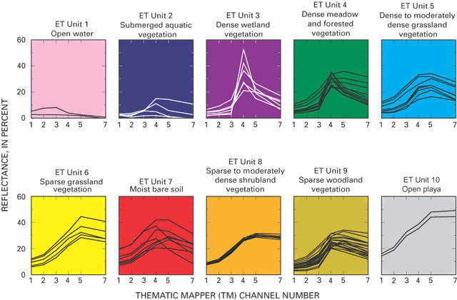
These data were released prior to the October 1, 2016 effective date for the USGS’s policy dictating the review, approval, and release of scientific data as referenced in USGS Survey Manual Chapter 502.8 Fundamental Science Practices: Review and Approval of Scientific Data for Release. The raster-based classification of evapotranspiration (ET) units is for nine major discharge areas in the Death Valley regional flow system. The ET units delineate general areas of similar vegetation and soil-moisture conditions. Classifications were derived from Landsat Thematic Mapper imagery data acquired June 13, 1992; Sept. 1, 1992; and June 21, 1989.

These data were released prior to the October 1, 2016 effective date for the USGS’s policy dictating the review, approval, and release of scientific data as referenced in USGS Survey Manual Chapter 502.8 Fundamental Science Practices: Review and Approval of Scientific Data for Release. These data represent the extent of the middle Fort Union hydrogeologic unit in the Powder River and Williston structural basins.
The USGS Wyoming-Montana Water Science Center (WY–MT WSC) recently completed a report (Sando and McCarthy, 2018) documenting methods for peak-flow frequency analysis following implementation of the Bulletin 17C guidelines. The methods are used to provide estimates of peak-flow quantiles for 50-, 42.9-, 20-, 10-, 4-, 2-, 1-, 0.5-, and 0.2-percent annual exceedance probabilities (AEPs) for selected streamgages operated by the WY–MT WSC. In association with the report, this data release presents peak-flow frequency analyses for 14 selected streamgages in the Beaverhead River and Clark Fork Basins that were based on methods described by Sando and McCarthy (2018). The results are presented in three child items: a child...
Categories: Data Release - Revised;
Types: Map Service,
OGC WFS Layer,
OGC WMS Layer,
OGC WMS Service;
Tags: Montana,
USGS Science Data Catalog (SDC),
Water Resources,
annual exceedance probability,
hydrology,
These data were released prior to the October 1, 2016 effective date for the USGS’s policy dictating the review, approval, and release of scientific data as referenced in USGS Survey Manual Chapter 502.8 Fundamental Science Practices: Review and Approval of Scientific Data for Release. As part of the U.S. Geological Survey's National Water-Quality Assessment Program, an investigation of the Yellowstone River Basin study unit is being conducted to document status and trends in surface- and ground-water quality. Surface-water samples are collected from streams (or lakes) at specific sampling stations. Water-quality characteristics at each station are influenced by the natural and cultural characteristics of the drainage...

These data were released prior to the October 1, 2016 effective date for the USGS’s policy dictating the review, approval, and release of scientific data as referenced in USGS Survey Manual Chapter 502.8 Fundamental Science Practices: Review and Approval of Scientific Data for Release. These data represent the extent of the lower Fort Union aquifer in the Powder River and Williston structural basins.

These data were released prior to the October 1, 2016 effective date for the USGS’s policy dictating the review, approval, and release of scientific data as referenced in USGS Survey Manual Chapter 502.8 Fundamental Science Practices: Review and Approval of Scientific Data for Release. These data represent the extent of the Upper Hell Creek hydrogeologic unit in the Powder River and Williston structural basins.
The USGS Wyoming-Montana Water Science Center (WY–MT WSC) recently completed a report (Sando and McCarthy, 2018) documenting methods for peak-flow frequency analysis following implementation of the Bulletin 17C guidelines. The methods are used to provide estimates of peak-flow quantiles for 50-, 42.9-, 20-, 10-, 4-, 2-, 1-, 0.5-, and 0.2-percent annual exceedance probabilities (AEPs) for selected streamgages operated by the WY–MT WSC. In association with the report, this data release presents peak-flow frequency analyses for 14 selected streamgages in the Ruby, Jefferson, and Madison River Basins that were based on methods described by Sando and McCarthy (2018). The results are presented in three child items: a...
Categories: Data;
Tags: Montana,
USGS Science Data Catalog (SDC),
Water Resources,
annual exceedance probability,
hydrology,
Canadian discrete water quality data and daily streamflow records were evaluated using the Weighted Regression on Time, Discharge, and Seasons (WRTDS) model implemented with the EGRET R package (Hirsch et al. 2010, Hirsch and De Cicco 2015). Models were used to estimate loads of solutes and evaluate trends for three constituents of interest (selenium, nitrate, and sulfate). Six models were generated; one model for each of the three constituents of interest, in each of the two major tributaries to Lake Koocanusa: the Kootenay River at Fenwick (BC08NG0009), and the Elk River above Highway 93 Near Elko (BC08NK0003). Data were obtained by downloading data from the British Columbia Water Tool (https://kwt.bcwatertool.ca/surface-water-quality,...
Types: Map Service,
OGC WFS Layer,
OGC WMS Layer,
OGC WMS Service;
Tags: British Columbia,
Canada,
Coal Mining,
Elk River,
Koocanusa Reservoir,
Water, bed sediment, and biota were sampled in selected streams from Butte to near Missoula, Montana, as part of a monitoring program in the upper Clark Fork Basin of western Montana. The sampling program was led by the U.S. Geological Survey (USGS), in cooperation with the U.S. Environmental Protection Agency.
Categories: Data;
Types: Map Service,
OGC WFS Layer,
OGC WMS Layer,
OGC WMS Service;
Tags: Aquatic Biology,
Clark Fork Basin,
Hydrology,
Montana,
USGS Science Data Catalog (SDC),
We used a before-and-after study design to examine effects of changes in cattle grazing practices on channel stability in Muddy Creek, an arroyo in the Colorado River headwaters. The changes in grazing practices were abrupt and focused on keeping cattle out of the riparian zone and increasing herd movement. We digitized 620 meander loop cutoff geometries within the alluvial valley bottom of Muddy Creek. Poisson regression modeling of meander loop cutoff rate indicated that the change in grazing practices caused a decline in meander loop cutoff rate that was on the scale of an order of magnitude and independent of other hydroclimatic and human-caused factors. The polyline data released here was used in our analysis...
Types: Map Service,
OGC WFS Layer,
OGC WMS Layer,
OGC WMS Service;
Tags: Colorado River,
Little Snake River,
Muddy Creek,
Wyoming,
water
|

|
