Filters
Date Range
Types
Contacts
Categories
Tag Types
Tag Schemes
|
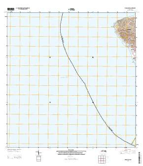
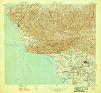
Layered GeoPDF Quadrangle Map. Layers of geospatial data include orthoimagery, roads, grids, geographic names, elevation contours, hydrography, and other selected map features.
Tags: 7.5 x 7.5 minute,
Downloadable Data,
EarthCover,
GeoPDF,
Imagery and Base Maps, All tags...
Map,
Mayagüez,
Public Land Survey System,
Puerto Rico,
Rincón,
Rincón OE W, PR,
U.S. National Grid,
US,
US Topo,
US Topo Historical,
United States,
boundary,
contour,
geographic names,
hydrography,
imageryBaseMapsEarthCover,
orthoimage,
structures,
topographic,
transportation,
woodland, Fewer tags

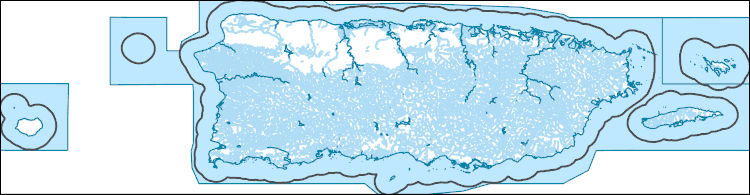
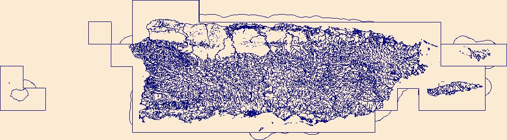
This data represents the map extent for current and historical USGS topographic maps for the United States and Territories, including 1 X 2 Degree, 1 X 1 Degree, 30 X 60 Minute, 15 X 15 Minute, 7.5 X 7.5 Minute, and 3.75 X 3.75 Minute. The grid was generated using ESRI ArcInfo GIS software.
Tags: Adjuntas,
Aguada,
Aguadilla,
Aguas Buenas,
Aibonito, All tags...
Arecibo,
Arroyo,
Añasco,
Barceloneta,
Barranquitas,
Bayamón,
Boundaries,
Cabo Rojo,
Caguas,
Camuy,
Canóvanas,
Carolina,
Cataño,
Cayey,
Ceiba,
Ciales,
Cidra,
Coamo,
Comerío,
Corozal,
Culebra,
Dorado,
Downloadable Data,
Esri File GeoDatabase 10,
Fajardo,
FileGDB,
Florida,
Guayama,
Guayanilla,
Guaynabo,
Gurabo,
Guánica,
Hatillo,
Hormigueros,
Humacao,
Isabela,
Jayuya,
Juana Díaz,
Juncos,
Lajas,
Lares,
Las Marías,
Las Piedras,
Loíza,
Luquillo,
Manatí,
Map Indices,
Map Indices,
Map Indices,
Maricao,
Maunabo,
Mayagüez,
Moca,
Morovis,
Naguabo,
Naranjito,
Orocovis,
PR,
Patillas,
Peñuelas,
Ponce,
Puerto Rico,
Quebradillas,
Rincón,
Río Grande,
Sabana Grande,
Salinas,
San Germán,
San Juan,
San Lorenzo,
San Sebastián,
Santa Isabel,
State,
State,
Toa Alta,
Toa Baja,
Trujillo Alto,
US,
United States,
United States of America,
Utuado,
Vega Alta,
Vega Baja,
Vieques,
Villalba,
Yabucoa,
Yauco,
cells,
map indices,
polygon grid, Fewer tags

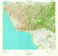
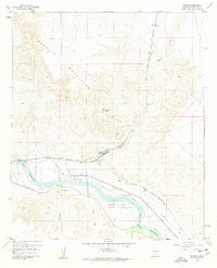
USGS Historical Quadrangle in GeoPDF.
Tags: 7.5 x 7.5 minute,
Downloadable Data,
GeoPDF,
GeoTIFF,
Historical Topographic Maps, All tags...
Historical Topographic Maps 7.5 x 7.5 Minute Map Series,
Map,
PR,
Rincon,
imageryBaseMapsEarthCover, Fewer tags
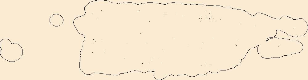
The National Hydrography Dataset (NHD) is a feature-based database that interconnects and uniquely identifies the stream segments or reaches that make up the nation's surface water drainage system. NHD data was originally developed at 1:100,000-scale and exists at that scale for the whole country. This high-resolution NHD, generally developed at 1:24,000/1:12,000 scale, adds detail to the original 1:100,000-scale NHD. (Data for Alaska, Puerto Rico and the Virgin Islands was developed at high-resolution, not 1:100,000 scale.) Local resolution NHD is being developed where partners and data exist. The NHD contains reach codes for networked features, flow direction, names, and centerline representations for areal water...
Tags: Adjuntas,
Administrative watershed units,
Administrative watershed units,
Aguada,
Aguadilla, All tags...
Aguas Buenas,
Aibonito,
Area of Complex Channels,
Area to be submerged,
Arecibo,
Arroyo,
Añasco,
Barceloneta,
Barranquitas,
Basin,
Basin,
Bay/Inlet,
Bayamón,
Boundaries,
Boundary,
Bridge,
Cabo Rojo,
Caguas,
Camuy,
Canal/Ditch,
Canóvanas,
Carolina,
Cataño,
Cayey,
Ceiba,
Ciales,
Cidra,
Coamo,
Coastline,
Comerío,
Connector,
Corozal,
Culebra,
Dam/Weir,
Dorado,
Downloadable Data,
Drainage areas for surface water,
Drainageway,
Esri Shapefile nan,
Estuary,
Fajardo,
Florida,
Flow direction network,
Flume,
ForeShore,
Gaging Station,
Gate,
Guayama,
Guayanilla,
Guaynabo,
Gurabo,
Guánica,
HU-4,
HU-4 Subregion,
HU10,
HU12,
HU14,
HU16,
HU2,
HU4,
HU4_2101,
HU6,
HU8,
HUC,
Hatillo,
Hazard Zone,
Hormigueros,
Humacao,
Hydrographic,
Hydrography,
Hydrography,
Hydrography,
Hydrologic Unit Code,
Hydrologic Units,
Ice mass,
Inundation Area,
Isabela,
Jayuya,
Juana Díaz,
Juncos,
Lajas,
Lares,
Las Marías,
Las Piedras,
Levee,
Line,
Lock Chamber,
Loíza,
Luquillo,
Manatí,
Maricao,
Marsh,
Maunabo,
Mayagüez,
Moca,
Morovis,
Naguabo,
Naranjito,
National Hydrography Dataset (NHD),
National Hydrography Dataset (NHD) Best Resolution,
National Hydrography Dataset (NHD) Best Resolution,
Nonearthen Shore,
Orocovis,
Orthoimage,
PR,
Patillas,
Peñuelas,
Playa,
Point,
PointEvent,
Ponce,
Pond,
Puerto Rico,
Quebradillas,
Rapids,
Rapids,
Reach,
Reach code,
Reef,
Region,
Reservoir,
Rincón,
Rock,
Río Grande,
Sabana Grande,
Salinas,
San Germán,
San Juan,
San Lorenzo,
San Sebastián,
Santa Isabel,
Sea/Ocean,
Shapefile,
Sink/Rise,
Sounding Datum Line,
Special Use Zone,
Special Use Zone Limit,
Spillway,
Stream,
Stream/River,
Sub-basin,
Sub-region,
Subbasin,
Submerged Stream,
Subregion,
Subwatershed,
Surface water systems,
Swamp,
Toa Alta,
Toa Baja,
Topographic,
Trujillo Alto,
Tunnel,
US,
Underground Conduit,
United States,
Utuado,
Vega Alta,
Vega Baja,
Vieques,
Villalba,
WBD,
WBD,
Wall,
Wash,
Water Intake Outflow,
Waterfall,
Watershed,
Watershed Boundaries,
Watershed Boundary Dataset,
Watershed Boundary Dataset,
Well,
Yabucoa,
Yauco,
artificial path,
boundaries,
dams,
drainage systems and characteristics,
inlandWaters,
lakes,
ngda,
rivers, Fewer tags
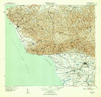
USGS Historical Quadrangle in GeoPDF.
Tags: 7.5 x 7.5 minute,
Downloadable Data,
GeoPDF,
GeoTIFF,
Historical Topographic Maps, All tags...
Historical Topographic Maps 7.5 x 7.5 Minute Map Series,
Map,
PR,
Rincon,
imageryBaseMapsEarthCover, Fewer tags
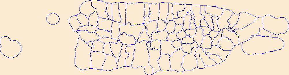
Geospatial data is comprised of government boundaries.
Tags: Adjuntas,
Aguada,
Aguadilla,
Aguas Buenas,
Aibonito, All tags...
Arecibo,
Arroyo,
Añasco,
Barceloneta,
Barranquitas,
Bayamón,
Boundaries,
Cabo Rojo,
Caguas,
Camuy,
Canóvanas,
Carolina,
Cataño,
Cayey,
Ceiba,
Ciales,
Cidra,
Coamo,
Comerío,
Corozal,
County or Equivalent,
Culebra,
Dorado,
Downloadable Data,
Fajardo,
Florida,
GeoPackage,
Guayama,
Guayanilla,
Guaynabo,
Gurabo,
Guánica,
Hatillo,
Hormigueros,
Humacao,
Incorporated Place,
Isabela,
Jayuya,
Juana Díaz,
Juncos,
Jurisdictional,
Lajas,
Lares,
Las Marías,
Las Piedras,
Loíza,
Luquillo,
Manatí,
Maricao,
Maunabo,
Mayagüez,
Minor Civil Division,
Moca,
Morovis,
Naguabo,
Naranjito,
National Boundary Dataset (NBD),
National Boundary Dataset (NBD),
Native American Area,
Open Geospatial Consortium GeoPackage 1.2,
Orocovis,
PLSS First Division,
PLSS Special Survey,
PLSS Township,
PR,
Patillas,
Peñuelas,
Ponce,
Public Land Survey System,
Puerto Rico,
Quebradillas,
Reserve,
Rincón,
Río Grande,
Sabana Grande,
Salinas,
San Germán,
San Juan,
San Lorenzo,
San Sebastián,
Santa Isabel,
State,
State,
State or Territory,
Toa Alta,
Toa Baja,
Trujillo Alto,
U.S. National Grid,
US,
Unincorporated Place,
United States,
Utuado,
Vega Alta,
Vega Baja,
Vieques,
Villalba,
Yabucoa,
Yauco,
boundaries,
boundary,
cadastral surveys,
geographic names,
land ownership,
land use maps,
legal land descriptions,
political and administrative boundaries,
zoning maps, Fewer tags
USGS Historical Quadrangle in GeoPDF.
Tags: 7.5 x 7.5 minute,
Downloadable Data,
GA,
GeoPDF,
GeoTIFF, All tags...
Historical Topographic Maps,
Historical Topographic Maps 7.5 x 7.5 Minute Map Series,
Map,
Rincon,
imageryBaseMapsEarthCover, Fewer tags

USGS Historical Quadrangle in GeoPDF.
Tags: 7.5 x 7.5 minute,
Downloadable Data,
GeoPDF,
GeoTIFF,
Historical Topographic Maps, All tags...
Historical Topographic Maps 7.5 x 7.5 Minute Map Series,
Map,
PR,
Rincon,
imageryBaseMapsEarthCover, Fewer tags
Layers of geospatial data include roads, airports, trails, and railroads.
Tags: Adjuntas,
Aguada,
Aguadilla,
Aguas Buenas,
Aibonito, All tags...
Airport Complex,
Airport Point,
Airport Runway,
Airports,
Airstrips,
Arecibo,
Arroyo,
Añasco,
Barceloneta,
Barranquitas,
Bayamón,
Cabo Rojo,
Caguas,
Camuy,
Canóvanas,
Carolina,
Cataño,
Cayey,
Ceiba,
Ciales,
Cidra,
Coamo,
Comerío,
Corozal,
Culebra,
Dorado,
Downloadable Data,
Fajardo,
Florida,
GeoPackage,
Geographic names,
Guayama,
Guayanilla,
Guaynabo,
Gurabo,
Guánica,
Hatillo,
Hormigueros,
Humacao,
Isabela,
Jayuya,
Juana Díaz,
Juncos,
Lajas,
Lares,
Las Marías,
Las Piedras,
Loíza,
Luquillo,
Manatí,
Maricao,
Maunabo,
Mayagüez,
Moca,
Morovis,
Naguabo,
Naranjito,
National Transportation Dataset (NTD),
National Transportation Dataset (NTD),
Open Geospatial Consortium GeoPackage 1.2,
Orocovis,
PR,
Patillas,
Peñuelas,
Ponce,
Puerto Rico,
Quebradillas,
Railways,
Rincón,
Roads,
Río Grande,
Sabana Grande,
Salinas,
San Germán,
San Juan,
San Lorenzo,
San Sebastián,
Santa Isabel,
State,
State,
Toa Alta,
Toa Baja,
Trail,
Trails,
Transportation,
Transportation,
Trujillo Alto,
US,
United States,
Utuado,
Vega Alta,
Vega Baja,
Vieques,
Villalba,
Waterway,
Yabucoa,
Yauco,
transportation, Fewer tags
Geospatial data includes structures and other selected map features.
Tags: Adjuntas,
Aguada,
Aguadilla,
Aguas Buenas,
Aibonito, All tags...
Arecibo,
Arroyo,
Añasco,
Barceloneta,
Barranquitas,
Bayamón,
Cabo Rojo,
Caguas,
Campground,
Camuy,
Canóvanas,
Carolina,
Cataño,
Cayey,
Ceiba,
Ciales,
Cidra,
Coamo,
College / University,
Comerío,
Corozal,
Courthouse,
Culebra,
Dorado,
Downloadable Data,
Esri File GeoDatabase 10,
Fajardo,
FileGDB,
Fire Station/ EMS Station,
Florida,
Guayama,
Guayanilla,
Guaynabo,
Gurabo,
Guánica,
Hatillo,
Hormigueros,
Hospital/Medical Center,
Humacao,
Information Center,
Isabela,
Jayuya,
Juana Díaz,
Juncos,
Lajas,
Lares,
Las Marías,
Las Piedras,
Law Enforcement,
Loíza,
Luquillo,
Manatí,
Maricao,
Maunabo,
Mayagüez,
Moca,
Morovis,
Naguabo,
Naranjito,
National Structures Dataset (NSD),
National Structures Dataset (NSD),
Orocovis,
PR,
Patillas,
Peñuelas,
Ponce,
Post Office,
Prison/ Correctional Facility,
Puerto Rico,
Quebradillas,
Rincón,
Río Grande,
Sabana Grande,
Salinas,
San Germán,
San Juan,
San Lorenzo,
San Sebastián,
Santa Isabel,
School,
School:Elementary,
School:High School,
School:Middle School,
State,
State,
State Capitol,
Structures,
Technical School,
Toa Alta,
Toa Baja,
Town Hall,
Trade School,
Trailhead,
Trujillo Alto,
US,
United States,
Utuado,
Vega Alta,
Vega Baja,
Vieques,
Villalba,
Visitor Center,
Yabucoa,
Yauco,
structure, Fewer tags
The National Hydrography Dataset (NHD) is a feature-based database that interconnects and uniquely identifies the stream segments or reaches that make up the nation's surface water drainage system. NHD data was originally developed at 1:100,000-scale and exists at that scale for the whole country. This high-resolution NHD, generally developed at 1:24,000/1:12,000 scale, adds detail to the original 1:100,000-scale NHD. (Data for Alaska, Puerto Rico and the Virgin Islands was developed at high-resolution, not 1:100,000 scale.) Local resolution NHD is being developed where partners and data exist. The NHD contains reach codes for networked features, flow direction, names, and centerline representations for areal water...
Tags: Adjuntas,
Administrative watershed units,
Administrative watershed units,
Aguada,
Aguadilla, All tags...
Area of Complex Channels,
Area to be submerged,
Añasco,
Basin,
Basin,
Bay/Inlet,
Boundaries,
Boundary,
Bridge,
Cabo Rojo,
Canal/Ditch,
Coastline,
Connector,
Dam/Weir,
Downloadable Data,
Drainage areas for surface water,
Drainageway,
Esri File GeoDatabase 10,
Estuary,
FileGDB,
Flow direction network,
Flume,
ForeShore,
Gaging Station,
Gate,
Guayanilla,
HU-8,
HU-8 Subbasin,
HU10,
HU12,
HU14,
HU16,
HU2,
HU4,
HU6,
HU8,
HU8_21010003,
HUC,
Hazard Zone,
Hormigueros,
Hydrographic,
Hydrography,
Hydrography,
Hydrography,
Hydrologic Unit Code,
Hydrologic Units,
Ice mass,
Inundation Area,
Isabela,
Lajas,
Lares,
Las Marías,
Levee,
Line,
Lock Chamber,
Maricao,
Marsh,
Mayagüez,
Moca,
National Hydrography Dataset (NHD),
National Hydrography Dataset (NHD) Best Resolution,
National Hydrography Dataset (NHD) Best Resolution,
Nonearthen Shore,
Orthoimage,
PR,
Playa,
Point,
PointEvent,
Pond,
Puerto Rico,
Rapids,
Rapids,
Reach,
Reach code,
Reef,
Region,
Reservoir,
Rincón,
Rock,
Sabana Grande,
San Germán,
San Sebastián,
Sea/Ocean,
Sink/Rise,
Sounding Datum Line,
Special Use Zone,
Special Use Zone Limit,
Spillway,
Stream,
Stream/River,
Sub-basin,
Sub-region,
Subbasin,
Submerged Stream,
Subregion,
Subwatershed,
Surface water systems,
Swamp,
Topographic,
Tunnel,
US,
Underground Conduit,
United States,
Utuado,
WBD,
WBD,
Wall,
Wash,
Water Intake Outflow,
Waterfall,
Watershed,
Watershed Boundaries,
Watershed Boundary Dataset,
Watershed Boundary Dataset,
Well,
Yauco,
artificial path,
boundaries,
dams,
drainage systems and characteristics,
inlandWaters,
lakes,
ngda,
rivers, Fewer tags

This section of the data release includes core images in the format of photos (JPG) that have been compressed into a zipped file (2018LakePowellCoring_CorePhotos.zip). It is Part 4 (of four) in this data release and contains images of the cleaned archival half from split cores as they appeared immediately after splitting (late March and early April 2019). Each photo includes a ruler (in centimeters) and X-Rite ColorChecker Classic color correction card that may be used for corrections. Drillhole information, such as location and total recovery, are outlined in “Part 1 – Drillhole information from the 2018 coring project in Lake Powell, Utah” (2018LakePowellCoring_DrillholeInfo.csv) of this data release. Each drillhole...
Types: Map Service,
OGC WFS Layer,
OGC WMS Layer,
OGC WMS Service;
Tags: Animas River,
Antelope Canyon,
Bears Ears National Monument,
Bullfrog,
Bullfrog Bay, All tags...
Canyonlands National Park,
Capitol Reef National Park,
Castle Butte,
Cataract Canyon,
Cha Bay,
Cha Canyon,
Coconino County,
Colorado River,
Dangling Rope,
Deep Canyon,
Dirty Devil River,
Escalante River,
Farley Canyon,
Fourmile Canyon,
Friendship Bay,
Garfield County,
Glen Canyon Dam,
Glen Canyon National Recreation Area,
Gold King Mine,
Good Hope Bay,
Grand Staircase-Escalante National Monument,
Great Bend,
Gunsight bay,
Halls Bay,
Halls Crossing,
Hite,
Hole in the Rock,
Kane County,
Lake Powell,
Last Chance Bay,
Mexican Hat,
Monument Valley,
Narrow Canyon,
Navajo Canyon,
Neshkahi Wash,
North Wash,
Padre Bay,
Page,
Piuite Canyon,
Piute Farms Wash,
Piute Mesa,
Piute Wash,
Rainbow Bridge National Monument,
Reflection Canyon,
Rincon,
Rock Creek Bay,
San Juan County,
San Juan River,
Silverton,
State of Arizona,
State of Utah,
The Horn,
Trachyte Canyon,
Twomile Canyon,
United States of America,
Wahweap,
Wahweap Bay,
Warm Creek Bay,
White Canyon,
Wilson Mesa,
Zahn Bay,
bathymetry,
bedforms,
bulk density,
clay deposits,
contaminant transport,
contamination and pollution,
core analysis,
dissolved metals,
drilling and coring,
field inventory and monitoring,
geomorphology,
gravel deposits,
groundwater and surface-water interaction,
hazards,
human environmental safety,
hydrogeology,
hydrologic processes,
hydrology,
image analysis,
industrial pollution,
lakebed characteristics,
lidar,
limnology,
magnetic susceptibility analysis,
mine drainage,
mine waste,
national centers,
partnerships,
photography,
piston coring,
recreation,
remediation,
resistivity,
rotary coring,
sample repositories,
sand deposits,
sedimentation,
sedimentology,
sediment transport,
soil horizons,
spectrophotometry,
stratigraphic sections,
stratigraphic thickness,
stratigraphy,
stream-gage measurement,
streamflow,
surface-water level,
surface water (non-marine),
surface water quality,
suspended material,
toxic trace element contamination,
turbidity,
unconsolidated deposits,
water circulation,
water resources,
water supply and demand, Fewer tags
USGS Historical Quadrangle in GeoPDF.
Tags: 7.5 x 7.5 minute,
Downloadable Data,
GeoPDF,
GeoTIFF,
Historical Topographic Maps, All tags...
Historical Topographic Maps 7.5 x 7.5 Minute Map Series,
Map,
PR,
Rincon,
imageryBaseMapsEarthCover, Fewer tags
USGS Historical Quadrangle in GeoPDF.
Tags: 7.5 x 7.5 minute,
Downloadable Data,
GeoPDF,
GeoTIFF,
Historical Topographic Maps, All tags...
Historical Topographic Maps 7.5 x 7.5 Minute Map Series,
Map,
NM,
Rincon,
imageryBaseMapsEarthCover, Fewer tags

USGS Historical Quadrangle in GeoPDF.
Tags: 7.5 x 7.5 minute,
Downloadable Data,
GeoPDF,
GeoTIFF,
Historical Topographic Maps, All tags...
Historical Topographic Maps 7.5 x 7.5 Minute Map Series,
Map,
Puerto Rico,
Rincon,
imageryBaseMapsEarthCover, Fewer tags
The National Hydrography Dataset (NHD) is a feature-based database that interconnects and uniquely identifies the stream segments or reaches that make up the nation's surface water drainage system. NHD data was originally developed at 1:100,000-scale and exists at that scale for the whole country. This high-resolution NHD, generally developed at 1:24,000/1:12,000 scale, adds detail to the original 1:100,000-scale NHD. (Data for Alaska, Puerto Rico and the Virgin Islands was developed at high-resolution, not 1:100,000 scale.) Local resolution NHD is being developed where partners and data exist. The NHD contains reach codes for networked features, flow direction, names, and centerline representations for areal water...
Tags: Adjuntas,
Administrative watershed units,
Administrative watershed units,
Aguada,
Aguadilla, All tags...
Aguas Buenas,
Aibonito,
Area of Complex Channels,
Area to be submerged,
Arecibo,
Arroyo,
Añasco,
Barceloneta,
Barranquitas,
Basin,
Basin,
Bay/Inlet,
Bayamón,
Boundaries,
Boundary,
Bridge,
Cabo Rojo,
Caguas,
Camuy,
Canal/Ditch,
Canóvanas,
Carolina,
Cataño,
Cayey,
Ceiba,
Ciales,
Cidra,
Coamo,
Coastline,
Comerío,
Connector,
Corozal,
Culebra,
Dam/Weir,
Dorado,
Downloadable Data,
Drainage areas for surface water,
Drainageway,
Esri Shapefile nan,
Estuary,
Fajardo,
Florida,
Flow direction network,
Flume,
ForeShore,
Gaging Station,
Gate,
Guayama,
Guayanilla,
Guaynabo,
Gurabo,
Guánica,
HU10,
HU12,
HU14,
HU16,
HU2,
HU4,
HU6,
HU8,
HUC,
Hatillo,
Hazard Zone,
Hormigueros,
Humacao,
Hydrographic,
Hydrography,
Hydrography,
Hydrography,
Hydrologic Unit Code,
Hydrologic Units,
Ice mass,
Inundation Area,
Isabela,
Jayuya,
Juana Díaz,
Juncos,
Lajas,
Lares,
Las Marías,
Las Piedras,
Levee,
Line,
Lock Chamber,
Loíza,
Luquillo,
Manatí,
Maricao,
Marsh,
Maunabo,
Mayagüez,
Moca,
Morovis,
Naguabo,
Naranjito,
National Hydrography Dataset (NHD),
National Hydrography Dataset (NHD) Best Resolution,
National Hydrography Dataset (NHD) Best Resolution,
Nonearthen Shore,
Orocovis,
Orthoimage,
PR,
Patillas,
Peñuelas,
Playa,
Point,
PointEvent,
Ponce,
Pond,
Puerto Rico,
Quebradillas,
Rapids,
Rapids,
Reach,
Reach code,
Reef,
Region,
Reservoir,
Rincón,
Rock,
Río Grande,
Sabana Grande,
Salinas,
San Germán,
San Juan,
San Lorenzo,
San Sebastián,
Santa Isabel,
Sea/Ocean,
Shapefile,
Sink/Rise,
Sounding Datum Line,
Special Use Zone,
Special Use Zone Limit,
Spillway,
State,
State,
State_Puerto Rico,
Stream,
Stream/River,
Sub-basin,
Sub-region,
Subbasin,
Submerged Stream,
Subregion,
Subwatershed,
Surface water systems,
Swamp,
Toa Alta,
Toa Baja,
Topographic,
Trujillo Alto,
Tunnel,
US,
Underground Conduit,
United States,
Utuado,
Vega Alta,
Vega Baja,
Vieques,
Villalba,
WBD,
WBD,
Wall,
Wash,
Water Intake Outflow,
Waterfall,
Watershed,
Watershed Boundaries,
Watershed Boundary Dataset,
Watershed Boundary Dataset,
Well,
Yabucoa,
Yauco,
artificial path,
boundaries,
dams,
drainage systems and characteristics,
inlandWaters,
lakes,
ngda,
rivers, Fewer tags

The National Hydrography Dataset (NHD) is a feature-based database that interconnects and uniquely identifies the stream segments or reaches that make up the nation's surface water drainage system. NHD data was originally developed at 1:100,000-scale and exists at that scale for the whole country. This high-resolution NHD, generally developed at 1:24,000/1:12,000 scale, adds detail to the original 1:100,000-scale NHD. (Data for Alaska, Puerto Rico and the Virgin Islands was developed at high-resolution, not 1:100,000 scale.) Local resolution NHD is being developed where partners and data exist. The NHD contains reach codes for networked features, flow direction, names, and centerline representations for areal water...
Tags: Adjuntas,
Administrative watershed units,
Administrative watershed units,
Aguada,
Aguadilla, All tags...
Aguas Buenas,
Aibonito,
Area of Complex Channels,
Area to be submerged,
Arecibo,
Arroyo,
Añasco,
Barceloneta,
Barranquitas,
Basin,
Basin,
Bay/Inlet,
Bayamón,
Boundaries,
Boundary,
Bridge,
Cabo Rojo,
Caguas,
Camuy,
Canal/Ditch,
Canóvanas,
Carolina,
Cataño,
Cayey,
Ceiba,
Ciales,
Cidra,
Coamo,
Coastline,
Comerío,
Connector,
Corozal,
Culebra,
Dam/Weir,
Dorado,
Downloadable Data,
Drainage areas for surface water,
Drainageway,
Estuary,
Fajardo,
Florida,
Flow direction network,
Flume,
ForeShore,
Gaging Station,
Gate,
GeoPackage,
Guayama,
Guayanilla,
Guaynabo,
Gurabo,
Guánica,
HU10,
HU12,
HU14,
HU16,
HU2,
HU4,
HU6,
HU8,
HUC,
Hatillo,
Hazard Zone,
Hormigueros,
Humacao,
Hydrographic,
Hydrography,
Hydrography,
Hydrography,
Hydrologic Unit Code,
Hydrologic Units,
Ice mass,
Inundation Area,
Isabela,
Jayuya,
Juana Díaz,
Juncos,
Lajas,
Lares,
Las Marías,
Las Piedras,
Levee,
Line,
Lock Chamber,
Loíza,
Luquillo,
Manatí,
Maricao,
Marsh,
Maunabo,
Mayagüez,
Moca,
Morovis,
Naguabo,
Naranjito,
National Hydrography Dataset (NHD),
National Hydrography Dataset (NHD) Best Resolution,
National Hydrography Dataset (NHD) Best Resolution,
Nonearthen Shore,
Open Geospatial Consortium GeoPackage 1.2,
Orocovis,
Orthoimage,
PR,
Patillas,
Peñuelas,
Playa,
Point,
PointEvent,
Ponce,
Pond,
Puerto Rico,
Quebradillas,
Rapids,
Rapids,
Reach,
Reach code,
Reef,
Region,
Reservoir,
Rincón,
Rock,
Río Grande,
Sabana Grande,
Salinas,
San Germán,
San Juan,
San Lorenzo,
San Sebastián,
Santa Isabel,
Sea/Ocean,
Sink/Rise,
Sounding Datum Line,
Special Use Zone,
Special Use Zone Limit,
Spillway,
State,
State,
State_Puerto Rico,
Stream,
Stream/River,
Sub-basin,
Sub-region,
Subbasin,
Submerged Stream,
Subregion,
Subwatershed,
Surface water systems,
Swamp,
Toa Alta,
Toa Baja,
Topographic,
Trujillo Alto,
Tunnel,
US,
Underground Conduit,
United States,
Utuado,
Vega Alta,
Vega Baja,
Vieques,
Villalba,
WBD,
WBD,
Wall,
Wash,
Water Intake Outflow,
Waterfall,
Watershed,
Watershed Boundaries,
Watershed Boundary Dataset,
Watershed Boundary Dataset,
Well,
Yabucoa,
Yauco,
artificial path,
boundaries,
dams,
drainage systems and characteristics,
inlandWaters,
lakes,
ngda,
rivers, Fewer tags

This section of the data release includes drillhole information in the format of a comma-separated value (CSV) file (2018LakePowellCoring_DrillholeInfo.csv). It is Part 1 (of four) in this data release and represents the broadest hierarchical information on the dataset including the drillhole name, location, water depth, sediments top and bottom, drillhole depth, and recovery for each coring location. Each drillhole comprises multiple cores which are outlined in “Part 2 – Core and core section information from the 2018 coring project in Lake Powell, Utah” (2018LakePowellCoring_CoreSectionInfo.csv) of this data release. Core logs and spectrophotometry data are available in “Part 3 – Multi-Sensor Core Logger and spectrophotometry...
Categories: Data;
Types: Map Service,
OGC WFS Layer,
OGC WMS Layer,
OGC WMS Service;
Tags: Animas River,
Antelope Canyon,
Bears Ears National Monument,
Bullfrog,
Bullfrog Bay, All tags...
Canyonlands National Park,
Capitol Reef National Park,
Castle Butte,
Cataract Canyon,
Cha Bay,
Cha Canyon,
Coconino County,
Colorado River,
Dangling Rope,
Deep Canyon,
Dirty Devil River,
Escalante River,
Farley Canyon,
Fourmile Canyon,
Friendship Bay,
Garfield County,
Glen Canyon Dam,
Glen Canyon National Recreation Area,
Gold King Mine,
Good Hope Bay,
Grand Staircase-Escalante National Monument,
Great Bend,
Gunsight bay,
Halls Bay,
Halls Crossing,
Hite,
Hole in the Rock,
Kane County,
Lake Powell,
Last Chance Bay,
Mexican Hat,
Monument Valley,
Narrow Canyon,
Navajo Canyon,
Neshkahi Wash,
North Wash,
Padre Bay,
Page,
Piuite Canyon,
Piute Farms Wash,
Piute Mesa,
Piute Wash,
Rainbow Bridge National Monument,
Reflection Canyon,
Rincon,
Rock Creek Bay,
San Juan County,
San Juan River,
Silverton,
State of Arizona,
State of Utah,
The Horn,
Trachyte Canyon,
Twomile Canyon,
United States of America,
Wahweap,
Wahweap Bay,
Warm Creek Bay,
White Canyon,
Wilson Mesa,
Zahn Bay,
bathymetry,
bedforms,
bulk density,
clay deposits,
contaminant transport,
contamination and pollution,
core analysis,
dissolved metals,
drilling and coring,
field inventory and monitoring,
geomorphology,
gravel deposits,
groundwater and surface-water interaction,
hazards,
human environmental safety,
hydrogeology,
hydrologic processes,
hydrology,
image analysis,
industrial pollution,
lakebed characteristics,
lidar,
limnology,
magnetic susceptibility analysis,
mine drainage,
mine waste,
national centers,
partnerships,
photography,
piston coring,
recreation,
remediation,
resistivity,
rotary coring,
sample repositories,
sand deposits,
sedimentation,
sedimentology,
sediment transport,
soil horizons,
spectrophotometry,
stratigraphic sections,
stratigraphic thickness,
stratigraphy,
stream-gage measurement,
streamflow,
surface-water level,
surface water (non-marine),
surface water quality,
suspended material,
toxic trace element contamination,
turbidity,
unconsolidated deposits,
water circulation,
water resources,
water supply and demand, Fewer tags

Development of a high-resolution digital elevation model (DEM) of the pre-Glen Canyon Dam topography in Glen Canyon National Recreation Area, Utah and Arizona was initiated to assist the U.S. Geological Survey (USGS) in its Lake Powell coring program in the fall of 2018 (https://www.usgs.gov/centers/ut-water/science/lake-powell-coring). Topographic surveys of Glen Canyon were commissioned by the Bureau of Reclamation during the planning stages for Lake Powell as part of the Colorado River Storage Project (S. 500, 1956). The Colorado River arm was surveyed by Alster and Associates, Inc. in 1958 and 1959 at a contour interval of 10-feet from the river surface at the future dam site through where the 3,750-foot contour...
Types: Map Service,
OGC WFS Layer,
OGC WMS Layer,
OGC WMS Service;
Tags: Animas River,
Antelope Canyon,
Bullfrog,
Bullfrog Bay,
Capitol Reef National Park, All tags...
Castle Butte,
Cataract Canyon,
Cha Bay,
Cha Canyon,
Coconino County,
Colorado River,
Dangling Rope,
Deep Canyon,
Escalante River,
Fourmile Canyon,
Friendship Bay,
Garfield County,
Geomorphology,
Glen Canyon Dam,
Glen Canyon National Recreation Area,
Gold King Mine,
Good Hope Bay,
Grand Staircase-Escalante National Monument,
Great Bend,
Gunsight Bay,
Halls Bay,
Halls Crossing,
Hite,
Hole in the Rock,
Information Sciences,
Kane County,
Lake Powell,
Land Use Change,
Last Chance Bay,
Mexican Hat,
Navajo Canyon,
Navajo Indian Reservation,
Neshkahi Wash,
Padre Bay,
Page,
Piute Canyon,
Piute Farms Wash,
Piute Mesa,
Piute Wash,
Rainbow Bridge National Monument,
Reflection Canyon,
Rincon,
Rock Creek Bay,
San Juan County,
San Juan River,
Silverton,
State of Arizona,
State of Utah,
Twomile Canyon,
USGS Science Data Catalog (SDC),
United States of America,
Wahweap,
Wahweap Bay,
Warm Creek Bay,
Water Quality,
Water Resources,
White Canyon,
Wilson Mesa,
Zahn Bay,
bathymetry,
digital elevation model,
geomorphology,
historical data,
reservoir sedimentation, Fewer tags
USGS Historical Quadrangle in GeoPDF.
Tags: 7.5 x 7.5 minute,
Downloadable Data,
GeoPDF,
GeoTIFF,
Historical Topographic Maps, All tags...
Historical Topographic Maps 7.5 x 7.5 Minute Map Series,
Map,
PR,
Rincon,
imageryBaseMapsEarthCover, Fewer tags
|
|

